 Introduction
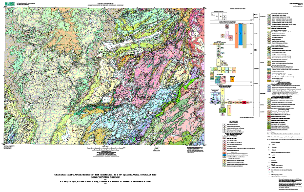
The Roseburg 30' x 60' Quadrangle covers the southeastern margin of the Oregon Coast Range and its tectonic boundary with Mesozoic terranes of the Klamath Mountains (see figures 1 and 2 in pamphlet, also shown on map sheet). The geologic framework of the Roseburg area was established by the pioneering work of Diller (1898), Wells and Peck, (1961) and Ewart Baldwin (1974) and his students (see figure 3 in pamphlet, also shown on map sheet). Baldwin and his students focussed on the history of the Eocene Tyee basin, where the sediments lap across the tectonic boundary with the Mesozoic terranes and record the accretion of the Coast Range basement to the continent. Others have examined the sedimentary fill of the Tyee basin in detail, recognizing the deep marine turbidite facies of the Tyee Formation (Snavely and others, 1964) and proposing several models for the Eocene evolution of the forearc basin (Heller and Ryberg, 1983; Chan and Dott, 1983; Heller and Dickinson, 1985; Molenaar, 1985; see Ryu and others, 1992 for a comprehensive summary). Along the eastern margin of the quadrangle, both the Tyee basin and the Klamath terranes are overlain by Eocene volcanic rocks of the Western Cascade arc (Walker and MacLeod, 1991).
The thick Eocene sedimentary sequence of the Tyee basin has significant oil and gas potential (Armentrout and Suek, 1985; Gautier and others, 1993; Ryu and others, 1996). Although 13 deep test wells have been drilled in the Roseburg quadrangle (see figure 2 and table 1 in pamphlet, also shown on map sheet), exploration to date has been hampered by an incomplete understanding of the basin�s tectonic setting and evolution. In response, the Oregon Department of Geology and Mineral Industries (DOGAMI) initiated a five year assessment of the oil and gas potential of the Tyee basin.
This map is a product of a cooperative effort by the U. S. Geological Survey, Oregon State University, and DOGAMI to systematically map the sedimentary facies and structure of the Tyee basin. New geologic mapping of twenty-eight 7.5' quadrangles is summarized on the map (see figure 3, also shown on map sheet), and the digital database contains geologic information suitable for both 1:100K and 1:24K scale analysis. DOGAMI has published a compilation and synthesis of previous mapping (Niem and Niem, 1990), a basin-wide sequence stratigraphic model and correlations (Ryu and others, 1992), and a report on the oil and gas potential (Ryu and others, 1996). Readers interested in the oil and gas potential of the Roseburg quadrangle should use the map in combination with Ryu and others (1996) to address specific stratigraphic units and structural plays.
Stratigraphic terminology for the Tyee basin adopts the type sections, formation names, and framework of Ryu and others (1992, 1996), which were developed concurrently with the mapping and are recognized throughout the basin. For detailed discussion of nomenclature, type sections, lithology, thickness and distribution, age, contact relationships, and depositional environment of stratigraphic units, the reader is referred to Ryu and others (1992). In this report we focus on the spatial, temporal, and structural relationships between units revealed by geologic mapping. Map unit ages (see figure 4 in pamphlet, also shown on map sheeet) are adjusted slightly from Ryu and others (1992, 1996) to fit new coccolith age determinations (D. Bukry, cited in pamphlet), paleomagnetic polarity data (Simpson, 1977 and new data cited in pamphlet), and the time scale of Berggren and others (1995).

