Skip Links

USGS - science for a changing world

Open-File Report 00-403

Preliminary Report on Geophysics of the Verde River headwaters region, Arizona

By V.E. Langenheim, J.S. Duval, Laurie Wirt, and Ed Dewitt

Thumbnail of and link to report PDF (16 MB)Abstract

This report summarizes the acquisition, data processing, and preliminary interpretation of a high-resolution aeromagnetic and radiometric survey near the confluence of the Big and Little Chino basins in the headwaters of the Verde River, Arizona. The goal of the aeromagnetic study is to improve understanding of the geologic framework as it affects groundwater flow, particularly in relation to the occurrence of springs in the upper Verde River headwaters region. Radiometric data were also collected to map surficial rocks and soils, thus aiding geologic mapping of the basin fill. Additional gravity data were collected to enhance existing coverage.

Both aeromagnetic and gravity data indicate a large gradient along the Big Chino fault, a fault with Quaternary movement. Filtered aeromagnetic data show other possible faults within the basin fill and areas where volcanic rocks are shallowly buried. Gravity lows associated with Big Chino and Williamson Valleys indicate potentially significant accumulations of low-density basin fill. The absence of a gravity low associated with Little Chino Valley indicates that high-density rocks are shallow.

The radiometric maps show higher radioactivity associated with the Tertiary latites and with the sediments derived from them. The surficial materials on the eastern side of the Big Chino Valley are significantly lower in radioactivity and reflect the materials derived from the limestone and basalt east of the valley. The dividing line between the low radioactivity materials to the east and the higher radioactiviy materials to the west coincides approximately with the major drainage system of the valley, locally known as Big Chino Wash. This feature is remarkably straight and is approximately parallel to the Big Chino Fault. The uranium map shows large areas with concentrations greater than 5 ppm eU, and we expect that these areas will have a significantly higher risk potential for indoor radon.

First posted November 29, 2000

  • Report PDF (128 kB)
    Intended  for viewing onscreen only,
    this version consists of the text with links to the figures. The links are designed to work whether you download the of00-403n.pdf to your desktop or whehter you view it in your browser.

For more information about gravity and magnetic data and methods, check out the Geophysical Unit of Menlo Park website

For additional information, contact:
Geology, Minerals, Energy, and Geophysics Science Center
U.S. Geological Survey
345 Middlefield Road, MS 901
Menlo Park, CA 94025-3591
http://geomaps.wr.usgs.gov/gmeg/

Part or all of this report is presented in Portable Document Format (PDF). For best results viewing and printing PDF documents, it is recommended that you download the documents to your computer and open them with Adobe Reader. PDF documents opened from your browser may not display or print as intended. Download the latest version of Adobe Reader, free of charge.


Suggested citation:

Langenheim, V.E., Duval, J.S., Wirt, Laurie, and Dewitt, Ed, 2000, Preliminary Report on Geophysics of the Verde River headwaters region, Arizona: U.S. Geological Survey Open-File Report 00-403, 29 pp., https://pubs.usgs.gov/of/2000/0403/.
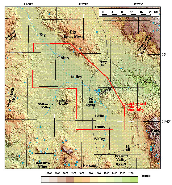


Contents

Introduction

Geologic Setting

Aeromagnetic Data, Maps, and Derivative Products

Radiometric Data and Maps

Gravity Data and Map

Conclusions and Recommendations

Acknowledgments

References

15 Figures

Accessibility FOIA Privacy Policies and Notices

Take Pride in America logo USA.gov logo U.S. Department of the Interior | U.S. Geological Survey
URL: http://pubsdata.usgs.gov/pubs/of/2000/0403/index.html
Page Contact Information: GS Pubs Web Contact
Page Last Modified: Wednesday, 07-Dec-2016 18:16:01 EST