
 Gulf of Mexico GLORIA sidescan sonar geologic interpretation
Metadata:
-
Identification_Information:
-
Citation:
-
Citation_Information:
-
Originator: Valerie Paskevich(comp.)
-
Publication_Date: 19981007
-
Title: Gulf of Mexico GLORIA sidescn sonar geologic interpretation
-
Other_Citation_Details:
-
The geologic interpretation of the Gulf of Mexico GLORIA data was taken
from an image, Gulf_mex.rmp, available on the U.S. Geological Survey Digital
Data Series DDS-15 CD-ROM. The image was created from the geologic interpretations
of the GLORIA images that may be found in the paper atlases that were 500,000
and are referenced as U.S. Geological Survey Miscellaneous Investigations
Series I-1864-A,B (1987).
-
Larger_Work_Citation:
-
Citation_Information:
-
Originator: U.S. Geological Survey, Office of Marine Geology
-
Publication_Date: Unknown
-
Publication_Time: Unknown
-
Title: Exclusive Economic Zone boundary
-
Geospatial_Data_Presentation_Form: map
-
Description:
-
Abstract:
-
This GIS overlay is a component of the U. S Geological Survey, Woods Hole
Field Center's, Gulf of Mexico ArcView GIS database. The Gulf of Mexico
GIS database is intended to organize and display USGS held data and provide
on-line (WWW) access to the data and/or metadata.
-
Purpose:
-
This ArcView GIS layer is the geologic interpretation of the Gulf of Mexico
GLORIA data.
-
Time_Period_of_Content:
-
Time_Period_Information:
-
Single_Date/Time:
-
Calendar_Date: 19871123
-
Currentness_Reference: Publication Date
-
Status:
-
Progress: Complete
-
Maintenance_and_Update_Frequency: None planned
-
Spatial_Domain:
-
Bounding_Coordinates:
-
West_Bounding_Coordinate: -95.7992
-
East_Bounding_Coordinate: -82.0419
-
North_Bounding_Coordinate: 29.2106
-
South_Bounding_Coordinate: 23.7409
-
Keywords:
-
Theme:
-
Theme_Keyword_Thesaurus: General
-
Theme_Keyword: U.S. Geological Survey
-
Theme_Keyword: Woods Hole Field Center
-
Theme_Keyword: Gulf of Mexico database
-
Theme_Keyword: polyline
-
Theme_Keyword: vectors
-
Theme_Keyword: ArcView
-
Theme_Keyword: shapefile
-
Theme_Keyword: Exclusive Economic Zone
-
Theme_Keyword: EEZ
-
Theme_Keyword: geology
-
Theme_Keyword: geologic interpretation
-
Theme_Keyword: GLORIA
-
Place:
-
Place_Keyword_Thesaurus: General
-
Place_Keyword: Gulf of Mexico
-
Access_Constraints: None
-
Use_Constraints:
-
Although this derived data set and it's lineage dataset have been used
by the USGS, no warranty, expressed or implied, is made by the USGS as
to the accuracy of the data and/or related materials. The act of distribution
shall not constitute any such warranty, and no responsibility is assumed
by the USGS in the use of these data or related materials. The U.S. Geological
Survey must be referenced as the originator of the dataset in any future
products or research derived from these data.
-
Point_of_Contact:
-
Contact_Information:
-
Contact_Organization_Primary:
-
Contact_Organization: U. S. Geological Survey
-
Contact_Person: Valerie Paskevich
-
Contact_Position: Computer Specialist
-
Contact_Address:
-
Address_Type: mailing and physical address
-
Address: 384 Woods Hole Road
-
City: Woods Hole
-
State_or_Province: MA
-
Postal_Code: 02543-1598
-
Country: USA
-
Contact_Voice_Telephone: (508) 548-8700 x2281
-
Contact_Facsimile_Telephone: (508) 457-2310
-
Contact_Electronic_Mail_Address: vpaskevich@usgs.gov
-
Hours_of_Service: M-Thu 6:30am-3:30pm; Fri 6:30am-10:30am
-
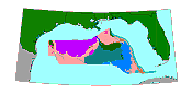
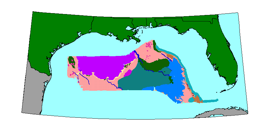
Browse_Graphic:
-
Browse_Graphic_File_Name: geology
-
Browse_Graphic_File_Description: GIF
-
Browse_Graphic_File_Type:
-
Geologic interpretation of the GLORIA sidescan sonar mosaic for the Gulf
of Mexico
-
Native_Data_Set_Environment: ESRI Shapefile format
-
Data_Quality_Information:
-
Logical_Consistency_Report: .
-
Completeness_Report: .
-
Lineage:
-
Source_Information:
-
Source_Citation:
-
Citation_Information:
-
Originator: various(comp.)
-
Publication_Date: Unknown
-
Publication_Time: Unknown
-
Title:
-
CD-ROM Atlas of the Deepwater Parts of the U.S. Exclusive Economic Zone
in the Atlantic Ocean, the Gulf of Mexico, and the Eastern Caribbean Sea
-
Edition: D.C. Twichell and C.F. Polloni
-
Geospatial_Data_Presentation_Form: map
-
Series_Information:
-
Series_Name: U.S. Geological Survey Digital Data Series
-
Issue_Identification: DDS-15
-
Publication_Information:
-
Publication_Place: U.S. Geological Survey, Reston, VA
-
Publisher: USGS, Office of Marine Geology
-
Larger_Work_Citation:
-
Citation_Information:
-
Originator: various(comp.)
-
Publication_Date: Unknown
-
Publication_Time: Unknown
-
Title:
-
U. S. Exclusive Economic Zone, Gulf of Mexico and eastern Caribbean areas
-
Geospatial_Data_Presentation_Form: atlas
-
Series_Information:
-
Series_Name: U.S. Geological Survey Miscellaneous Investigations
-
Issue_Identification: I-1864-A
-
Publication_Information:
-
Publication_Place: U.S. Geological Survey, Reston, VA
-
Publisher: U.S. Geological Survey, Office of Marine Geology
-
Other_Citation_Details:
-
The geologic interpretation of the GLORIA images found in the atlas, I-1864-A,B,
weredigitized and ARC/INFO coverages created. Those coverages were combined
to create a single, psuedo-color coded interpretive map/image for DDS-15.
Unfortunately, the coverages were subsequently lost. Rather than re-digitize
the mosaics, the decision was made to re-create the coverages based on
the image from DDS-15.
-
Source_Scale_Denominator: 5000000
-
Type_of_Source_Media: CD-ROM
-
Source_Time_Period_of_Content:
-
Time_Period_Information:
-
Single_Date/Time:
-
Calendar_Date: 19930603
-
Source_Currentness_Reference: Publication Date
-
Source_Citation_Abbreviation: DDS-15
-
Source_Contribution:
-
The geologic interpretation image, Gulf_mex.rmp, was taken from DDS-15
and used to create vector coverages for ARC/INFO and ArcView.
-
Source_Information:
-
Source_Citation:
-
Citation_Information:
-
Originator: various(comp.)
-
Publication_Date: Unknown
-
Publication_Time: Unknown
-
Title:
-
Atlas of the U.S. Exclusive Economic Zone, Gulf of Mexico and eastern Caribbean
areas
-
Geospatial_Data_Presentation_Form: atlas
-
Series_Information:
-
Series_Name: U.S. Geological Survey Miscellaneous Investigations
-
Issue_Identification: I-1864-A,B
-
Publication_Information:
-
Publication_Place: U.S. Geological Survey, Reston, VA
-
Publisher: U.S. Geological Survey, Office of Marine Geology
-
Source_Scale_Denominator: 500000
-
Type_of_Source_Media: paper
-
Source_Time_Period_of_Content:
-
Time_Period_Information:
-
Single_Date/Time:
-
Calendar_Date: 19851005
-
Source_Currentness_Reference: Publication Date
-
Source_Citation_Abbreviation: I-1864-A,B
-
Source_Contribution:
-
The image showing the geologic interpretation of the Gulf of Mexico GLORIA
data was created by digitizing the expanded interpretations from I-1864-A,B.
The coverages were combined to create a single psuedo-color coded interpretive
map/image for DDS-15. Unfortunately, the ARC coverages were lost. Rather
than re-digitize the interpretations, the decision was made to re-create
the coverages based on the DDS-15 image.
-
Process_Step:
-
Process_Description:
-
The geologic interpretation image was taken from the CD-ROM DDS-15 and
registered to a 250 meter, georeferenced GLORIA image for the entire Gulf
of Mexico. When the geologic interpretation image was registered, the image
was then rasterized to create vector outlines.
-
Source_Used_Citation_Abbreviation: DDS-15
-
Process_Date: 19981019
-
Source_Produced_Citation_Abbreviation: vecsegs1
-
Process_Contact:
-
Contact_Information:
-
Contact_Organization_Primary:
-
Contact_Organization: U. S. Geological Survey
-
Contact_Person: Valerie Paskevich
-
Contact_Position: Computer Specialist
-
Contact_Address:
-
Address_Type: mailing and physical address
-
Address: 384 Woods Hole Road
-
City: Woods Hole
-
State_or_Province: MA
-
Postal_Code: 02543-1598
-
Country: USA
-
Contact_Voice_Telephone: (508) 548-8700 x2281
-
Contact_Facsimile_Telephone: (508) 457-2310
-
Contact_Electronic_Mail_Address: vpaskevich@usgs.gov
-
Process_Step:
-
Process_Description:
-
Due to the stepping in the image found at the geologic boundaries, the
resulting vectors showed the same stepping. The vector information was
editted to smooth the lines. The editted and smoothed vector segments were
exported in ARC/INFO export format.
-
Source_Used_Citation_Abbreviation: vecsegs1
-
Process_Date: 19981110
-
Source_Produced_Citation_Abbreviation: geology.e00
-
Process_Contact:
-
Contact_Information:
-
Contact_Organization_Primary:
-
Contact_Organization: U. S. Geological Survey
-
Contact_Person: Valerie Paskevich
-
Contact_Position: Computer Specialist
-
Contact_Address:
-
Address_Type: mailing and physical address
-
Address: 384 Woods Hole Road
-
City: Woods Hole
-
State_or_Province: MA
-
Postal_Code: 02543-1598
-
Country: USA
-
Contact_Voice_Telephone: (508) 548-8700 x2281
-
Contact_Facsimile_Telephone: (508) 457-2310
-
Contact_Electronic_Mail_Address: vpaskevich@usgs.gov
-
Process_Step:
-
Process_Description:
-
The ARC export file, geology.e00, was imported to ARC as coverage geology
and the polygon coverage was built.
-
Source_Used_Citation_Abbreviation: geology.e00
-
Process_Date: 19981113
-
Source_Produced_Citation_Abbreviation: geology.pat
-
Process_Contact:
-
Contact_Information:
-
Contact_Organization_Primary:
-
Contact_Organization: U. S. Geological Survey
-
Contact_Person: Valerie Paskevich
-
Contact_Position: Computer Specialist
-
Contact_Address:
-
Address_Type: mailing and physical address
-
Address: 384 Woods Hole Road
-
City: Woods Hole
-
State_or_Province: MA
-
Postal_Code: 02543-1598
-
Country: USA
-
Contact_Voice_Telephone: (508) 548-8700 x2281
-
Contact_Facsimile_Telephone: (508) 457-2310
-
Contact_Electronic_Mail_Address: vpaskevich@usgs.gov
-
Process_Step:
-
Process_Description:
-
The ARC polygon coverage, geology.pat, was exported as an ArcView shapefile,
geology.
-
Source_Used_Citation_Abbreviation: geology.pat
-
Process_Date: 19981113
-
Source_Produced_Citation_Abbreviation: geology.shp
-
Source_Produced_Citation_Abbreviation: geology.dbf
-
Source_Produced_Citation_Abbreviation: geology.shx
-
Process_Contact:
-
Contact_Information:
-
Contact_Organization_Primary:
-
Contact_Organization: U. S. Geological Survey
-
Contact_Person: Valerie Paskevich
-
Contact_Position: Computer Specialist
-
Contact_Address:
-
Address_Type: mailing and physical address
-
Address: 384 Woods Hole Road
-
City: Woods Hole
-
State_or_Province: MA
-
Postal_Code: 02543
-
Country: USA
-
Contact_Voice_Telephone: (508) 548-8700 x2281
-
Contact_Facsimile_Telephone: (508) 457-2310
-
Contact_Electronic_Mail_Address: vpaskevich@usgs.gov
-
Process_Step:
-
Process_Description:
-
The ArcView shapefile, geology, was brought into ArcView for final viewing
and verification. No further editting or changes were needed to the shape
file. However, the geology.dbf file was modified to add the fields Geocode,
Description and GeoAbrv.
-
Source_Used_Citation_Abbreviation: geology.shp
-
Source_Used_Citation_Abbreviation: geology.dbf
-
Source_Used_Citation_Abbreviation: geology.shx
-
Process_Date: 19981116
-
Source_Produced_Citation_Abbreviation: geology.shp
-
Source_Produced_Citation_Abbreviation: geology.dbf
-
Source_Produced_Citation_Abbreviation: geology.shx
-
Process_Contact:
-
Contact_Information:
-
Contact_Organization_Primary:
-
Contact_Organization: U. S. Geological Survey
-
Contact_Person: Valerie Paskevich
-
Contact_Position: Computer Specialist
-
Contact_Address:
-
Address_Type: mailing and physical address
-
Address: 384 Woods Hole Road
-
City: Woods Hole
-
State_or_Province: MA
-
Postal_Code: 02543-1598
-
Country: USA
-
Contact_Voice_Telephone: (508) 548-8700 x2281
-
Contact_Facsimile_Telephone: (508) 457-2310
-
Contact_Electronic_Mail_Address: vpaskevich@usgs.gov
-
Spatial_Data_Organization_Information:
-
Direct_Spatial_Reference_Method: Vector
-
Point_and_Vector_Object_Information:
-
SDTS_Terms_Description:
-
SDTS_Point_and_Vector_Object_Type: GT-polygon composed of chains
-
Point_and_Vector_Object_Count: 192
-
Spatial_Reference_Information:
-
Horizontal_Coordinate_System_Definition:
-
Geographic:
-
Latitude_Resolution: .005
-
Longitude_Resolution: .005
-
Geographic_Coordinate_Units: Decimal degrees
-
Geodetic_Model:
-
Horizontal_Datum_Name: North American Datum of 1927
-
Ellipsoid_Name: Clarke 1866
-
Semi-major_Axis: 6378206.4
-
Denominator_of_Flattening_Ratio: 294.98
-
Entity_and_Attribute_Information:
-
Detailed_Description:
-
Entity_Type:
-
Entity_Type_Label: geology.dbf
-
Entity_Type_Definition: Shapefile Attribute Table
-
Entity_Type_Definition_Source: None
-
Attribute:
-
Attribute_Label: Area
-
Attribute_Definition:
-
Area of polygon. The Area is carried over from the AREA attribute in ArcInfo.
AREA is an ArcInfo internal control parameter and has no relevance to the
use of the data.
-
Attribute_Definition_Source: Software computed
-
Attribute_Domain_Values:
-
Range_Domain:
-
Range_Domain_Minimum: 0
-
Range_Domain_Maximum: 7.884
-
Attribute:
-
Attribute_Label: Perimeter
-
Attribute_Definition:
-
Perimeter of polygon. The Perimeter is carried over from the PERIMETER
attribute in ArcInfo. PERIMTER is an ArcInfo internal control parameter
and has no applicable relevance to the use of the data.
-
Attribute_Definition_Source: Software computed
-
Attribute_Domain_Values:
-
Range_Domain:
-
Range_Domain_Minimum: 0.023
-
Range_Domain_Maximum: 30.144
-
Attribute:
-
Attribute_Label: Geology_
-
Attribute_Definition:
-
Carried over from the ArcInfo attribute GEOLOGY# GEOLOGY# is an ArcInfo
internal control parameter and has no applicable relevance to the use of
the data.
-
Attribute_Definition_Source: Software computed
-
Attribute_Domain_Values:
-
Range_Domain:
-
Range_Domain_Minimum: 2
-
Range_Domain_Maximum: 193
-
Attribute:
-
Attribute_Label: Geology_id
-
Attribute_Definition:
-
Carried over from the ArcInfo attribute GEOLOGY-ID. GEOLOGY-ID is an ArcInfo
internal control parameter and has no applicable relevance to the use of
the data.
-
Attribute_Definition_Source: Software computed
-
Attribute_Domain_Values:
-
Range_Domain:
-
Range_Domain_Minimum: 1
-
Range_Domain_Maximum: 192
-
Attribute:
-
Attribute_Label: Geocode
-
Attribute_Definition:
-
assigned value from original geologic interpretation image ued for color
coding
-
Attribute_Definition_Source: User Defined
-
Attribute_Domain_Values:
-
Range_Domain:
-
Range_Domain_Minimum: 4
-
Range_Domain_Maximum: 41
-
Attribute:
-
Attribute_Label: Description
-
Attribute_Definition:
-
text description assigned to the polygon feature of the geologic interpretation
Abyssal Plain - Hemipelagic Drape
canyon & channel
Fan; Depositional Lobe Facies
Fan; Linear Stripe Facies
Mass Wasting; Carbonate debris flow deposits
Mass Wasting; Terrigenous debris flow deposits
Mass Wasting; Mesozoic/Cenozoic carbonate outcrop
Pleisocene carbonate mud
Salt Deformation Province
Salt Diapir Seamount
Sediment Waves
Sigsbee Escarpment
No Data
Attribute_Definition_Source: User Defined
Attribute_Domain_Values:
-
Unrepresentable_Domain: Character field
Attribute:
-
Attribute_Label: GeoAbrv
-
Attribute_Definition:
-
Abbreviation/legend code for geologic interpretation.
Ah - Abyssal Plain - Hemipelagic Drape
Bs - Seamount
Cc - canyon & channel
Csw - Sediment Waves
Fdl - Fan; Depositional Lobe Facies
Fls - Fan; Linear Stripe Facies
Lmc - Mesozoic/Cenozoic carbonate outcrop
Lp - Pleisocene carbonate mud
MWdfc - Mass Wasting; Carbonate debris flow deposits
MWdft - Mass Wasting; Terrigenous debris flow deposits
MWtc - Mass Wasting; Carbonate talus deposits
Sd - Salt Diapir
Sdp - Salt Deformation Province
Se - Sigsbee Escarpment
No Data
Attribute_Definition_Source: User Defined
Attribute_Domain_Values:
-
Unrepresentable_Domain: Character field
-
Distribution_Information:
-
Distributor:
-
Contact_Information:
-
Contact_Organization_Primary:
-
Contact_Organization: U. S. Geological Survey
-
Contact_Person: Valerie Paskevich
-
Contact_Position: Computer Specialist
-
Contact_Address:
-
Address_Type: mailing and physical address
-
Address: 384 Woods Hole Road
-
City: Woods Hole
-
State_or_Province: MA
-
Postal_Code: 02543-1598
-
Country: USA
-
Contact_Voice_Telephone: (508) 548-8700 x2281
-
Contact_Facsimile_Telephone: (508) 457-2310
-
Contact_Electronic_Mail_Address: vpaskevich@usgs.gov
-
Resource_Description: Gulf of Mexico GIS database: geology.shp
-
Distribution_Liability:
-
Although this derived data set and it's lineage dataset have been used
by the USGS, no warranty, expressed or implied, is made by the USGS as
to the accuracy of the data and/or related materials. The act of distribution
shall not constitute any such warranty, and no responsibility is assumed
by the USGS in the use of these data or related materials.
-
Standard_Order_Process:
-
Digital_Form:
-
Digital_Transfer_Information:
-
Format_Name: ARCE
-
Format_Information_Content:
-
geology.shp
-
geology.dbf
-
geology.shx
-
File_Decompression_Technique: No compression applied
-
Transfer_Size: 659Kb
-
Digital_Transfer_Option:
-
Offline_Option:
-
Offline_Media: CD-ROM
-
Recording_Capacity:
-
Recording_Density: 650
-
Recording_Density_Units: Mbytes
-
Recording_Format: ISO 9600
-
Compatibility_Information:
-
The user must have a system with a CD-ROM capable of reading an ISO-9660
standard CD-ROM disk. To browse the information contained on this disk,
the user must also have a current version of WWW browser available.
-
Digital_Form:
-
Digital_Transfer_Information:
-
Format_Name: ARCE
-
Format_Information_Content:
-
The three ArcView shapefiles (geology.dbf, geology.shp, geology.shx) comprising
the GLORIA geologic interpretation (geology) coverage.
-
File_Decompression_Technique: zip
-
Transfer_Size: 243Kb
-
Digital_Transfer_Option:
-
Offline_Option:
-
Offline_Media: CD-ROM
-
Recording_Capacity:
-
Recording_Density: 650
-
Recording_Density_Units: Mbytes
-
Recording_Format: ISO 9600
-
Compatibility_Information:
-
The user must have a system with a CD-ROM capable of reading an ISO-9660
standard CD-ROM disk. To browse the information contained on this disk,
the user must also have a current version of WWW browser available.
-
Fees: none
-
Technical_Prerequisites:
-
Access to the data and information contained on this CD-ROM was developed
using the HyperText Markup Language (HTML) utilized by the World Wide Web
(WWW) project. Development of the CD-ROM ocumentation and user interface
in HTML allows a user to access the information by using a variety of WWW
information browsers (i.e. NCSA Mosaic, Netscape, Microsoft Explorer) to
facilitate browsing and locating information and data. To access the information
contained on this disk with a WWW client browser, open the file 'intro.htm'
at the top level directory of this CD-ROM with your selected browser.
-
This CD-ROM should be readable by a variety of operating systems including
Windows 95/98/NT, Macintosh and UNIX.
-
The Gulf of Mexico GLORIA geologic interpretation is available in ArcView
shapefile format. The use must have ArcView to read and process the data
file or another GIS application package capable of importing the data.
-
Metadata_Reference_Information:
-
Metadata_Date: 19990819
-
Metadata_Contact:
-
Contact_Information:
-
Contact_Organization_Primary:
-
Contact_Organization: U. S. Geological Survey
-
Contact_Person: Valerie Paskevich
-
Contact_Position: Computer Specialist
-
Contact_Address:
-
Address_Type: mailing and physical address
-
Address: 384 Woods Hole Rd.
-
City: Woods Hole
-
State_or_Province: MA
-
Postal_Code: 02543-1598
-
Country: USA
-
Contact_Voice_Telephone: (508) 548-8700 x2281
-
Contact_Facsimile_Telephone: (508) 457-2310
-
Contact_Electronic_Mail_Address: vpaskevich@usgs.gov
-
Metadata_Standard_Name: FGDC Content Standards for Digital Geospatial
Metadata
-
Metadata_Standard_Version: CSDGM version 2
-
Metadata_Time_Convention: Local time
-
Metadata_Access_Constraints: None
-
Metadata_Use_Constraints: None
Generated by mp
on Thu Aug 19 11:31:13 1999
 Gulf of Mexico GLORIA sidescan sonar geologic interpretation