
|
||||||||||||||||||||||||||||
|
derived from Schwab, W.C., Thieler, E.R., Denny, J.F., Danforth, W.W. 2000. Seafloor Sediment Distribution Off Southern Long Island, New York: U.S. Geological Survey Open-File Report 00-243
|
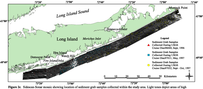
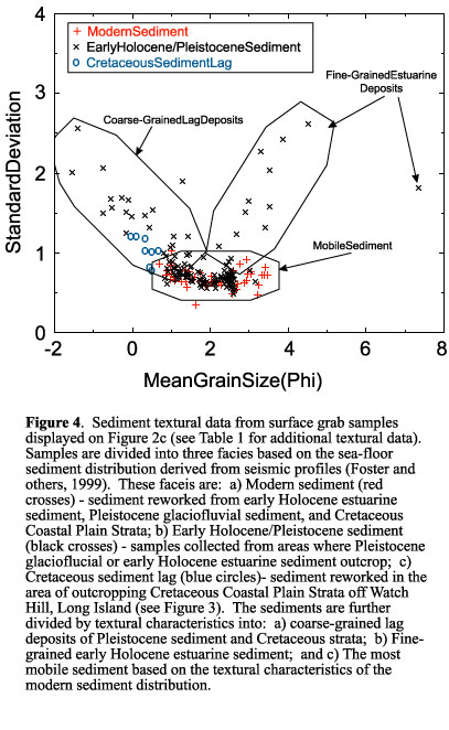
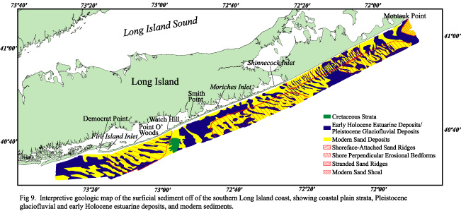
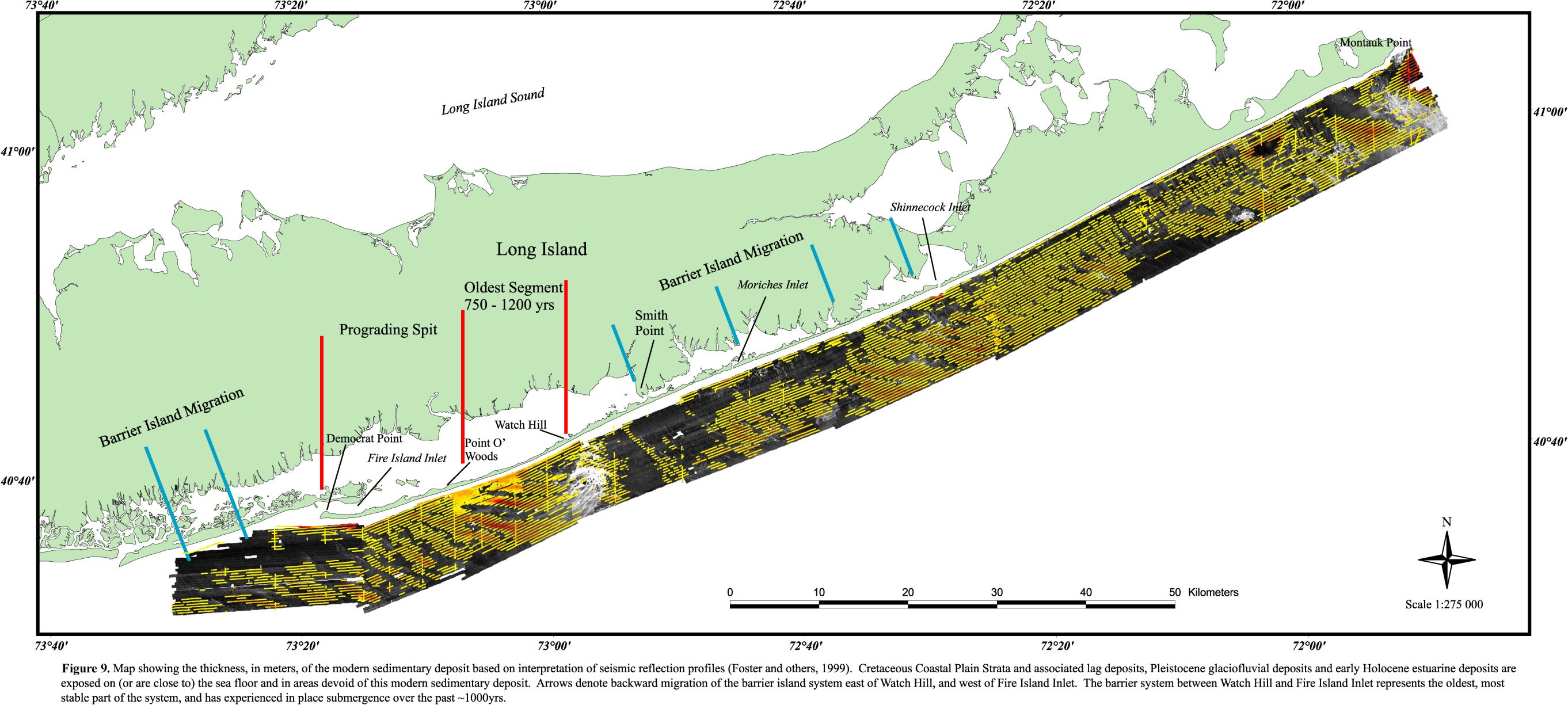
Coastal Erosion along the south shore of Long Island, New York, between Fire Island Inlet and Montauk Point (Fig. 1), has received much engineering, scientific, and political attention during the past 40 years (e.g., Leatherman and Allen, 1985; U.S. Army Corps of Engineers, 1993). The interest is due to significant tourism to the area's parks and beaches, the presence of numerous coastal communities, a densely populated mainland, and an active local fishing industry; all of which are negatively impacted by coastal erosion. Coastlines with limited sand supplies, such as much of the Atlantic margin of the United States, are significantly influenced by the geologic framework beneath and seaward of the littoral zone (Davis and Kuhn, 1985; Evans and others, 1985; Riggs and others, 1995; Thieler and others, 1995; Schwab and others, 1999, 2000). This antecedent geology can determine the morphology of the shoreface and inner-continental shelf and strongly influence modern beach behavior. A better understanding of sediment dynamics in coastal areas can be attained by mapping the surface sediment distribution and subsurface stratigraphy of the lower shoreface and inner-continental shelf. In 1996, the U.S. Geological Survey, in cooperation with the U.S. Army Corps of Engineers, began a program to produce geologic maps of the sea floor along the south shore of Long Island using high-resolution sidescan-sonar, subbottom profiling, and sediment sampling techniques. The study area extends from the 8-m isobath to about 10 km offshore. The goals of the investigation are to determine regional-scale sand-resource availability for planned beach-nourishment programs and to investigate the role that inner-shelf morphology and geologic framework play in the evolution of this coastal region. Regional interpretation of these mapping products are reported in Schwab and others (1999, 2000). Maps showing the Quaternary stratigraphy of the study area were presented by Foster and others (1999). In this report, we present the sidescan-sonar imagery and interpretation based on the stratigraphic framework presented in Foster and others (1999) and on the textural analysis of bottom sediment samples (Table 1). Back to the top of the page The study area was surveyed using high-resolution sidescan-sonar, seismic-reflection, bathymetric, and sediment sampling techniques in May 1996 aboard the research vessel SEAWARD EXPLORER (USGS Cruise SEAX96004) and in September-October 1996, May 1997, and September-October 1997 aboard the research vessel DIANE G (USGS Cruises Dian96040, Dian97011, and Dian97032, respectively). Selected areas within the study area were surveyed using a multibeam echosounder in November 1998 using the Canadian Hydrographic Survey research Vessel FREDERICK G. CREED (USGS Cruise CRED98015) in order to acquire high-resolution bathymetric data coincident with sidescan-sonar backscatter data. Geophysical data were acquired using a 100-105 kHz swept-frequency sidescan-sonar system, a 2-7 kHz swept FM (CHIRP) subbottom profiler, a 300-3000 Hz Geopulse boomer subbottom profiler, a 100-3000 Hz sparker system, a 200 kHz fathometer, and a Simrad EM1000 multibeam echosounder. Ship tracklines were selected to provide continuous sidescan-sonar coverage of the sea floor, average line spacing was 300 m. A full description of data acquisition and processing routines applied to the subbottom data is presented in Foster and others (1999). Sediment samples were collected using a Van Veen grab sampler. The sidescan-sonar data were logged digitally at a sample rate yielding a 0.18-m pixel resolution in the across-track direction and approximately 0.14-m pixel resolution in the along-track direction, following the methodology outlined in Danforth and others (1991). A median filter routine (Danforth 1997) was applied to the sidescan-sonar data to remove speckle noise, resulting in a 0.73-m pixel size. The data were further processed and mosaicked using procedures described in Paskevich (1992) and Danforth (1997), resulting in an enhanced, geographically correct, sidescan-sonar mosaic with a 4-m/pixel resolution. Fathometer data were collected digitally and processed to remove water-depth variations due to vessel heave, transducer draft, and tidal fluctuations. The vertical resolution of the bathymetric data is about 1 m. The data were gridded and contoured with a 300-m grid using the EarthVision software package (Dynamic Graphics, Inc.). The multibeam data were acquired with a Simrad EM 1000 Multibeam Echosounder. This system utilizes 60 electronically aimed beams spaced at intervals of 2.5� that can ensonify a swath of sea floor up to 7.5 times the water depth. Horizontal resolution, or the footprint of an individual beam on the sea floor, is approximately 10 percent of the water depth. Vertical resolution is approximately 1 percent of the water depth or better. Thus for the range of water depths within the survey area, 20 � 50 m, the horizontal resolution is 1.3-5.0 m and the vertical resolution is 0.2 - 0.5 m. The multibeam data were acquired digitally and processed using software developed by the Ocean Mapping Group, University of New Brunswick (see World Wide Web URL http//www.omg.unb.ca/~jhc/SwathEd.html). Tidal elevations measured at the NOAA Sandy Hook station were used to adjust the data for the tidal fluctuations and reference the data to mean lower low water. Grain-size analyses of the sediment samples were conducted using a combination of sieving and Coulter Counter techniques following the methodology of Poppe and others (1985). Ship position for all cruises was determined from a Differential Global Positional System (DGPS). The sidescan-sonar towfish was navigated relative to the ship using an acoustic-ranging system. The position of the towfish was calculated assuming the towfish was directly behind the research vessel; i.e., towfish followed the ship trackline. This assumption is relatively accurate when the research vessel is running in a straight line, with a small amount of tow cable deployed. However, because the towfish position error increases in turns by 10's of meters, data collected during turns were discarded. In using the navigation data, we conclude that the position of the bathymetric data, sample locations, and the sidescan-sonar imagery are accurate to within 5 m. Back to the top of the page Long Island marks the southern boundary of the late Pleistocene glacial advance in the eastern part of North America (Stone and Borns, 1986). Two end moraines are superimposed along the western part of northern Long Island. The moraines bifurcate in eastern Long Island, where each moraine forms the core of the two peninsulas north and south of Great Peconic Bay (Fig. 1). The topography of Long Island is a reflection of this glacial history and exhibits greater relief on the northern side, where the two moraines are superimposed, and a gentler southward dipping gradient on the outwash plains that make up much of the southern side of the island. The coast from Southampton to Montauk Point is a headland region where the Ronkonkoma moraine and associated outwash sediment are eroded directly by wave action (Williams, 1976). The south shore of Long Island west of Southampton consists of reworked glaciofluvial outwash and includes shallow back-barrier bays, marshes, and low-relief, sandy (fine- to medium-grained sand) barrier islands. Leatherman (1989) identified 26 historical inlet sites along the Fire Island barrier-island system east of Watch Hill (Fig. 1). Inlet breaches account for most of the littoral sand transport into the back-barrier bays, and relict flood-tidal deltas are common throughout Moriches and Shinnecock Bays (Leatherman, 1985). The great number of relict flood-tidal deltas east of Watch Hill and outcrops of tidal-marsh sediments on the upper shoreface provide evidence of landward migration of this portion of the barrier-island system (Leatherman and Allen, 1985). In contrast, most of Fire Island west of Watch Hill has experienced in-place submergence over the past ~1000 yr (Sanders and Kumar, 1975; Leatherman, 1985; Leatherman and Allen, 1985). From the early 1800's until 1931, the Fire Island barrier-island system from Shinnecock Bay west to Fire Island Inlet, formed a single spit. A strong storm in 1931 opened Moriches Inlet and the "great hurricane" of 1938 opened Shinnecock Inlet and 11 other smaller inlets between Shinnecock and Moriches Inlets (Howard, 1939). All of these inlets subsequently closed naturally except Shinnecock and Moriches Inlets, which were stabilized by jetties in 1954. The east side of Fire Island Inlet was stabilized with a jetty in 1940. Back to the top of the page The sidescan-sonar imagery (Figs. 2a, 2b, and 2c) identifies a range of features and sea-floor environments in the study area, and provides insight into the processes controlling the distribution of sediments in the nearshore region (Schwab and others, 1999, 2000). Sedimentary deposits exposed on the inner-continental shelf off southern Long Island include Cretaceous-age coastal plain strata, Pleistocene glaciofluvial deposits, early Holocene estuarine deposits, and modern reworked sand deposits (Foster and others, 1999). Coastal Plain Strata Approximately 6 km offshore of Watch Hill, a large outcrop of Cretaceous strata is visible on both the sidescan-sonar imagery (Fig. 3) and in subbottom profiles (Foster and others, 1999; Schwab and others 1999, 2000). Outcropping Upper Cretaceous to early Tertiary coastal-plain strata and associated lag deposits of gravel have been identified on the continental shelf throughout the New York Bight Apex (Williams and Duane, 1974; Williams, 1976; Williams and Meisburger, 1987). These outcropping strata are poorly lithified, and are displayed as complex areas of high backscatter on sidescan-sonar imagery (Schwab and others, 1997a, 1997b). Planar internal reflectors identify the Cretaceous strata on subbottom profiles and show that these strata dip and thicken to the southeast along the entire length of Long Island (Williams 1976). The outcropping Cretaceous strata offshore of Watch Hill are probably composed of interbedded marine deposits of clay, silt, and sand corresponding to the Monmouth Group (Williams, 1976; Smolensky and others, 1989; Foster and others, 1999; Schwab and others, 1999, 2000). Here, we interpret a series of northeast-trending, high-backscatter lineations on the sidescan-sonar imagery (Fig. 3) to be an expression of differential erosion of bedding planes in the Cretaceous strata that strike northeast and dip to the southeast. A regional unconformity is visible in subbottom profiles throughout the study area, where the upper Cretaceous to early Tertiary strata are buried by a veneer of poorly to moderately sorted coarse sandy Quaternary sediment (Williams, 1976; Schwab and others 1997a, 1997b, 1999, 2000; Foster and others, 1999). Surface sediment samples from the area of the outcrop have mean grain sizes ranging from 0.00-0.70 phi (1.00-0.62 mm) and standard deviation of about 0.9-1.2 (Fig. 4). At the seaward limit of the study area, the outcropping Cretaceous strata (Fig. 3) form a terrace which stands 3 to 4 m above the adjacent sea floor to the east (Fig. 2a). Areas of high-backscatter on the sidescan-sonar imagery along the east flank of this terrace are interpreted to be coarse-grained sand and gravel lag deposits (Fig. 4). The lag formed from erosion of the Cretaceous strata and overlying Pleistocene outwash deposits during the marine transgression and continued reworking by modern oceanographic processes (Schwab and others, 1999; 2000). The relatively flat regional unconformity that defines the upper surface of the Cretaceous strata deepens slightly toward the eastern end of the study area (Foster and others, 1999). Thus, throughout the remainder of the study area, the Cretaceous strata are buried by a blanket of Quaternary sediment which, on average, increases in thickness from about 15 m offshore of Fire Island Inlet to about 34 m offshore of Montauk Point (Foster and others, 1999). Pleistocene and Early Holocene Sediments Williams (1976) indicated that a seismic reflector defines where Upper Cretaceous coastal-plain strata are unconformably overlain by Pleistocene sediments south of Long Island, with no preservation of Tertiary sedimentary units. Using well-log data, this reflector has also been identified as a contact between Upper Cretaceous and Pleistocene sediment under the adjacent areas of Long Island (Suter and others, 1949; Smolensky and others, 1989). Offshore, the upper surface of the Pleistocene sedimentary deposit is cut by numerous paleochannels, which were subsequently filled with a transgressive sequence composed of reworked Pleistocene glaciofluvial gravelly deposits and early Holocene estuarine deposits (U.S. Army Corps of Engineers, unpublished data; Schwab and others, 1999, 2000). Where exposed at the sea floor (Fig. 5), these early Holocene, channel-fill, estuarine sediments have mean grain sizes that are typically finer than 2.0 phi (<0.25 mm) and a standard deviation greater than 1.0 (Fig. 4). Vibracores (U.S. Army Corps of Engineers, unpublished data) and surface grab samples (Fig. 4; Table 1) collected outside these paleochannels suggest that much of the upper few meters of the Pleistocene glaciofluvial deposit is composed of fine-grained sand to gravel; sediments coarser typically than 2 phi. Pleistocene glaciofluvial deposits are exposed on the inner-continental shelf or buried by a veneer (< 1 m) of reworked modern fine sand over much of the study area. Where Pleistocene sediment is being reworked at the sea floor, such as in the troughs between the modern, shoreface-attached sand ridges west of Watch Hill, sidescan-sonar imagery show numerous high-backscatter lineations oriented at approximately 60� oblique to the shoreline (Figs. 6a and 7). Multibeam bathymetry data reveal that these lineations are located in the troughs of long-crested bedforms typically less than 1 m high (Fig. 6b). We suspect that these bedforms are caused by long-term erosion of the inner-continental shelf, where the Pleistocene and early Holocene sediments are being reworked. The relatively low- backscatter, fine- to medium-grained sand component is being transported generally along-shore to the west, leaving behind a medium- to coarse-grained, winnowed lag deposit, which causes the high backscatter lineations on the sidescan-sonar imagery. Sediment grab samples show that these areas of relatively high backscatter correlate to areas of poorly to very poorly sorted medium- to very coarse-grained sand and gravel; mean grain sizes are commonly coarser than 1.0 phi (> 0.50 mm) and standard deviation greater than 1.0 (Fig. 4). In the area between Napeague and Southampton, sidescan-sonar (Fig. 2a) and multibeam data (Fig. 8) collected where Pleistocene sediments are exposed on the sea floor, reveal a different morphology. Here, this exposure of glaciofluvial sediment, proximal to the Ronkonkoma Moraine, has been eroded into a series of shore-perpendicular sand waves with a wavelength of about 700 m and a height of about 1 m. Modern Sediments The Holocene sedimentary deposits contain a relict and modern component. Early Holocene estuarine sediment fills the paleochannels that are cut into the surface of the Pleistocene sedimentary deposits. These sediments represent a relict phase of deposition prior to marine transgression. Modern sediment lies unconformably atop the Pleistocene glaciofluvial and early Holocene estuarine deposits (Foster and others, 1999; Schwab and others, 1999, 2000). This unconformity has been interpreted to be the Holocene ravinement surface (Schwab and others, 1999, 2000). Note that the term "modern sediment" is used in a descriptive sense here, meaning a sedimentary deposit that lies above the time-transgressive Holocene ravinement surface. Where of sufficient thickness, the modern sedimentary deposit is organized into a series of sand ridges and are visible as areas of low backscatter on sidescan-sonar imagery (Fig. 9) and multibeam data (Fig. 6a). West of the Watch Hill area, the modern sand ridges are oriented at angles of 30�-40� to the shoreline, opening to the east (Fig. 9). These sand ridges are attached, or in close proximity to, a well-developed nearshore bar system found off Fire Island in water depths less than 8 m (Allen and Psuty, 1987). The shoreface-attached sand ridges appear as areas of relatively low backscatter on the sidescan-sonar imagery; slightly coarser grained, higher backscatter Pleistocene sediment is exposed on the troughs between the sand ridges (Fig. 6a). This field of sand ridges extends from the shoreward limit of the study area to about 20 km offshore (Duane and others, 1972). The ridges are up to 5 m thick immediately west of the outcropping Cretaceous strata off Watch Hill (Foster and others, 1999). They become progressively thinner farther westward and are less than 1 m thick off Fire Island Inlet. Surface samples (Fig. 4, Table 1) and vibracores (U.S. Army Corps of Engineers, unpublished data) show that these ridges are composed of very well to moderately sorted, medium- to very fine-grained sand. Mean grain sizes range from approximately 1.0-3.5 phi (0.50-0.09 mm); standard deviations range from about 0.34-0.91 (Fig. 4, and Table 1). Two additional sets of modern sand ridges, also oriented at angles of 30�-40� to the shoreline, are located east of Watch Hill (Fig. 9), however these ridges are located seaward of the 18-m isobath and thus are not attached to the shoreface. Both sets, one off Shinnecock Inlet and the other south of Montauk Point, reach a maximum of 3 m and thin to the west. Finally, a modern shoal up to 12 m thick exists southeast of Montauk Point (Fig. 9). Surface samples show that both sets of sand ridges and the shoal are texturally similar to the sand ridges west of Watch Hill; mean grain sizes range from about 0.4-3.0 phi (0.76-0.13 mm) and standard deviation from about 0.5-0.9 (Fig. 4, Table 1). Back to the top of the page In most areas, a practical understanding of sediment transport from just seaward of the surf zone to inner-shelf depths is rudimentary at best (e.g., Nittrouer and Wright, 1994). Although shore-parallel sediment transport in the littoral zone is widely accepted to be a primary factor controlling coastal behavior, the importance of cross-shelf sediment flux is poorly understood. Interpretation of our mapping investigation of the nearshore region offshore of southern Long Island links the evolution of the Fire Island barrier-island system to the geologic framework of the adjacent inner-continental shelf (Schwab and others, 1999, 2000). The physiography of the upper surface of the Cretaceous strata exerts a primary control on the modern sea floor (Foster and others, 1999; Schwab and others, 1999, 2000). Outcropping Cretaceous strata off Watch Hill form the core of a local bathymetric high (Figs. 2a and 3). We conclude that the outcropping Cretaceous strata offshore of Watch Hill and the deposit of Pleistocene sediment shoreward of this outcrop (Foster and others, 1999) were the core of a subaerial headland during the Holocene marine transgression and may continue to influence sediment deposition as a submerged headland. We infer that erosion of this headland during transgression provided the sediment that has since been reworked by oceanographic processes (e.g., Duane and others, 1972; Swift and Field, 1981; Swift and others, 1984; Trowbridge, 1995; Calvette and others, 1999) into a field of sand ridges west of Watch Hill (Schwab and others, 1999, 2000) (Fig. 9). The fact that these ridges thin progressively to the west (farther downdrift from the headland source area) further supports our hypothesis that the inner-continental shelf off Watch Hill was (and is) an eroding headland. The oldest (~750-1300 yr) and most stable part of the barrier-island system is located approximately between Watch Hill and Point 'O Woods (Leatherman and Allen, 1985), shoreward of the outcropping Cretaceous strata and the thickest modern sand ridges (Fig. 9). Although the physical processes controlling cross-shelf sediment flux remain elusive, we conclude that an onshore sediment flux from the sand ridges west of Watch Hill provided, and likely continues to provide, enough sediment to the downdrift beaches west of Watch Hill to maintain island stability. A number of sediment budgets have been developed for the southern shore of Long Island, from Montauk Point to Fire Island Inlet (U.S. Army Corps of Engineers, 1958; Taney, 1961a, 1961b; Panuzio, 1968; RPI, 1985; Kana, 1995; Rosati and others, 1999). Longshore sediment transport to the west along southern Long Island is initiated at Montauk Point. Estimates of longshore transport range from 58,000-76,500 m3yr-1 8 km west of Montauk Point, from 219,000-233,000 m3yr-1 past Shinnecock Inlet, and from 45,000-230,000 m3yr-1 past Moriches Inlet (Taney, 1961a, 1961b; RPI, 1983; Kana, 1995). In comparison, at the downdrift end of the study area at Democrat Point, longshore sediment transport rates have been estimated to average between 306,000-467,000 m3yr-1(Taney, 1961a, 1961b; RPI, 1983; Kana, 1995). In fact, Democrat Point accreted westward approximately 8 km between 1825 and 1940 or about 64 m yr-1 (U.S. Army Corps of Engineers, 1958; Kumar and Sanders, 1974). The estimated sediment budgets suggest a significant volume of sediment must be added to the system between Moriches Inlet and Democrat Point. The nature of this "deficit" in the sediment budget has been a topic of speculation for some time (Saville, 1960; Taney, 1961a, 1961b; Panuzio, 1968; Williams, 1976; Ash, 1979; McCormick and Toscano, 1981; Leatherman, 1985; Williams and Meisburger, 1987; Kana, 1995; Rosati and others, 1999). Most studies suggest that an offshore source of sediment accounts for the additional sediment. Results of our mapping efforts support previous suggestions that the deficit in the sediment budget must be accounted for from offshore sources (Schwab and others, 1999, 2000), in that, our hypothesized onshore sediment flux from the sand ridges west of Watch Hill must introduce sufficient sediment into the littoral system for spit growth. Reworked modern sedimentary deposits are absent or extremely thin on much of the inner shelf landward of the 18-m isobath between Watch Hill and Southampton (Fig. 9). The barrier-island system adjacent to this segment of the inner-continental shelf has been migrating rapidly but intermittently landward due to the creation of inlets and subsequent bayside accretion at 50-75 yr intervals (Leatherman and Allen, 1985). For example, the barrier-island in the vicinity of Moriches Inlet has migrated half of its 300-m width since 1970. In comparison, there have been no inlet breaches west of Watch Hill in historic time; the barrier island has essentially been drowned slowly in place and aggrading vertically (Leatherman and Allen, 1985). We attribute the fact that the barrier-island segment east of Watch Hill is migrating landward at a faster rate than the western segment due to a relatively smaller sediment supply on the inner-continental shelf east of Watch Hill. The hypothesis of onshore sediment transport identifies the modern sedimentary deposits (components reworked from underlying Quaternary and Cretaceous material) as the more mobile sediment in this nearshore environment (Fig. 4). This contrasts with the coarser grained lag deposits derived from erosion of Pleistocene sediments and Cretaceous strata and the cohesive early Holocene estuarine channel-fill deposits. Areas on the inner-continental shelf where these Pleistocene and early Holocene channel-fill deposits (or Cretaceous strata) are exposed (Fig. 5), such as the nearshore segment of the inner shelf between Watch Hill and Montauk Point, were formed as a result of the active formation and modification of a ravinement surface. Some surficial sediment mapped as outcropping Pleistocene or Holocene channel-fill deposits on Figure 9 is texturally similar to the mobile sediment (Fig. 4) and may therefore be incorrectly classified; it is also likely mobile and therefore part of the modern sediment deposit blanketing parts of the inner shelf. This uncertainty in distinguishing a veneer of modern sediment from the exposed Pleistocene fluvioglacial or Holocene channel-fill deposits is due to the resolution limits of the subbottom profiles, which preclude the mapping of modern sediment deposits that are less than 0.5 m thick (Foster and others, 1999). Shore-oblique sand ridges were mapped east of Watch Hill, approximately between Moriches Inlet and Southampton and between Napeague and Montauk Point in water depths greater than about 18 m (Fig. 9). We suspect that these sand ridges, interpreted as modern sedimentary deposits, were initially attached to a shoreface of similar configuration to those present west of Watch Hill. They were subsequently stranded due to late Holocene marine transgression, as indicated in the model of sand-ridge evolution presented by Swift and Field (1981) and Swift and others (1984). This interpretation requires the existence of a paleo-shoreline located at approximately the 18-m isobath (Schwab and others, 1999, 2000). Although the shoreface-connected sand ridges off western Fire Island are thought to have evolved from erosion of an emergent headland off Watch Hill, it is not clear where the sediment that formed the sand ridges off Shinnecock Bay or off Montauk Point originated. There are no indications that a headland existed updrift, as is the case for the sand ridges west of Watch Hill. Mapping results show that sediment presently eroded from the headland area east of Southampton remains in the littoral zone; there is no or little modern sediment on the inner shelf in water depths less than 18 m (Fig.9). Since the rate of eustatic sea-level rise was greater during the early Holocene than the late Holocene (Milliman and Emery 1968; Fairbanks 1989), it is reasonable to speculate that erosion rates of the headland area east of Southampton were higher during the early Holocene, thus introducing more sediment onto the inner-continental shelf which was subsequently reworked into sand ridges that are now detached from the shoreface. Back to the top of the page The late Holocene evolution of the Fire Island barrier-island is linked directly to the geologic framework of the inner-continental shelf. Mapping results show that the modern physiography of the inner-continental shelf off southern Long Island is an expression of antecedent geology and glacial history, as well as oceanographic processes acting on the sea floor during Holocene marine transgression. The upper surface of the Cretaceous strata provided the foundation for deposition of Quaternary sediment and formed the core of a subaerial headland off Watch Hill during times of lower sea level. The modern sediment deposit was formed from erosion of both the headland areas east of Southampton and off Watch Hill and the inner-continental shelf during Holocene marine transgression. A net onshore component of sediment flux of this modern sediment deposit from the inner shelf to the littoral zone appears to have significantly affected the evolution of the Fire Island barrier-island system. There is a larger modern sediment supply on the inner-continental shelf west of Watch Hill. This sediment supply fed the formation of a field of shoreface-attached sand ridges. Onshore sediment flux from the inner-continental shelf increased the sediment volume available to maintain island stability between Watch Hill and Point O' Woods and for spit growth west of Point O'Woods. In contrast, east of Watch Hill, there is no Cretaceous strata or significant modern sedimentary deposit on the inner-continental shelf in depths shallower than about 18 m. Therefore, the only inner-shelf, sandy sediment available to supply the eastern beaches is the relatively coarser grained, less mobile Pleistocene glaciofluvial and Holocene channel-fill material. As a result, the barrier islands east of Watch Hill are transgressive, and have been more susceptible to inlet breaching. Back to the top of the page |
|||||||||||||||||||||||||||


