|
|
|
| Introduction | |
| Methods and Analysis | |
| Results | |
| Discussion | |
| Summary | |
| Acknowledgments | |
| References | |
| Figure Captions | |
| Table Captions | |
| Digital Data and Metadata | |
| Back to Table of Contents | |
|
|
|

Chapter 6
|
|
|
| Introduction | |
| Methods and Analysis | |
| Results | |
| Discussion | |
| Summary | |
| Acknowledgments | |
| References | |
| Figure Captions | |
| Table Captions | |
| Digital Data and Metadata | |
| Back to Table of Contents | |
|
|
|
Knowledge of the magnitude of contaminant concentration in sediments
is important for regulation of contaminant discharges as well as management
of the natural resources throughout the Long Island Sound watershed.
A geochemical study of Long Island Sound was undertaken to understand the
regional concentrations, distribution, and fates of contaminants in sediments
as a component of a larger study by the U.S. Geological Survey. In
this report, we present tables containing the analytical data for each
of the analyses in the surface sediments of the Sound. Maps of the
concentration distributions are presented to show patterns of regional
contaminant distributions and metal co-variances that imply common sources
or behaviors. This work offers a regional view of metal contaminants and
the processes responsible for their observed distributions. This publication
compliments and supplements the interpretive regional analysis of the U.S.
Geological Survey's efforts in Long Island Sound that was initially presented
in Poppe and Polloni (1998) and recently published in the Journal of Coastal
Research (Buchholtz ten Brink and others, in press; Mecray and Buchholtz
ten Brink, in press; Varekamp and others, in press).
Analytical and procedural variability from the ICP-AES and the GFAAS were determined by simultaneously extracting and analyzing Standard Reference Materials (SRMs) along with a high-concentration sediment sample in triplicate. The SRMs and the method blanks were also analyzed in triplicate; results for each SRM analysis were within 10% of the accepted value. Sample replicates were within 5% of the mean value. Maximum salt content was calculated by measuring the salinity and the mass of water lost from representative samples. The salt calculation was performed to assess the effects on mass and metal content from the salts. The mass of salt remaining was determined to be less than 5% of the total mass of the sample. The mass difference and the resulting metal concentrations from the salts were within the error of analysis for all samples. The grain-size distributions were measured on wet sample aliquots from each surface sample site using the method reported in Poppe and others (1998).
Statistical means, medians, and ranges were calculated for the entire Sound (Table 2) and to elucidate regional patterns (Table 3). Natural background concentrations (Tables 2 and 3) were determined from cores taken in depositional environments within Long Island Sound. Background values would most likely be reached in areas of mostly fine-grained sediment than in areas dominated by coarse-grained sediment.
The maps were created in MapInfo (MapInfo Corp., 1998). The locations
where the surface samples were taken were georeferenced from within the
program. The point concentrations of the contaminants were displayed by
creating thematic maps of the contaminant concentration attribute. The
ranges were classified based on the sediment quality criteria of Long and
others (1998). When those criteria were not available, ranges were created
by dividing the number points equally. The contour maps were interpolated
from the point concentrations using Vertical Mapper (Northwood Geoscience,
1999). The method of interpolation used was Triangulation with Smoothing
where the data points are connected by a series of triangles. The
points for the triangles are chosen by the Delaunay criterion, which causes
the triangles to be drawn from points that are nearest neighbors.
The resulting three-dimensional surface is smoothed by using a bivariate
fifth-order polynomial expression in the X and Y direction for each triangle
face to fit a smooth grid surface to the triangular faces. The color
gradation is adjusted to match the point ranges manually.
 trace
(Ag, Ba, Cd, Cr, Cu, Hg, Ni, Pb, V, Zn and Zr) and major (Al, Fe, Mn, Ca,
and Ti) elements in Figures 2-17. Figure 1
shows the locations of all of the surface samples taken over 3 separate
field seasons. These sample locations are superimposed over the sedimentary
environments maps for comparison purposes (Knebel and others, 1999). Table
1 contains all of the data for the 16 elements measured
along with the latitude and longitude location information. Tables
2 and 3
present the results of the statistical analyses for the entire data set.
trace
(Ag, Ba, Cd, Cr, Cu, Hg, Ni, Pb, V, Zn and Zr) and major (Al, Fe, Mn, Ca,
and Ti) elements in Figures 2-17. Figure 1
shows the locations of all of the surface samples taken over 3 separate
field seasons. These sample locations are superimposed over the sedimentary
environments maps for comparison purposes (Knebel and others, 1999). Table
1 contains all of the data for the 16 elements measured
along with the latitude and longitude location information. Tables
2 and 3
present the results of the statistical analyses for the entire data set.
To open georeferenced displays of the metal distribution-theme in ESRI's
ArcView program make sure the application is loaded on your computer.
Users should go to the lisound directory located on the top
level of this CD-ROM and double click on the lisound.apr
project file. The individual ArcView shapefiles may also be opened
directly with any Arc application (e.g. ArcInfo, ArcExplorer) and can also
be found on the data page. Further
detailed information can be found on the ArcView
Project File page.
 Spatial
distributions of the anthropogenic elements, Pb (Fig.
7), Cu (Fig.
5), Cr (Fig. 4), Cd
(Fig. 3), Ag (Fig.
2), Zn (Fig. 8), and Hg (Fig.
6; Varekamp and others, in press) are very similar in the surface
sediments of Long Island Sound. High concentrations of these elements
were measured in sediments from the central and western basins of the Sound.
The concentrations measured in the eastern Sound were low and generally
indistinguishable from natural background. Low concentrations were
also measured in the sediments collected from the shoal complexes and the
axial depression.
Spatial
distributions of the anthropogenic elements, Pb (Fig.
7), Cu (Fig.
5), Cr (Fig. 4), Cd
(Fig. 3), Ag (Fig.
2), Zn (Fig. 8), and Hg (Fig.
6; Varekamp and others, in press) are very similar in the surface
sediments of Long Island Sound. High concentrations of these elements
were measured in sediments from the central and western basins of the Sound.
The concentrations measured in the eastern Sound were low and generally
indistinguishable from natural background. Low concentrations were
also measured in the sediments collected from the shoal complexes and the
axial depression.
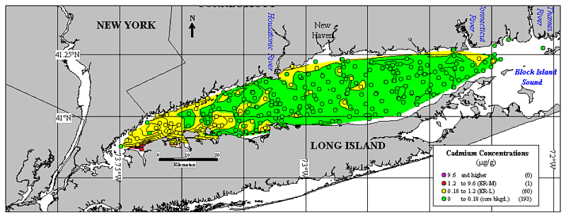
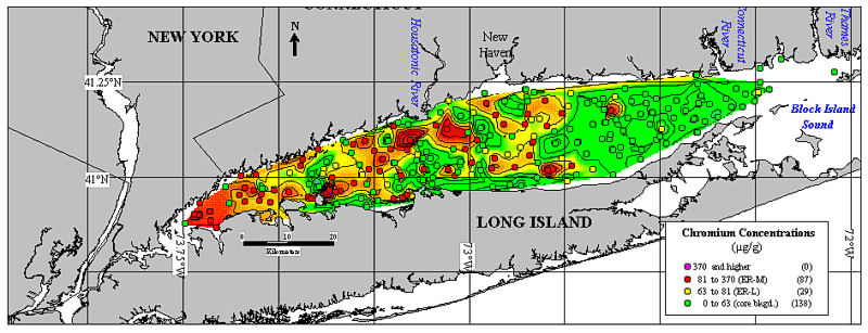
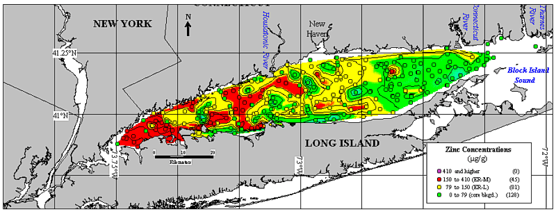
The distribution maps of Pb (Fig. 7) and Cu (Fig. 5) concentrations are grouped into ranges that are defined by the natural background values, which were measured in regional sediment cores (see Tables 2 and 3), and by the potential to induce toxic effects in macrobenthos (Long and others (1996, 1998). Long and others (1996, 1998) use two sediment quality criteria, the Effects Range-Low (ER-L) and the Effects Range-Medium (ER-M), to define the potential for the metal concentrations in sediments to induce toxicity. The concentration ranges outlined in the methods were also used to calculate the degree of metal enrichment (Tables 2 and 3). Pb and Cu are enriched in the whole Sound and have mean concentrations that exceed their ER-Ls. The high anthropogenic metal concentrations in the western and central basins of the Sound generally exceed these sediment criteria, which provide a warning of potential toxic effects in macrobenthos exposed to these sediments.
Throughout the Sound, higher values of the anthropogenic elements were found in samples with a high percentage of fine-grained sediment than in samples in sandier regions (Salomons and Forstner, 1984; Buckley and Cranston, 1991). The high concentrations of metals in the central and western basins, and the absence of enrichment in the sandy eastern Sound and the axial depression, indicate that fine-grained sediments, and the contaminants associated with them, are focused in the basins by current activity. The concentration distributions of these elements follow patterns that correlate with the sedimentary environments (Knebel and Poppe, in press and this CD-ROM), the sediment texture and TOC ( Poppe and others, in press and this CD-ROM), and the Clostridium perfringens spore concentrations (Buchholtz ten Brink and Mecray, 1998; Buchholtz ten Brink and others, in press). The distributions of Pb (Fig. 7), Cu (Fig. 5) and the other anthropogenic elements (Figures 2-8) are also similar to the patterns of bottom stress generated by the hydrodynamic regime in that areas of high concentration are found in basins where winnowing by current and tidal activity is minimal (Signell and others, in press).
Concentrations are low in the eastern Sound, the axial depression, and the shoal areas despite their proximity to nearshore contaminant sources. These low values correspond with the occurrence of predominantly coarse-grained sediment (Poppe and others, in press and this CD-ROM), non-depositional environments (Knebel and Poppe, in press), and high bottom stress generated by the local hydrodynamic regime (Signell and others, 1998, in press). Low metal concentrations are measured on the shoal complexes and in the axial depression where, when winds blow parallel to the axis of the Sound, the currents are stronger which winnows the fine-grained, metal-bearing particles and deposits them in the relatively quiescent basins (Signell and others, in press).
In addition to the sedimentary environment and the hydrodynamic regime,
the distribution of anthropogenic metal concentrations in Long Island Sound
surface sediments is also affected by the proximity to contaminant sources.
Within the Sound, particulates and associated contaminants exist as suspended
material which becomes homogenized and dispersed (Kim and Bokuniewicz,
1991). After solids and associated metals sink towards the bottom,
they are transported by the net westerly bottom flow (Signell and others,
in press), which traps the sediments in the western end. Anthropogenic
sources of metals are greater in the central and western regions than elsewhere
in the Sound (Grieg and others, 1977; Strategic Assessments Branch, 1990;
Breault and Harris, 1997; Buchholtz ten Brink and others, in press and
this CD-ROM). Metal loadings in the western Sound originate from
direct discharge and industrial effluent from the largest metropolitan
region of the United States (Farrow and others, 1986; Benoit and others,
1999). The combined effects of population density in the western Sound,
point and non-point sources in the region, the general transport of contaminant-bearing
fine-grained material, and the location of depositional areas yield the
contaminant concentration patterns that are observed in the Sound.
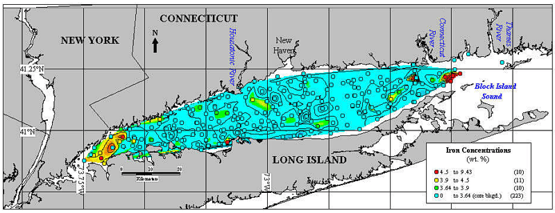
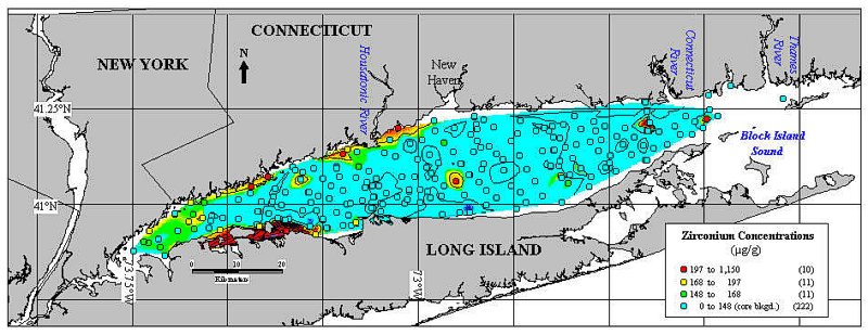
Four samples from the scoured, eastern Sound had concentrations of Mn,
Fe, V, Ti, and Zn, that were more than ten times greater than elsewhere
in the Sound. An explanation for the elevated concentrations of these
elements in the easternmost Sound may be the presence of local sources
or lag deposits containing these elements. Major elements, particularly
Fe and Mn, are found in steel manufacturing (Farrow and others, 1986).
Zn is used in the metal industry and also as a component of rubber tires
(Nriagu, 1980). Both point and non-point sources are likely to affect
the distribution of these elements over a broad area of the Sound.
Diagenic metals, such as Fe, Mn, Ti, and V, may accumulate in the sediments
as oxide crusts formed in the presence of high water volumes flowing across
the surface sediments in the eastern Sound. Such oxide crusts may
be a recent addition to the Sound, or they may be the result of a relict
lag deposit (Mecray and Buchholtz ten Brink, in press).
The regional patterns of metal concentrations in Long Island Sound result
primarily from variations in bottom energy that result in differing grain
sizes and particle lithology for the sedimentary environments. The
anthropogenic metals are widely dispersed in Long Island Sound and are
subject to redistribution in some regions. Their distributions co-vary
with the texture, the sedimentary environments, and the lithology of the
sequestering material (Fe, Al, or TOC) measured in the sediments.
Blackwood, D.B. and Parolski, K.F., 2000, "Seaboss": An elegantly simple image and sampling system: Proceedings of the Sixth International Conference on Remote Sensing for Marine Environments, Veridian ERIM International, v. 1, p. 99-106.
Breault, R.F. and Harris, S.L., 1997, Geographical distribution and potential for adverse biological effects of selected trace elements and organic compounds in streambed sediment in the Connecticut, Housatonic, and Thames River Basins, 1992-1994: U.S. Geological Survey Water-Resources Investigations Report 97-4169, 24 p.
Buchholtz ten Brink, M.R. and Mecray, E.L., 1998, Chapter 5 In: L.J. Poppe and C. Polloni (eds.), Long Island Sound Environmental Studies, U.S. Geological Survey Open-File Report 98-502, 1 CD-ROM.
Buchholtz ten Brink, M.R., Mecray, E.L., and Galvin, E.L., in press, Clostridium perfringens in Long Island Sound sediments: An urban sedimentary record:. Journal of Coastal Research, Thematic Section.
Buckley, D.E. and Cranston, R.E., 1991, The use of grain size information in marine geochemistry,. In: J. P. M. Syvitski (ed.), Principles, Methods, and Application of Particle Size Analysis. New York: Cambridge University Press, p. 311-331.
Farrow, D.R.G., Arnold, F.D., LombardiI, M.L., Main, M.B., and Eichelberger, P.D., 1986, The National Coastal Pollutant Discharge Inventory: Estimates for Long Island Sound. Rockville, MD: National Oceanic and Atmospheric Administration, Selected Appendices (II-VIII), 74 p.
Grieg, R.A., Reid, R.N., and Wenzloff, D.R., 1977, Trace metal concentrations in sediments from Long Island Sound: Marine Pollution Bulletin, v. 8, p. 183-188.
Jenne, E.A., 1998, Adsorption of Metals by Geomedia: Variables, Mechanisms, and Model Applications: Boston, Academic Press, 583 p.
Kim, B.H. and Bokuniewicz, H.J., 1991, Estimates of sediment fluxes in Long Island Sound: Estuaries, v. 14, p. 237-247.
Knebel, H.J. and Poppe, L.J., in press. Sea-floor environments within Long Island Sound: A regional overview: Journal of Coastal Research, Thematic Section.
Long, E.R., Robertson, A., Wolfe, D.A., Hameedi, J.W., and Sloane, G.M., 1996, Estimates of the spatial extent of sediment toxicity in major U.S. estuaries: Environmental Science and Technology, v. 30, p. 3585-3592.
Long, E.R., Field, L.J., and MacDonald, D.D., 1998, Predicting toxicity in marine sediments with numerical sediment quality guidelines: Environmental Toxicology and Chemistry, v. 17, p. 714-727.
MapInfo Corporation, 1998, MapInfo Professional, Version 5.0, Troy, NY.
Mecray, E.L. and Buchholtz ten Brink, M.R., in press. Contaminant distribution and accumulation in the surface sediments of Long Island Sound: Journal of Coastal Research, Thematic Section.
Murray, R.W. and Leinen, M., 1996, Scavenged excess Al and its relationship to bulk Ti in biogenic sediment from the central equatorial Pacific Ocean: Geochimica et Cosmochimica Acta, v. 60, p. 3869-3878.
Northwood Geoscience Ltd., 1999, Vertical Mapper, version 2.5. Northwood Geoscience Ltd., Nepean, Ontario, Canada.
Nriagu, J.O. (ed.), 1980, Zinc in the Environment, Part I: Ecological Cycling. In: R.L. Metcalf and W. Stumm (eds.), Wiley Interscience Series of Texts and Monographs: New York, John Wiley and Sons, p. 453.
Poppe, L.J., Hastings, M.E., DiGiacomo-Cohen, M.L., Manheim, F.T., and Mlodzinska, Z.J., 1998, Surficial sediment database, In L.J. Poppe and C. Polloni, Long Island Sound Environmental Studies: U.S. Geological Survey Open-File Report 98-502, Chapter 3, CD-ROM.
Poppe, L.J., O'Leary, D.W., and Commeau, R.F., 1985, Composition and morphology of ferromanganese coatings on glacial erratics in Lydonia Canyon, United States east coast: Geo-Marine Letters, v. 5, p. 127-133.
Poppe, L.J., Knebel, H.J., Mlodzinska, Z.L., Hastings, M.E., and Seekins, B.A., in press, Distribution of surficial sediment in Long Island Sound and adjacent waters: Texture and total organic carbon: Journal of Coastal Research, Thematic Section.
Potter, H.A.B. and Yong, R.N., 1999, Influence of iron/aluminum ratio on the retention of lead and copper by amorphous iron-aluminum oxides: Applied Clay Science, v. 14, p. 1-26.
Salomons, W. and Forstner, U., 1984, Metals in the Hydrocycle: New York: Springer Verlag, 349 p.
Signell, R.P., Knebel, H.J., List, J.H., and Farris, A.S., 1998, Physical processes affecting the sedimentary environments of Long Island Sound, In: M. Spaulding and A.F. Blumberg (eds.), Proceedings of the 5th International Conference on Estuarine and Coastal Modeling: New York: American Society of Civil Engineers, p. 400-412.
Signell, R.P., List, J.H., and Farris, A.S., in press, Bottom currents and sediment transport in Long Island Sound: A modeling study: Journal of Coastal Research, Thematic Section.
Strategic Assessments Branch, 1990, Estuaries of the United States: Vital statistics of a national resource base. Rockville, Maryland: National Oceanic and Atmospheric Administration, National Ocean Service, Ocean Assessments Division, 40 p.
Varekamp, J.C., Buchholtz ten Brink, M.R., and Mecray, E.L., in press, Mercury in Long Island Sound sediments: Journal of Coastal Research, Thematic Section.
Visser, K., 1999, Chemical Concentrations in Sediment from Long Island
Sound: Relationships to Grain Size: B.S. Senior Thesis, Boston University,
Boston, Massachusetts, 55 p.
Figure 2. Silver (Ag) concentrations (µg/g dry sediment) in the surface sediments (0-2 cm) of Long Island Sound. The upper divisions on the legend are defined by the Effects Range-Low (ER-L) and Effects Range-Medium (ER-M) sediment quality guidelines of Long and others (1996, 1998). The low range is defined by the natural background values observed in sediment cores from western Long Island Sound. Purple dots represent concentrations measured above the ER-M for Ag in sediments. Red dots represent samples above the ER-L, but below the ER-M. Yellow dots are concentrations below the ER-L, but above the natural background concentrations. The green circles are concentrations that are below naturally-occurring values for Ag, as measured in fine-grained, regional sediment cores (see Table 2 and 3).
Figure 3. Cadmium (Cd) concentrations (µg/g dry sediment) in the surface sediments (0-2 cm) of Long Island Sound. Concentration ranges used on the map are determined by the sediment quality guidelines of Long and others (1996, 1998) for Cd. Natural background values for Cd are presented in Table 2. The distributions of silver (Ag; Fig. 2), chromium (Cr; Fig. 4), copper (Cu; Fig. 5), and mercury (Hg; Fig. 6) are similar to this Cd distribution.
Figure 4. Chromium (Cr) concentrations (µg/g dry sediment) in the surface sediments (0-2 cm) of Long Island Sound. Concentration ranges used on the map are determined by the sediment quality guidelines of Long and others (1996, 1998) for Cr. Natural background values for Cr are presented in Table 2.
Figure 5. Copper (Cu) concentrations (µg/g dry sediment) in the surface sediments (0-2 cm) of Long Island Sound. Concentration ranges used on the map are determined by the sediment quality guidelines of Long and others (1996, 1998) for Cu. Natural background values for Cu are presented in Table 2.
Figure 6. Mercury (Hg) concentrations (ppb dry sediment) in the surface sediments (0-2 cm) of Long Island Sound. Concentration ranges used on the map are determined by the sediment quality guidelines of Long and others (1996, 1998) for Hg. Natural background values for Hg are presented in Table 2.
Figure 7. Lead (Pb) concentrations (µg/g dry sediment) in the surface sediments (0-2 cm) of Long Island Sound. Concentration ranges used on the map are determined by the sediment quality guidelines of Long and others (1996, 1998) for Pb. Natural background values for Pb are presented in Table 2.
Figure 8. Zinc (Zn) concentrations (µg/g dry sediment) in the surface sediments (0-2 cm) of Long Island Sound. Concentration ranges used on the map are determined by the sediment quality guidelines of Long and others (1996, 1998) for Zn. Natural background values for Zn are presented in Table 2.
Figure 9. Aluminum (Al) concentrations (weight %) in the surface sediments (0-2 cm) of Long Island Sound. Blue dots represent samples below the natural background value measured in sediment cores taken from Long Island Sound. All other concentration ranges were determined by an equal spread in the values.
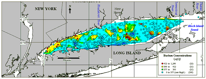
Figure 10. Barium (Ba) concentrations (weight %) in the surface sediments (0-2 cm) of Long Island Sound. Concentration ranges used on the map are determined by the same criteria as in Figure 9.
Figure 11. Iron (Fe) concentrations (weight %) in the surface sediments (0-2 cm) of Long Island Sound. Concentration ranges used on the map are determined by the same criteria as in Figure 9. The elevated concentrations in the eastern Sound are samples that contain oxide coatings.
Figure 12. Nickel (Ni) concentrations (µg/g dry sediment) in the surface sediments (0-2 cm) of Long Island Sound. The upper concentration ranges used on the map are determined by the sediment quality guidelines of Long and others (1996, 1998) for Ni. The lower concentration ranges are determined by an equal spread in the values since the ER-L exceeded the natural background values found in Long Island Sound.
Figure 13. Titanium (Ti) concentrations (weight %) in the surface sediments (0-2 cm) of Long Island Sound. Concentration ranges used on the map are determined by the same criteria as in Figure 9.
Figure 14. Vanadium (V) concentrations (µg/g dry sediment) in the surface sediments (0-2 cm) of Long Island Sound. Concentration ranges used on the map are determined by the same criteria as in Figure 9.
Figure 15. Zirconium (Zr) concentrations (µg/g dry sediment) in the surface sediments (0-2 cm) of Long Island Sound. Concentration ranges used on the map are determined by the same criteria as in Figure 9.
Figure 16. Calcium (Ca) concentrations (weight %) in the surface sediments (0-2 cm) of Long Island Sound. Concentration ranges used on the map are determined by the same criteria as in Figure 9.
Figure 17. Manganese (Mn) concentrations
(µg/g dry sediment) in the surface sediments (0-2 cm) of Long Island
Sound. Concentration ranges used on the map are determined by the same
criteria as in Figure 9.
Table 2. Summary statistics for the surface samples collected around Long Island Sound from 1996-1999. A copy of this table (chemtab2.xls) may also be downloaded in Microsoft Excel format.
Table 3. Summary statistics grouped by sedimentary environment (Knebel and Poppe, in press) for the surface samples collected by the U.S. Geological Survey in Long Island Sound. A copy of this table (chemtab3.xls) may also be downloaded in Microsoft Excel format.