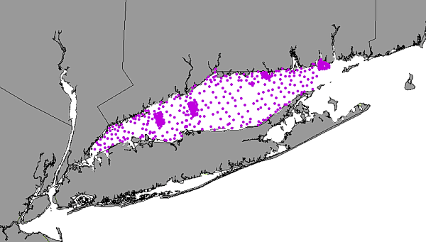
Title: Location of LIS samples with Total Organic Carbon (TOC)
Publication_Information:
Publication_Place: Woods Hole Field Center, Woods Hole, MA
Publisher: U.S. Geological Survey
Larger_Work_Citation:
Citation_Information:
Originator: Valerie Paskevich(ed.)
Originator: Larry Poppe(ed.)
Publication_Date: Unknown
Publication_Time: Unknown
Title:
Georeferenced Sea-Floor Mapping and Bottom Photography in Long Island Sound
Series_Information:
Series_Name: U. S. Geological Survey Open-File Report
Issue_Identification: OFR 00-304
Publication_Information:
Publication_Place: Woods Hole Field Center, Woods Hole, MA
Publisher: U. S. Geological Survey
Description:
Abstract:
This GIS layer contains a point overlay showing the location of samples
with Total Organic Carbon (TOC). This layer shows the distribution of samples
used in the creation of the TOC polygon layer, listoc.
Purpose:
The purpose of this data layer is to disseminate a digital version of the
map showing the locations of surficial total organic carbon sampling stations.
Time_Period_of_Content:
Time_Period_Information:
Range_of_Dates/Times:
Beginning_Date: 19920601
Ending_Date: 19980331
Currentness_Reference: Ground Condition
Status:
Progress: Complete
Maintenance_and_Update_Frequency: None planned
Spatial_Domain:
Bounding_Coordinates:
West_Bounding_Coordinate: -73.7482
East_Bounding_Coordinate: -72.1260
North_Bounding_Coordinate: 41.3439
South_Bounding_Coordinate: 40.8367
Keywords:
Theme:
Theme_Keyword_Thesaurus: General
Theme_Keyword: U.S. Geological Survey
Theme_Keyword: USGS
Theme_Keyword: Coastal and Marine Geology Team
Theme_Keyword: Coastal and Marine Geology Program
Theme_Keyword: Woods Hole Field Center
Theme_Keyword: Connecticut Department of Environmental Protection
Theme_Keyword: ArcView
Theme_Keyword: arcview
Theme_Keyword: shapefile
Theme_Keyword: points
Theme_Keyword: Total Organic Carbon
Theme_Keyword: TOC
Theme_Keyword: surficial sediments
Theme_Keyword: grain-size analysis
Theme_Keyword: distribution of surficial sediments samples
Theme_Keyword: surficial samples
Place:
Place_Keyword_Thesaurus: General
Place_Keyword: Long Island Sound
Place_Keyword: Connecticut
Place_Keyword: New York
Access_Constraints: None
Use_Constraints:
The U.S. Geological Survey must be referenced as the originator of the
dataset in any future products or research derived from these data.
Although this derived data set and its lineage dataset have been used
by the USGS, no warranty, expressed or implied, is made by the USGS as
to the accuracy of the data and/or related materials. The act of distribution
shall not constitute any such warranty, and no responsibility is assumed
by the USGS in the use of these data or related materials.
Attribute_Definition: Id is an ArcView internal parameter.
Attribute_Definition_Source: User Defined
Attribute_Domain_Values:
Range_Domain:
Range_Domain_Minimum: 0
Range_Domain_Maximum: 0
Unrepresentable_Domain: Character field
Overview_Description:
Entity_and_Attribute_Overview:
This data layer (total organic carbon sampling stations) shows the locations
from which these data are available.
Entity_and_Attribute_Detail_Citation:
Distribution of surficial sediment in Long Island Sound and adjacent waters:
texture and total organic carbon, by Poppe and others
Distribution_Information:
Distributor:
Contact_Information:
Contact_Organization_Primary:
Contact_Organization: U. S. Geological Survey
Contact_Person: Larry Poppe
Contact_Address:
Address_Type: mailing and physical address
Address: 384 Woods Hole Road
City: Woods Hole
State_or_Province: MA
Postal_Code: 02543-1598
Country: USA
Contact_Voice_Telephone: (508)548-8700 x2314
Contact_Electronic_Mail_Address: lpoppe@usgs.gov
Resource_Description: Long Island Sound: tocpnt1.shp
Distribution_Liability:
Although this derived data set and its lineage dataset have been used
by the USGS, no warranty, expressed or implied, is made by the USGS as
to the accuracy of the data and/or related materials. The act of distribution
shall not constitute any such warranty, and no responsibility is assumed
by the USGS in the use of these data or related materials.
Standard_Order_Process:
Digital_Form:
Digital_Transfer_Information:
Format_Name: ARCV
Format_Information_Content:
tocpnt1.dbf
tocpnt1.shp
tocpnt1.shx
tocpnt1.avl
File_Decompression_Technique: No compression applied
Transfer_Size: 25Kbytes
Digital_Transfer_Option:
Offline_Option:
Offline_Media: CD-ROM
Recording_Capacity:
Recording_Density: 650
Recording_Density_Units: Mbytes
Recording_Format: ISO 9600
Compatibility_Information:
The user must have a system with a CD-ROM capable of reading an ISO-9660
standard CD-ROM disk. To browse the information contained on this disk,
the user must also have a current version of a WWW browser available.
Digital_Form:
Digital_Transfer_Information:
Format_Name: ARCV
Format_Information_Content:
The four ArcView files (tocpnt1.dbf, tocpnt1.shp, tocpnt1.shx, tocpnt1.avl)
comprising a GIS layer showing the distribution of TOC samples used to
create the polygon layer, listoc.
File_Decompression_Technique: zip
Transfer_Size: 11Kbytes
Digital_Transfer_Option:
Offline_Option:
Offline_Media: CD-ROM
Recording_Capacity:
Recording_Density: 650
Recording_Density_Units: Mbytes
Recording_Format: ISO 9600
Compatibility_Information:
The user must have a system with a CD-ROM capable of reading an ISO-9660
standard CD-ROM disk. To browse the information contained on this disk,
the
user must also have a current version of a WWW browser available. The user
must also have the software installed on their computer system capable
to unzip the archived file.
Fees: none
Custom_Order_Process: Not available
Technical_Prerequisites:
The tocpnt1 layer is available in an ArcView shapefile format. The user
must have ESRI's ArcView 3.0 or greater software to read and process the
data file. In lieu of Arcview, the user may utilize another GIS application
package capable of importing the data.