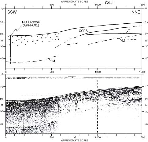
| Figure 4.4. ORE Geopulse Profile C9-1 extending northeast from MD99-2209 core site (bottom) and geologic interpretation (top). The dashed downward extension of the solid line representing the core represents sediment penetrated but not recovered, on the assumption that the core barrel continued without recovery after the recovered sediment had filled the barrel, and provided there was no sediment compaction. At the other extreme, if the dashed line represents the amount of compaction in the recovered core, the lowest sediment recovered was originally at the bottom of the dashed line, i.e. at 49 m bsl. "M" denotes surface-bottom multiples, and "T" is a Tertiary-aged reflector. |
TO RETURN TO REPORT, CLOSE THIS WINDOW.
U.S. Department of Interior, U.S. Geological Survey
URL of this page: https://pubs.usgs.gov/openfile/of00-306/chapter4/fig4-4.html
Maintained by: Eastern Publications Group Web Team
Last modified: 03.28.01 (krw)