
Digital Mapping Techniques '00 -- Workshop Proceedings
U.S. Geological Survey Open-File Report 00-325
The U.S. Geological Survey's Revision Program for 7.5-Minute Topographic Maps
By Larry Moore
U.S. Geological Survey
Mid-Continent Mapping Center
1400 Independence Road, MS 509
Rolla, MO 65401
Telephone: (573) 308-3661
Fax: (573) 308-3652
e-mail: lmoore@usgs.gov
ABSTRACT
The 1:24,000-scale, 7.5-minute topographic quadrangle is the primary product of the U.S. Geological Survey's (USGS) National Mapping Program. This map series includes about 53,000 map sheets for the conterminous United States and is the only uniform map series that covers this area at such a large scale. The 7.5-minute mapping program lasted almost 50 years, from the mid-1940's until the early 1990's, and consisted of new mapping. New aerial photographs were taken, field control was obtained, and field-based photointerpretation was done for every quadrangle. Feature names were verified by personal contacts with local residents and local government agencies.
Various processes are used to revise these maps. Some revisions use traditional analog processes, some use digital processes; some work is done by USGS employees, some by contractors. There are four main categories of map revision: minor, basic, complete, and single edition. Minor revision is done on maps that have few changes since the last revision; it includes boundary updates and corrections of previously reported errors. Basic revision updates features from digital orthophoto quadrangles (DOQ) and aerial photographs. Contour update is an optional part of basic revision and is not often done because of the high cost. Complete revision of all layers is seldom performed because of the high cost. Single-edition revisions are done by the U.S. Department of Agriculture Forest Service using procedures similar to basic revision.
The current revision program was not designed to do replacement mapping. Most map revision is done from remote and secondary data sources, including the following:
- Geometry is controlled and some feature content interpreted from DOQ's.
- Most feature content is interpreted by using stereophotographs from the National Aerial Photography Program.
- Boundary and name information is collected from Federal databases, other maps, and State and local agencies.
- Some content may be field checked by Earth Science Corps volunteers (private citizens who donate time to do field verification work) or by State agencies participating in cooperative mapping projects.
INTRODUCTION
In 1989, the Mapping Science Committee of the National Research Council wrote that "...the primary product [of the U.S. Geological Survey (USGS) National Mapping Division (NMD)] is the 1:24,000, 7.5-minute topographic quadrangle series. This...is the only uniform map series that covers the entire area of the [continental] United States in considerable detail. The series will be completed in 1990...NMD's principal raison d'etre is changing to the equally challenging task of maintaining currency of these maps...A major ongoing revision effort, which NMD is now pursuing, is required" (National Research Council, 1990, p. 8).
The USGS produces printed maps and digital map data for all States, possessions, and territories of the United States, and Antarctica. This paper discusses only the 1:24,000- and 1:25,000-scale topographic maps in the 48 continental United States. There are 54,890 standard 7.5-minute and 7.5- by 15-minute cells in this domain.
Because the two cell sizes overlap, the number of map sheets has varied with time. At present, there are 53,336 map sheets that cover the continental United States. Both cell sizes and scales are referred to in this paper as "7.5-minute maps" or "7.5-minute quadrangles."
The 7.5-minute maps are more detailed versions of other quadrangle series that date back to the formation of the USGS in 1879 (Schwartz, 1980, p. 311). Although 7.5-minute maps were produced by the USGS as early as 1908, the effort to cover the country at this scale was a product of World War II technological advances and 1939 legislation creating a National Mapping Program (Bohme, 1989, p. 167). Initial coverage of 7.5-minute maps in the continental United States is summarized in figure 1. The program grew rapidly from 1945 through 1955, then more slowly, and peaked in 1973. In the early 1980's, it became evident that production rates were not sufficient to finish the series before the year 2000. Beginning in 1982, manuscript maps without final cartographic finishing were published (Bohme, 1989, p. 167). These were designated "provisional maps" (P-maps). A significant production increase in the mid-1980's resulted from the lower cost of provisional mapping (fig. 1). Most of the work on the 7.5-minute maps was finished by 1990, and the series was officially declared complete in 1992.
Figure 1. Original production of 7.5-minute quadrangles. Each data point is the number of quadrangles published in a particular year. Each cell is shown only once, the first time a map for the cell was made. The median date of printing is 1972. The smooth gray curve is a polynomial trendline. The data for this and the other figures in this report are from National Mapping Division databases, including the map catalog (MAPCAT) and the assignment management system (AMS).
|
MAP REVISION PROGRAMS AND METHODS
7.5-minute maps have been revised almost from the beginning of the program, but revision numbers did not become significant until the mid-1960's (fig. 2). To speed up the revision of existing map sheets, an interim revision was introduced in 1967 (Bohme, 1989, p. 167). Commonly called photorevision, this remained the most common type of revision through the 1980's. The original map base was used as horizontal control, and new features were collected from stereophotographs without field verification. Contours usually were not revised. To show that the revision did not meet new mapping standards for control and field verification, new photorevised features were printed on the maps in purple.
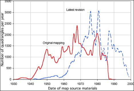
Figure 2. Currentness of revised maps compared to original maps. The solid line is identical to that in Figure 1, except it is shifted 5 years to the left to show average date of content rather than date of printing. The dashed line shows the date of content for the most recent revision of each cell. For example, 1981 is the source photography date for the most recent revision of about 3,000 quadrangles. The median currency date for original mapping is 1967; the median for latest revisions is 1979. The data include minor revisions but not maps reprinted �as is� to replace low shelf stock.
|
With the completion of the 7.5-minute mapping program in 1992, the USGS began formulating a graphic revision plan to keep primary series maps current. Decisions about revising 7.5-minute quadrangles are based on user requirements, available resources, and the preferences of funding cooperators. Accuracy assessments, evaluations of existing quadrangle materials, and error reports are also considered. Two primary drivers of the NMD revision program are listed below.
- Cooperative funding from other agencies. The USGS will divide revision costs equally with other State or Federal agencies.
- A list of 5,000 "high seller" maps. These maps are judged to be most in demand and are given priority for revision work. A percentage of these maps are revised each year with or without cooperative funding.
Revision decisions are also constrained by other factors. The most important of these is the availability of recent aerial photography and digital orthophoto quadrangles (DOQ) for the quadrangle under consideration.
Figure 2 shows the overall currentness of the 7.5-minute maps at the end of 1999. The median currency date for the series as a whole is 1979, so the average 7.5-minute map is almost exactly 20 years old. The data in this figure include all photorevisions and minor revisions but not maps reprinted "as is" to replace low shelf stock. The curve falls rapidly toward zero as it approaches the year 2000, but this does not indicate that the revision program is dying. Aerial photographs and other source materials used for map revision are usually 3 to 5 years old by the time the map is published, so most maps printed in 1999 appear in the years 1994 to 1996 in figure 2.
There are currently four official types of map revision: minor revision, basic revision, complete revision, and single-edition revision. The first three are defined by USGS product standards, the fourth by an interagency agreement with the U.S. Department of Agriculture Forest Service (FS). Numbers of each type of revision produced from 1996 to 2000 are shown in figure 3.
Figure 3. Currentness of revised maps compared to original maps.
|
Minor Revision
Revision candidate quadrangles are compared to recent aerial photographs to determine how much change has occurred since the last map revision. If changes are small and few in number, the map may need only minor revision. Names and boundaries are updated using information from local sources and other maps. Corrections on file are made and the map collar is updated.
Basic Revision
Basic revision uses aerial photographs from the National Aerial Photography Program (NAPP) to update a subset of map features. DOQ's made from NAPP photographs are the primary data source. The DOQ's are used for horizontal position control and for feature interpretation. Stereopairs of the same NAPP photographs aid feature interpretation. In some cases, field checks may be performed by volunteers or by State cooperating agencies. Name, boundary, and collar updates are similar to minor revision. Basic revisions may or may not include contour updates.
Even though it depends almost entirely on remote sources, basic revision is not cheap. Basic revisions done with USGS Government labor in 1998 and 1999 required an average of 280 hours per quadrangle, or approximately $17,000. Although costs for contractor-produced revisions in 1999 were comparable, they are expected to decrease as contractors gain experience with USGS standards.
Complete Revision
Complete revision updates all standard feature content, including contours. Information is field checked. This is very expensive and is therefore rarely done. Only four USGS quadrangles were completely revised between 1995 and 2000. Complete revision of these four was possible because a State agency did the field verification work.
Single Edition
In 1993, the USGS and the U.S. Forest Service (FS) signed an interagency agreement to begin a joint single-edition mapping program. The content of the maps includes the features normally shown on USGS maps, with additional features required for the management of National Forest System land. Under the agreement, 7.5-minute quadrangles that contain National Forest land are revised by the FS but are printed and distributed by the USGS. There are about 10,000 7.5-minute single-edition map cells. Procedures for single-edition updates are controlled by the FS and are similar to USGS basic revision procedures. The interagency agreement allows the FS to update only the National Forest land on a quadrangle and leave the other areas of the map unrevised. In these cases, the remainder of the map is part of the USGS revision pool. The two organizations have different requirements and criteria for selecting maps for revision, so revision of forest and non-forest land is usually not concurrent.
DATA SOURCES
The current USGS revision program was not designed to do replacement mapping. Most revision work is done using remote and secondary sources, including the original map, recent aerial photographs, information from other maps, and information from other Government agencies. Following are the major sources of data.
Aerial Photographs and Digital Orthophotos
DOQ's are the most critical input to basic revision. They are made using horizontal control that is usually independent of the topographic map, and the average USGS DOQ is positionally more accurate than the average topographic quadrangle. An objective of basic revision is, therefore, to make the revised map match the DOQ. Major planimetric features, especially roads and buildings, can be collected directly from a DOQ in computer-aided drafting software systems.
DOQ's are made from NAPP photographs, and basic revision compilers also use stereopairs of the original photographs to assist with feature interpretation. The current NAPP plan calls for full coverage of the continental United States in 7 years (1997-2003). This schedule is subject to availability of funding, including State cooperative funding (U.S. Geological Survey, 1996).
It is not necessarily the case that a DOQ made from the most recent photography exists. The NAPP, the DOQ program, and the map revision program are not closely coupled; each has its own customer base and its own funding sources. Nonavailability of recent aerial photographs, a recent DOQ, or the control needed to make a DOQ can make it impossible to revise a particular map.
The photographs for the original 7.5-minute program usually had scales that range from 1:15,000 to 1:25,000. The NAPP photographs used for revision have an average scale of approximately 1:40,000. The smaller scale has some effects on the accuracy of the revision, especially on contour updates.
Other Government Agencies
The USGS depends on other agencies for some types of data, particularly boundaries. When a map is authorized for revision, requests for up-to-date boundary information are sent to Federal, State, and local government agencies. The elapsed time between requesting and receiving these data can be a significant factor in the total time required to revise a map.
State agencies participating in cooperative mapping projects may also elect to do field verification work to improve the accuracy and completeness of the map content.
Geographic Names Information System
The Geographic Names Information System (GNIS) database is the official repository of feature names for the United States. Names and feature locations are checked against the GNIS and changes are included on every topographic map revision.
Earth Science Corps
The USGS has a volunteer program that allows private citizens to contribute to the earth science mission of the agency. The Earth Science Corps is the field component of the volunteer program, and it includes an ongoing map annotation project where volunteers collect new information to be used in the National Mapping Program. As of October 1999, about 3,100 quadrangles had been assigned to 2,400 volunteers.
CONTOUR UPDATES
Elevation contour lines are the signature feature of USGS topographic maps. Much of the other information on a 7.5-minute map can be found on other types of maps, but until the recent development of airborne laser and radar ranging technologies, there were no other sources of elevation data with comparable coverage and accuracy.
The USGS map revision programs have always assumed that topography is much more stable than planimetry. A new road or subdivision disturbs the land surface slightly, but rarely is the disturbance enough to warrant major revision of contour lines with 10-, 20-, or 40-foot intervals. The current map revision program is explicitly tied to DOQ's, and contours cannot be revised from these monoscopic images.
Basic revision follows these guidelines for revising contours:
- Contours are revised only as part of joint funding agreements; that is, only when another agency is willing to share the cost. Revising contours can increase the cost of a revision by 50 to 100 percent.
- The contour overlay is not completely recompiled but rather is updated in areas of significant topographic change. The original map base is used for vertical control.
- In areas of insignificant topographic change, "logical contouring" is used to preserve registration with other features. For example, contours are squared across new roads and routed around new ponds without stereorecompilation.
Contours are revised with NAPP stereophotographs, which are usually smaller scale than the photographs used to compile the original contours. Therefore, improving the accuracy of existing contours is usually not possible except in areas of very significant surface disturbance. This is consistent with the overall objectives of the revision program, which are to maintain the horizontal and vertical accuracy of the existing map.
Most basic revisions do not include contour updates (fig. 3), which means that the topography and planimetry on the revised graphic have different currentness dates. In some cases, this leads to glaring visual artifacts, such as contour lines in large water bodies or new islands with no topography.
ACCURACY OF REVISED MAPS
The USGS originally compiled topographic maps using procedures designed to meet the National Map Accuracy Standards (NMAS). Basic revision procedures were originally designed to retain the accuracy of the existing map but not necessarily to improve it. This objective has shifted in the last 2 years, and now the horizontal accuracy goals of basic revision are that the revised map should be at least as accurate as the previous version and that all features should match the DOQ to within at least 73 feet. Both goals are evaluated by statistically comparing the map to the DOQ.
Contours and spot elevations also were originally compiled to meet the NMAS. At present, the USGS has no testing program to systematically evaluate the vertical accuracy of either the original or revised map. When there is some external reason to believe that contours may not meet NMAS, attempts are made to evaluate the data against independent and higher order control. Significantly improving the quality of contour data is extremely difficult because of the nonavailability of large-scale aerial photographs and vertical control that is independent of the original map base.
CONCLUSIONS
Although as many as 1,500 7.5-minute quadrangles per year are being revised, none of these are complete revisions. Very few revisions include contour updates, new control, or field verification of content.
Map revision standards and procedures currently in place will be used for at least several more years. The USGS has no specific plans to return to a program of new mapping by collecting new control and doing new field verification. In order to revise a greater number of maps with available funding, topographic map revision will continue to be done with remote and secondary sources for the foreseeable future.
RELEVANT WEB SITES
For further information, please consult these web sites:
REFERENCES
Bohme, Rolf, 1989, Inventory of World Topographic Mapping. Published on behalf of the International Cartographic Association by Elsevier Applied Science Publishers.
National Research Council, 1990, Spatial Data Needs: The Future of the National Mapping Program: National Academy Press, Washington, D.C., 88 p.
Schwartz, S.I. and Ehrenberg, R.E, 1980, The Mapping of America: New York, H.N. Abrams.
U.S. Geological Survey, 1996, The National Aerial Photography Program (NAPP): U.S. Geological Survey, 2 p. [fold out brochure].
U.S.Department of the Interior, U.S. Geological Survey
<https://pubs.usgs.gov/openfile/of00-325/moore.html>
Maintained by Dave Soller
Last updated 11.01.00