|
1U.S. Geological Survey 908 National Center Reston, VA 20192 Telephone: (703) 648-6907 Fax: (703) 648-6937 e-mail: drsoller@usgs.gov |
2U.S. Geological Survey 345 Middlefield Rd, MS 951 Menlo Park, CA 94025 Telephone: (650) 329-5061 Fax: (650) 329-5051 e-mail: tlnquist@usgs.gov |
From May 19 through September 15, 2000, the Federal Geographic Data Committee's Geologic Data Subcommittee is conducting a public review of a proposed digital cartographic standard for geologic map symbolization. [The Geologic Data Subcommittee of the Federal Geographic Data Committee (FGDC) is responsible for coordination of geologic data-related activities among Federal agencies. The Subcommittee promotes the collection, use, sharing, and dissemination of geologic map information.] Comments and guidance are welcomed from all interested parties including members of the general public, private companies and consultants, state geological surveys, and other government agencies. After the public review, all comments will be considered and the draft will be revised accordingly. If all comments have been addressed to the FGDC's satisfaction, the revised draft then will be approved as a Federal standard.
If approved by the FGDC following the public review period, this draft standard will apply to geologic-map information published by the Federal government in both offset-print and plot-on-demand formats. It also is suitable for use in electronic publications (for example, in a Portable Document Format (PDF) file) and for display by computer monitors. Non-Federal agencies and private companies that produce geologic-map information are urged to adopt this standard as well.
Table 1. Preparers of This Draft Standard. Unless otherwise noted, each individual contributed to both
the Working Draft and the Public Review Draft.
|
David R. Soller (USGS; Chief, National Geologic Map Database)--Coordinator, FGDC draft standard development.
Taryn A. Lindquist (USGS; Digital Map Specialist, Western Publications Group)--Editor and compiler, FGDC draft standard document; coordinator, PostScript and ArcInfo implementations; designer, line symbols for PostScript and ArcInfo implementations. Sara Boore (USGS; Publication Graphics Specialist, Western Publications Group)--Designer, FGDC draft standard document, point and line symbols, color charts and patterns for PostScript implementation. F. Craig Brunstein (USGS; Geologic Map Editor, Central Publications Group)--Technical reviewer, FGDC Working Draft. Alessandro J. Donatich (USGS; Geologic Map Editor, Central Publications Group)--Technical reviewer, FGDC Working Draft. Kevin Ghequiere (USGS; Cartographer, Western Publications Group)--Designer, patterns for PostScript implementation. Richard D. Koch (USGS; Digital Map Specialist, Western Publications Group)--Designer, point symbols for ArcInfo implementation, geologic age symbol font. Diane E. Lane (USGS; Geologic Map Editor, Central Publications Group)--Technical reviewer, FGDC Working Draft. Susan E. Mayfield (USGS; Publication Graphics Specialist, Western Publications Group)--Designer, FGDC draft standard document, color charts and patterns for PostScript implementation. Kathryn Nimz (USGS; Digital Map Specialist, Western Publications Group)--Designer, patterns for PostScript and ArcInfo implementations. Glenn Schumacher (USGS; Publication Graphics Specialist, Western Publications Group)--Designer, bar scales, mean declination arrows, and quadrangle location maps. Stephen L. Scott (USGS; Publication Graphics Specialist, Western Publications Group)--Designer, FGDC draft standard document, point symbols and line symbols for PostScript implementation. Will Stettner (USGS; Cartographer, Eastern Publications Group)--Technical reviewer, FGDC Working Draft. José F. Vigil (USGS; Motion Graphics Specialist, Western Publications Group) -- Designer, geologic age symbol font. Jan L. Zigler (USGS; Geologic Map Editor, Western Publications Group)--Technical reviewer, FGDC Working Draft. |
In 1995, a proposed standard was informally released by the USGS (U.S. Geological Survey, 1995). In 1996, this proposed standard was formally reviewed by geologists and cartographers in the USGS, the Association of American State Geologists (AASG), which represents the state geological surveys, and the FGDC's Geologic Data Subcommittee (GDS), which is composed mostly of representatives from Federal agencies that produce or use geologic map information. That review (Soller, 1996) indicated the need for some revision to the proposed standard prior to its consideration by the FGDC for adoption as a Federal standard.
In 1996, plans were outlined to create a revised and updated Federal standard, and the standards-development group was formed. A proposal to develop the revised standard was submitted by the FGDC's GDS (see http://ncgmp.usgs.gov/fgdc_gds/mapsymbprop.html), and the FGDC accepted that proposal in 1997. Later that year, the standards-development group produced a preliminary, beta version of the draft standard, which was circulated among selected USGS and state geological survey personnel for review. Comments were incorporated and, in 1999, the revised draft standard (Working Draft) was submitted to the FGDC's GDS for consideration. Upon review and subsequent approval by the GDS, the Working Draft was submitted to the FGDC Standards Working Group, which approved the document for public review, pending adoption of minor changes. The changes were made, and this new draft standard document (Public Review Draft) became available to the public for review and comment on May 19, 2000. The public review period will extend through September 15, 2000.
To help users maintain an up-to-date hard-copy version of the standard document, the initial release will be printed in "loose-leaf" format. Subsequent updates to the standard document will be made available in PDF format only, which could then be printed on a local output device and inserted where appropriate into a loose-leaf binder.
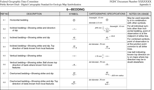
In this new draft standard, descriptions, examples, cartographic specifications, and notes on usage are provided for a wide variety of symbols (see for example, figure 1) that may be used on typical digital geologic maps or related products such as cross sections. In the preparation of this standard, every effort was made to retain the original symbols and their specifications from the 1995 USGS proposed standard (U.S. Geological Survey, 1995); however, many updates have been incorporated into this new version. The number of symbols has increased significantly, from about 800 to almost 1200. Symbols are more logically grouped; some sections have been combined with others, and a few new sections have been added. A newly revised chart that shows a wide range of CMYK colors has been included. An offset-print version of this chart has been in use at the USGS for many years, and the variety of colors has proved to be sufficient for portraying complex geology shown on most maps, regardless of the output medium. In addition, a chart that shows commonly used geologic patterns has been added. The patterns themselves are similar to what was in the 1995 USGS proposed standard, but most have undergone lineweight changes to facilitate digital output at high resolutions. Table 2 lists the contents of the standard.
Table 2. Contents of the Standard.
1. Contacts, Key Beds, and Dikes
5. Folds
7. Cleavage 8. Foliation
10. Paleontological Features
13. Glacial and Glaciofluvial Features 14. Periglacial Features 15. Lacustrine and Marine Features 16. Eolian Features 17. Landslide and Mass-Wasting Features 18. Volcanic Features 19. Natural Resources
21. Neotectonic and Earthquake-Hazard Features 22. Plate-Tectonic Features 23. Miscellaneous Uplift and Collapse Features 24. Terrestrial Impact-Crater Features 25. Planetary Geology Features 26. Hydrologic Features
28. Transportation Features 29. Boundaries 30. Topographic Features 31. Miscellaneous Map Elements 32. Pattern Chart (Plate B) 33. Suggested Stratigraphic-Age and Volcanic Map-Unit Colors
35. Bar Scales 36. Mean Declination Arrows
|
Because this new standard is intended for use with digital applications, an electronic implementation of the Public Review Draft has been prepared in PostScript format, and it is informally released as a USGS Open-File Report (U.S. Geological Survey, 1999 (http://geopubs.wr.usgs.gov/open-file/of99-430/). This PostScript implementation will enable reviewers to directly apply the standard to geologic maps or illustrations prepared in desktop illustration and (or) publishing software. As the formally approved standard evolves, the PostScript implementation will be updated as well. Additionally, partial work on an ArcInfo (v. 7x) implementation has been completed, and this implementation may also be informally released as a USGS Open-File Report in the future. Information regarding updates to these and other implementation efforts will be posted on FGDC's GDS website, http://ncgmp.usgs.gov/fgdc_gds/.
U.S. Geological Survey, ca. 1975, Technical cartographic standards volume: unpublished U.S. Geological Survey internal standards document.
U.S. Geological Survey, 1995, Cartographic and digital standard for geologic map information: U.S. Geological Survey Open-File Report 95-525, 257 p.
U.S. Geological Survey, 1999, Public review draft -- digital cartographic standard for geologic map symbolization (PostScript implementation), prepared in cooperation with the Geologic Data Subcommittee of the Federal Geographic Data Committee: U.S. Geological Survey Open-File Report 99-430, http://geopubs.wr.usgs.gov/open-file/of99-430/.