![]()
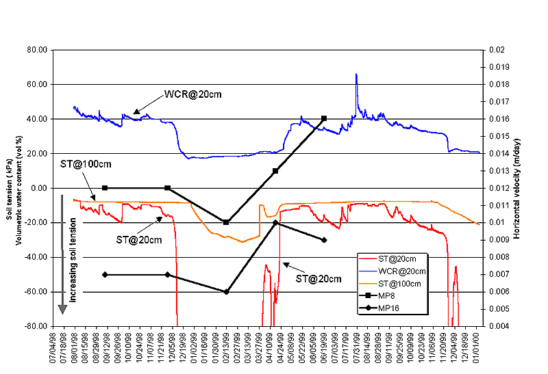
Figure 9. Volumetric soil-water content and soil tension at IS1 in relation to daily velocities of monitoring points MP8 and MP16 (see figure 2 for locations). Volumetric soil-water content (WCR) was measured at a depth of 0.2 m using a Campbell Scientific, Inc., Water Content Reflectometer (model CS615). The reflectometer uses time-domain measurement methods to determine the volumetric water content using an empirically derived calibration equation supplied by the manufacturer. Although Campbell Scientific suggests that the calibration equation is accurate within a few percent for a wide range of soil types and textures, a calibration curve has not yet been determined for the Slumgullion slide material. Therefore, the absolute values of volumetric water contents reported here should be considered estimates. Estimates of soil tension (ST) were obtained at depths of 0.2 and 1.0 m using Watermark model 200 soil moisture sensors manufactured by Irrometer Company, Inc. These sensors are electronic resistance devices whose output has been empirically calibrated to soil tension, also known as soil suction (see Eldredge and others, 1993). Saturated to near-saturated soil moisture conditions produce less negative soil tension values, whereas dryer soil moisture conditions result in more negative soil tension values. Guidelines from Irrometer suggest that saturated soils produce soil tension values ranging from 0 to –10 kPa, whereas dry soils are typically in the range of –100 to –200 kPa. Velocities of MP8 are representative of points MP1 – MP15 on the upper and middle parts of the slide (see fig. 6). Velocities of MP16 are representative of points MP16 – MP19 on the lower part of the slide. Velocities are plotted at the mid-points between GPS observations.
| AccessibilityFOIAPrivacyPolicies and Notices | |
| |
|