Mapping Southern Puget Sound Delta Fronts After the 2001 Nisqually
Earthquake
By James V. Gardner-1, Edward J. van den Ameele-2, Guy Gelfenbaum-1,
Walter Barnhardt-1, Homa Lee-1, and Steve Palmer-3
1-U.S. Geological Survey, Menlo Park, CA
2-National Oceanic and Atmospheric Administration, Seattle, WA
3-Washington State Dept. of Natural Resources, Olympia, WA
Introduction
Systems
Legacy Data
New Data
Nisqually Delta
Puyallup Delta
Duwamish Delta
Acknowledgements
Authors
References
INTRODUCTION
A moment magnitude 6.8 earthquake struck southern Puget Sound
(Figure 1 53k) on February 28,
2001 causing an estimated $0.7 to $1.4 billion in damages to buildings
and roadways in the region (Williams et al., 2001). The earthquake
source was 52-km deep with the epicenter located close to the
Nisqually River delta in the same location as the magnitude 7.1
earthquake of 1949 (http://www.geophys.washington.edu/SEIS/PNSN/).
These deep earthquakes occurred in the eastward-dipping subducting
slab of the Juan de Fuca plate and typically caused less damage
than shallower, crustal events of the same magnitude.
Geologists inspected the region immediately after the 2001 Nisqually
earthquake and reported numerous ground failures, including landslides
along coastal bluffs, lateral spreads, and liquefaction of alluvial
sediment in low-lying valleys.
Silt-laden water, or "mud plumes", were also observed
in the vicinity of major river deltas in southern and central
Puget Sound (Brian Sherrod, USGS, personal communication, 2001),
suggesting that submarine landslides may have occurred on the
seaward-sloping delta fronts. If submarine failures or even weakening
of the delta fronts were generated by this earthquake, they could
pose a hazard to the Ports of Seattle and Tacoma, which have been
constructed on artificially filled intertidal areas at the seaward
margin of the deltas. Failures could also threaten the integrity
of hazardous waste sites, including several on the U.S. EPA's
Superfund list that are located in or near the port facilities.
A joint National Oceanic and Atmospheric Agency (NOAA) U.S.
Geological Survey (USGS) cruise was rapidly organized to examine
the submerged parts of the Duwamish River delta (Seattle), Puyallup
River delta (Tacoma), and Nisqually River delta (a wildlife refuge
east of Olympia). During the period from March 19 to 30, 2001,
the NOAA Ship RAINIER used high-resolution multibeam systems
to map the bathymetry of these areas. Although no submarine failures
were found on the Nisqually River delta, a variety of failures
were observed on the Puyallup and Duwamish River deltas that may
be related to the earthquake. Several known landslides, such as
the 1894 landslide on the Puyallup River delta and the 1986 Duwamish
Head failure were also observed in the data, as well as numerous
previously undescribed failures. However, we cannot unequivocally
determine whether the failures mapped in March 2001 were caused
by the 2001 Nisqually earthquake, although the craters, head scarp,
and several of the landslides described below are very sharp and
well defined, rather than subdued, in appearance, suggesting recent
formation. The abundance of landslides, both known and newly revealed
by our survey, indicate that the sediment deposits of the delta
fronts and adjacent slopes in southern Puget Sound have a high
potential for failure. Certainly, with the new high-quality bathymetric
data in hand, we are much better poised to assess both potential
failure sites and document any future failures in these three
delta fronts triggered by the next major earthquake to strike
this region.
TOP OF PAGE
SYSTEMS
The RAINIER carries four 10-m multibeam-echosounder (MBES)-equipped
survey launches as well as two launches equipped with single-beam
echo sounders. In addition, the RAINIER has a hull-mounted
MBES system. Two of the MBES launches have Reson 8101 MBESs and
two have SeaBeam 1180 MBESs. The RAINIER has a SeaBeam
1050D MBES. Interested readers are directed to Hughes Clarke,
et al. (1996) for a description of the MBES technology. The Reson
8101 MBES uses a 240-kHz transducer array that generates 101 1.5°-wide
receive apertures that cover a nominal 150° maximum swath.
Both the SeaBeam 1050D and 1180 MBESs generate up to 126 1.2°-wide
receive apertures that cover maximum swaths of 150°. The SeaBeam
1180 operates at 180 kHz and the SeaBeam 1050D operates at 50
or 180 kHz. This survey only used the 180-kHz option because of
the shallow water depths. The ship and the MBES launches have
4-axis motion (pitch, roll, yaw, and heave) sensors and were navigated
with differential GPS-aided inertial navigation. All the data
were processed aboard the RAINIER in near real time.
LEGACY DATA
The best available pre-earthquake bathymetry for all three deltas
comes from a NOAA compilation of hydrographic-quality single-beam
echo-sounder data.
These data have a spatial resolution of 1 arc second (about 30
m) and were collected from 1994 to 1999 (Nisqually River delta),
1972 to 1982 (Puyallup River delta), and 1978 to 1992 (Duwamish
River delta). All data are spatially referenced to the WGS84 ellipsoid
and vertically referenced to mean lower low water. A 30-m digital
terrain model (DTM) for each of the three deltas and adjacent
basins was generated from these data for comparison with the new
data. These DTMs can be viewed at http://walrus.wr.usgs.gov/pacmaps/ps-index.html.
NEW DATA
The four MBES launches mapped about 12 km2/day and together required
only about 14 hr to map each of the deltas. During the evenings
aboard the RAINIER, the multibeam data from each launch
were edited for spurious soundings and tide corrected to mean
lower low water. The data from each launch were combined and gridded
at 1-m spatial resolution for water depths of 1 to 50 m, 2-m resolution
for depths between 50 and 100 m, and 4-m resolution at water depths
greater than 100 m to create DTMs. The land area is represented
by USGS 1-m-resolution digital orthophotos draped over USGS 10-m
DEMs. The legacy DTMs and the corresponding new DTMs were compared
for changes and the new data were inspected for features that
might be related to earthquake-induced failures.
NISQUALLY RIVER DELTA
Although the Nisqually River delta is within a few kilometers
of the earthquake epicenter, no failures are found in images at
1-m spatial resolution along the delta front. A color shaded-relief
map and several perspective views of the data can be viewed at http://walrus.wr.usgs.gov/pacmaps/ps-index.html.
The delta front is relatively steep (12°), narrow (100 m wide),
and nearly featureless. A zone of landslides with subdued, rather
than sharp, bathymetric definition occurs on the northeastern
inner margin of the channel but the subdued appearance suggests
these may be older failures and may not be related to the 2001
earthquake.
TOP OF PAGE
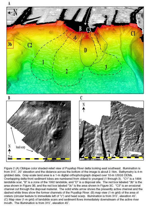
PUYALLUP RIVER DELTA
The Puyallup River delta is about 20 km northeast of the epicenter
of the Nisqually earthquake. The delta forms the gently sloping
(3.5°) southeast border of Commencement Bay; whereas the northeast
and southwest borders are steep-sided (17.5° to 19.5°)
walls of a Pleistocene glacial valley (Booth, 1978) and the northwest
side is open to the main channel of Puget Sound. The length of
the Puyallup River is unobstructed from its source on Mt. Rainier
to the delta, and the delta front has advanced at an average rate
of 2.5 km/ky for the past several thousand years (Dragovich, et
al., 1994). Several relatively large historic landslides have
modified the delta front. A sudden failure of the southwestern
corner of the delta front in 1894 (labeled "C1" on Figure 2 88kb) carried away a railroad
track and roadway and resulted in two deaths. The present failure
scar represents a volume of 2.615 km3 of material. Another sudden
failure occurred in 1992 midway along the delta front (labeled
"B" on Figure 2 88kb),
although neither of these events are correlated to an earthquake.
Both failures are located at the mouths of river channels and
the three largest submarine channels on the delta front also occur
immediately down stream of river mouths. This relationship suggest
sediment loading may have initiated the historic failures as well
as the formation, and possibly continued modification, of the
submarine channels.
Numerous small slumps and failures are found in the new bathymetric
data along the shallow edge of the delta front, especially in
the southern half. A linear string of craters as much as 25 m
in diameter and 0.5-m deep (labeled "c" on Figure
2B 88kb), as well as a head scarp of a large incipient failure
(Figure 2B 88kb), are found in
the northern portion of the delta front (area labeled "3b"
on Figure 2A 88kb). The craters
resemble expulsion features, similar in appearance to large pockmarks
(Hovland and Judd, 1988; Kelley et al., 1994). Whether the craters
and head scarp were caused by the Nisqually earthquake is problematic
because the resolution of the legacy data is too low to resolve
such small features for comparison. However, these are precisely
the type of features expected to be generated by severe ground
shaking (Field et al., 1992).
A marine disposal mound (labeled "D" on Figure
2 88kb) is located on the delta front where dumping continued
until the mid 1980s. The 1972 to 1982 bathymetric data for the
Puyallup River delta clearly show the disposal site as an intact
mound that rises about 18 m above the delta-front sediments. The
new data show that sometime after 1982 a major breach of the disposal
material has occurred and now a 100-m-wide, 15-m deep channel
(labeled C3 in Figure 2 88kb),
dissects directly downslope through the disposal material. The
erosional channel is directly down stream of the mouth of the
active Puyallup River channel. In addition, several relatively
large channels (as much as 2-m deep, 20-m wide, and 350-m long)
and landslides (on the lower west and upper east sides) have eroded
into the disposal material.
The surface of the delta front, including the floor of the eroded
channel in the disposal site, is mantled with bedforms. (Figure
2 88kb). The bedforms (wavelengths of 20 to 40 m and wave
heights of 1.5 to 2.0 m) would be called large subaqueous dunes
using the classification of Ashley (1990), formed by a process
presumably driven by hyperpycnal flows out of the Puyallup River.
However, the bedforms could also be interpreted as creep folds,
a slow but persistent gravity-induced downslope transport of sediment.
Regardless of the process operating, the new bathymetric data
suggest the middle third of the delta front is prograding northwestward.
The bathymetric data suggest that three overlapping lobes of sediment
occur on the delta front (labeled 1, 2, and 3 on Figure
2 88kb). Lobe 1 is the oldest and is overlapped by lobe 2,
which is overlain by the disposal material. Lobe 3, the youngest,
was formed in part by channel erosion through the disposal material.
DUWAMISH RIVER DELTA
The Duwamish River delta is about 40 km northeast of the Nisqually
earthquake epicenter. The delta front forms the sloping (6°
to 10°) southeastern border of Elliott Bay. The southwestern
and northeastern sides of the bay are relatively steep (10°
to 18°). Although in the past the Duwamish River delta has
prograded at rates as fast as 9 km/ky (Dragovich et al., 1994),
the river has been dammed for the past century so that the delta
is now relatively sediment starved. Numerous sediment slides and
craters were found on the Duwamish River delta front (Figure
3 76kb) but whether they were caused by the Nisqually earthquake
is again equivocal because of the poor resolution and the age
of the legacy data. Landslides occur at several places along the
delta front and along the sides of Elliott Bay. The landslides
vary in size and all appear to have originated close to the break
in slope that typically occurs between the 5 and 10-m isobath.
A single large crater on the northeastern side of the bay is located
650 m to the west-northwest of the head of an older landslide
scar (Figure 3B 76kb). The crater
has a 6-m wide flat floor, is 27 m in diameter at the top, and
is 1.6-m deep. Both the crater and the head of the landslide scar
occur at a depth of 52 m, suggesting a possible relationship of
the features with some unrecognized, buried, possibly weak, geological
strata that may be close to the surface at the 52-m isobath.
A series of relatively large landslides occur on the Duwamish
River delta front (see Figure 3C, 76kb for example). The landslides range in width from less than
40 m to more than 300 m and from less than 100 m to more than
500 m long. The heads of all of these landslides are in less than
15 m of water, within a few 10s of meters from the Port of Seattle
facilities. All of these landslides have a clearly defined head
scar, a channel, and a depositional lobe at their terminus.
A series of five channels incise the slope from north to south
on the eastern tip flank of Duwamish Head. The southern-most two
channels of this group appear to have been formed by landslides
with coalesced debris aprons at the base of slope. Other landslides
with a wide range of sizes are also found along the northeastern
flank of Elliott Bay in a range of water depths.
A landslide scar occurs about 7 km offshore immediately north
of Duwamish Head. This is the largest landslide in Elliott Bay,
with dimensions of 600+-m-long, 350-m wide, and this event removed
a 5- to 10-m-thick section of the slope from the 20-m to beyond
the 85-m isobath.
Another major sediment failure is located on the western flank
of Duwamish Head, in water depths of 15 to 70 m. The failure occurred
in 1986 during construction of a sewage outfall system and was
thought to involve about 400,000 m3 of material (Kraft, et al.,
1992). Volume calculations using the new data indicate 349,600
m3 of material was removed from the slope, suggesting little or
no failure has occurred since the initial event.
TOP OF PAGE
ACKNOWLEDGEMENTS
Captain Samuel P. DeBow, NOAA, Chief, Hydrographic Surveys Division,
Office of Coast Survey arranged for the NOAA ship RAINIER,
which is based in Seattle, to rapidly respond following the earthquake.
Commander Dan Herlihy, NOAA, Commanding Officier, NOAA Ship RAINIER, and the ship's crew accommodated the rapidly assembled cruise
with terrific spirit. The hydrographers and support staff aboard RAINIER edited and processed the data through the nights
and generated the high-quality data. We are indebted to all of
these dedicated individuals for producing such valuable data.
Thanks to Mike Field, Steve Eittreim, Brian McAdoo, and John Goff
whose reviews appreciably improved the manuscript.
AUTHORS
James V. Gardner, U.S. Geological Survey, Menlo Park,
CA, USA, Lieutenant Edward J. van den Ameele, NOAA, National
Oceanic and Atmospheric Administration, Seattle, WA, USA, Guy
Gelfenbaum, U.S. Geological Survey, Menlo Park, CA, USA, Walter
Barnhardt, U.S. Geological Survey, Menlo Park, CA, USA, Homa Lee,
U.S. Geological Survey, Menlo Park, CA, USA, and Steve Palmer,
Washington State Dept. of Natural Resources, Olympia, WA USA.
REFERENCES
Ashley, G.M., 1990, Classification of large-scale subaqueous bedforms:
A new look at an old problem. Jour. Sed. Petrology, v. 60, p.
160-172.
Booth, D.B., 1978, Timing and processes of deglaciation along
the southern margin of the Cordilleran ice sheet, in Ruddiman,
W.F. and Wright, H.E. Jr., eds. The Geology of North America,
vol. K-3, p. 71-90.
Dragovich, J.D., Pringle, P.T., and Walsh, T.W., 1994, Extent
and geometry of the Holocene Osceola mudflow in the Puget Lowland
implications for Holocene sedimentation and paleography.
Washington Geology, v. 22, p. 3-26.
Hovland, M. and Judd, A.G., 1988, Seabed Pockmarks and Seepages.
Graham and Trotman, London, 293 pp.
Field, M.E., Gardner, J. V., Jennings, A. E., and Edwards, B.
D., l982. Earthquake-induced sediment flows on a l/4o slope, Klamath
River Delta, California. Geology, v. l0, p. 542-546.
Hughes Clarke, J.E., Mayer, L.A., and Wells, D.E., 1996, Shallow-water
imaging multibeam sonars: A new tool for investigating seafloor
processes in the coastal zone and on the continental shelf. Mar.
Geophys. Researches, 18:607-629.
Kraft, L.M. Jr., Gavin, T.M., and Bruton, J.C., 1992, Submarine
flow slide in Puget Sound. Jour. Geotechnical Engineering, v.
118, p. 1577-1591.
Kelley, J.T.,Dickson, S.M., Belknap, D.F., Barnhardt, W.A., and
Henderson, M. 1994, Giant sea-bed pockmarks: Evidence for gas
escape from Belfast Bay, Maine. Geology, v. 22, p. 59-62.
Williams, C.R., Windeler, D.S., Rahnama, M., Morrow, G.C., and
Rodriguez, A., 2001, Insured loss estimates for the 28 February
2001 Nisqually earthquake. Seismological Soc. Amer. Ann. Mtg.,
San Francisco, CA. |

