Cruise Report
NOAA Ship Rainier, cruise R1-01: Multibeam mapping the
major deltas of southern Puget Sound
Seattle, WA to Seattle, WA, March 19, 2001 to March 30, 2001
James V. Gardner, U.S. Geological Survey
Purpose and Cruise Plan
Multibeam Systems
Data Processing
Cruise Log
USGS Processing Streams
Personnel
Media Visit to Ship
PURPOSE AND CRUISE PLAN
Cruise R1-01 of the NOAA Ship Rainier (Figure 1, 55kb) was a joint cruise
of the National Oceanic and Atmospheric Administration (NOAA)
and the U.S. Geological Survey (USGS) to investigate how the three
major deltas in southern Puget Sound faired during the magnitude
6.8 Nisqually earthquake of February 28, 2001. The cruise was
organized because of concerns that submarine landslides on the
delta fronts may have been initiated by the earthquake. The Duwamish
and Puyullap River deltas (Figure
2, 30kb) have extensive infrastructures that include major
port facilities (Ports of Seattle and Tacoma, respectively) built
out to their delta fronts. There is no high-resolution multibeam
bathymetry of the Puyallup delta front but NOAA conducted two
small high-resolution multibeam surveys in 1999 in the vicinity
of the Duwamish delta. The best available digital data for the
Puyullap delta come from a 30-m spatial resolution compilation
of single-beam data collected from 1972 to 1982. The existing
digital bathymetry for Nisqually and Duwamish deltas is a 30-m
spatial resolution data set, also from single-beam data, from
1972 to 1999. Although the Nisqually delta presently is a wildlife
refuge with no infrastructure, it is the largest delta in southern
Puget Sound.
The cruise plan called for the Rainier to transit from
Lake Union to Commencement Bay (Tacoma) and deploy its four multibeam-equipped
launches to map the Puyallup delta. The ship and the multibeam
launches were patch tested in Lake Union the previous week and
required no further calibrations. The Rainier will anchor
in Commencement Bay until that survey is completed. Then the Rainier will recover the launches and transit through Dulco Passage, around
Pt. Defiance and down the Tacoma Narrows. Multibeam data will
be collected by the Rainier during this transit. Once in
the area of Nisqually Reach, the Rainier will anchor and
deploy the 4 multibeam survey launches to map the Nisqually delta.
Once the Nisqually delta mapping is completed, the launches will
be recovered and the ship will transit to Port Townsend bay and
map that area. The Port Townsend area was scheduled for mapping
at this time prior to the USGS request and is not part of the
post-earthquake survey. Consequently, this report will not include
maps of the Port Townsend area. Six days were allocated for mapping
Port Townsend, then the plan called for a transit back to Elliot
Bay to commence mapping the Duwamish delta with survey launches.
TOP OF PAGE
MULTIBEAM SYSTEMS
The NOAA Ship Rainier carries 6 30-ft survey launches;
4 with multibeams and 2 with singlebeam systems (Figure 3, 20kb). The Rainier has an Elac SeaBeam 1050D multibeam (MBES) system, two of the
survey launches have Elac SeaBeam 1180 MBESs (boats RA3 and RA4)
and two survey launches have Reson 8101 MBESs (boats RA1 and RA6).
The vehicle motion sensors on Rainier and each launch are
Applied Analytics TSS Pos/MV model 320 version 3. The ship and
launches all have SeaBird CTDs for determining water sound speeds.
The Elac Seabeam 1180 operates at 150 kHz whereas the Reson 8101
operates at 240 kHz. The ship's Elac SeaBeam 1050D is a dualfrequency
MBES that operates at 50 or 180 kHz. This survey will use only
the 180-kHz option because of the shallow water depths. Both the
Elac SeaBeam 1050D and 1180 MBESs (Figure 4, 18kb) generate
126-1.2° receive apertures that cover a maximum of 150°
swath, whereas the Reson 8101 (Figure
5, 16kb) generates 100-1.5° receive apertures that cover
a maximum of 150° swath. Both systems use amplitude and phase
detection for depth determinations. Navigation for the Rainier was by Trimble DGPS but the launches used a combination of inertial
navigation from the POS/MVmotion sensor and Trimble DGPS. Initially,
tidal corrections were made from predicted tides, but measured
6-minute tides were downloaded from PMEL and applied 24 hr after
the data collection. The vertical reference datum for all depth
measurements is mean low low water (MLLW). The horizontal reference
datum used for all NOAA-generated data is the NAD83 ellipsoid
which, for the scale of the present mapping, is identical to WGS84.
DATA PROCESSING
NOAA hydrographers aboard each survey launch performed initial
processing of the data. This included refraction corrections from
measured sound-velocity profiles and monitoring proper motion
compensation as well as swath overlap. However, all lines are
preplanned prior to launch deployment and a rarely do the launches
change the location of the preplanned line. This procedure caused
some data holidays between outer beams of adjacent lines. The
NOAA hydrography staff aboard Rainier performed navigation
and beam editing, applied predicted-tide corrections, and generated
point-data output files in ASCII UTM. The NOAA hydrographers routinely
edit the outer 10 beams (±15°) of each swath generating
a 120° swath of usable data. Each days processed files from
each launch were exported to ascii xyz, compressed, and ftped
over the network to the USGS SGI workstation for gridding, visualization,
and preliminary analysis. In addition, each edited line file was
exported to the USGS SGI workstation in GSF format from the NOAA
NT/Caris processing system. Apparently, only the NT version of
Caris has the "save as GSF" option. The exported GSF
data retain all the editing flags so that cleaned data (navigation
and beam edited, as well as tide and refraction corrections) could
be directly opened on the USGS SGI workstation in UNB/OMG SwathEd
software, the beam-editing software used by the USGS Pacific Seafloor
Mapping Project. See USGS Processing Streams section (below) for
more details.
All NOAA georeferenced data were exported in UTM zone 10 and
transformed to geographic coordinates (latitude and longitude)
referenced to the WGS84 ellipsoid prior to gridding. All point
data were initially gridded at 2- or 3-m spatial resolution, depending
on water depths so as to gain a high-resolution view of the shallow-water
are.
TOP OF PAGE
CRUISE LOG
March 19, 2001 (JD 078) (local time is GMT + 8 hours)
The NOAA Ship Rainier departed the NOAA Marine Center,
Lake Union, Seattle, WA at 0800 hr (PST) with 4 multibeam and
2 singlebeam survey launches. The ship's compass was calibrated
in Lake Union prior to transiting from Lake Union through the
Chittenden Locks and entering Puget Sound. The morning was spent
setting up computers in the Plot Lab. The USGS SGI monitor was
damaged in shipping to Seattle and the screen would not display.
A spare monitor was borrowed from the ship and worked, indicating
either a bad monitor or bad monitor cable. The ship's spare monitor
was used throughout the survey.
The Rainier arrived in Commencement Bay at 1330 hr under
cool and drizzly weather, anchored, and deployed the 4 multibeam
survey launches. The launches were in the water and collecting
data by 1400 hr and returned at 1800 hr. The launches collect
data at 8 kts maximum speed. Most of the deep-water area of Commencement
Bay was completed by the end of the day. The day's data were downloaded
from the launches to the ship's server and data processing commenced
during the night.
March 20, 2001 (JD 079) (local time is GMT + 8 hours)
Today was declared Media Day so from 0930 until 1600 hrs the ship
and two launches ran tours for the TV and print media. The weather
was sunny and breezy. Even with the distractions of the media,
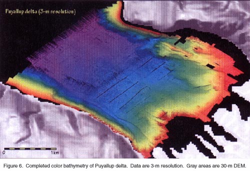
Commencement Bay was essentially completed by the end of the day
(Figure
6, 40kb, Figure
7, 60kb, and Figure
8, 65kb). A few small gaps in the data will be filled in tomorrow,
although we decided that holidays in the deeper areas were not
worth the time expenditure to fill in. Consequently, the Rainier stayed at anchor in Commencement Bay.
March 21, 2001 (JD 080) (local time is GMT + 8 hours)
The four multibeam launches traversed from Commencement Bay to
Nisqually Reach, mapping during the transit two small areas on
either side of Point Defiance where muddy plumes were observed
in the water immediately after the earthquake. The were in the
water by 0700 hr and began to fill in the few shallow-water holidays
in the Commencement Bay data. The weather was sunny and calm.
While the survey boats finished mapping Commencement Bay, the Rainier departed at 1000 hr to transit through the Tacoma
Narrows to Nisqually Reach. The Rainier collected multibeam
data on its transit and surveyed the eastern deep-water portion
of Nisqually Reach. The four launches completed the two small
areas on either side of Defiance Point (Figure 9, 46kb)
and transited to Nisqually Reach where they mapped for the remainder
of the day.Rainier completed a survey of the deep-water
portion of eastern Nisqually Reach about 1400 hr and anchored
off Tatsolo Point. The survey launches returned to Rainier about 1700 hr and had completed mapping about half of Nisqually
Reach by the end of the day.
TOP OF PAGE
March 22, 2001 (JD 081) (local time is GMT + 8 hours)
The four MBES launches were in the water by 0800 hr, collecting
data under bright, cool, and calm conditions. The survey launches
spent the day finishing mapping Nisqually Reach. All data from
JD078, JD079, and JD080 had to be reprocessed because the data
had been processed with the wrong predicted tides as well as with
an incorrect roll-bias corrector. All the original processed data
were deleted and replaced with the corrected data. The Nisqually
Reach mapping was completed by 1200 hr and the survey launches
were retrieved for departure for Port Townsend. We departed at
1230 hr but the ship was asked by a local sheriff's department
to spend a few hours searching for the bodies of two drowning
victims a few day ago in the head of Henderson Bay off the town
of Purdy. Rainier steamed to the head of Henderson Bay
and deployed two multibeam survey launches. The launches searched
until 1700 hr, to no avail. The launches were recovered by 1730
hr and Rainier departed for Port Townsend.
The Nisqually delta front shows little evidence of recent failures
(Figure
10, 31kb and Figure
11, 60kb). However, several old, subdued landslide scars were
found. The most striking aspect to the bathymetry of Nisqually
Reach is that the bedforms west of a north-south center line all
are asymmetrical with the stoss sides facing west whereas the
stoss sides of the bedforms east of the center line all face east.
March 23, 2001 (JD 082) (local time is GMT + 8 hours)
The Rainier arrived at anchor off Port Townsend during
the night. The four multibeam launches were deployed at 0800 hr
and commenced mapping the area immediately south of Port Townsend.
The weather was cool, mostly sunny and calm. The entire day was
spent reprocessing data from JD078, JD079, and JD080.
Ron Schaff looked at the Reson 8101 sidescan formatted in xtf
and said that the raw data are in voltages (0 to 5 vdc) and that
the Caris software is logarithmically expanding the voltages to
an 8-bit range. However, when I capture the xtf data stream, I'm
actually capturing voltages, thus the poor quality records. This
explanation sounded dubious to me. However, John Hughes Clarke
was queried about this problem and he suggested using xtf2glo
max16bitval 4096 to see if that helped. This flag should
expand the 8 bit or 16 bit range to 0 to 2n (whatever maximum
value desired) from the maximum 8-bit (255) or 16-bit (65535)
value.
March 24, 2001 (JD 083) (local time is GMT + 8 hours)
The day was spent at anchor off Port Townsend. The weather was
partly cloudy, cool, and calm. Four multibeam launches were deployed
at 0800 hr. The day was mapping Port Townsend while those aboard Rainier spent the day capturing and reformatting the edited
GSF multibeam files to OMG format (see Processing Streams section
below). I discovered a screen message in the xtf2glo output that
suggested the Reson 8101 sidescan data were being recorded in
8-bit dynamic range. One survey launch was asked to record the
sidescan data in 16-bit range but those data proved to be no better.
TOP OF PAGE
March 25, 2001 (JD 084) (local time is GMT + 8 hours)
The day was spent at anchor off Port Townsend. The weather was
partly cloudy and cool with 20-kt winds gusting to 30 kts.. The
four multibeams were deployed at 0800 hr but two of them had a
variety of problems with their POS/MV IMU and with bottom tracking.
A choppy sea state might have contributed to the problems. The
day was spent mapping off Port Townsend, although some time was
spent picking up stranded windsurfers and various boaters in distress.
Scripts were developed to convert GSF-formatted MBES datagrams
to OMG.merged format. The launches started returning to the ship
about 1630 hr and by 1700 hr all were aboard.
March 26, 2001 (JD 085) (local time is GMT + 8 hours)
The day was spent at anchor off Port Townsend. The weather was
cloudy and cool, but cleared in the afternoon, with gentle breezes.
The four multibeams were deployed at 0800 hr and continued mapping
Port Townsend area. The launches returned to the ship at 1700
hr.
March 27, 2001 (JD 086) (local time is GMT + 8 hours)
Continued mapping Port Townsend area. The weather was cloudy,
cold, with the wind at 30 kts out of the north. Two of the launches
had mechanical problems in the morning and one of them had to
be towed back to the ship for repairs. The weather worsened throughout
the morning and into the afternoon. Operations were cancelled
after lunch because of weather. The launches were recovered without
incident.
March 28, 2001 (JD 087) (local time is GMT + 8 hours)
The day was spent mapping Port Townsend area. The weather was
cloudy, cool, with breezes. Only three launches were deployed
because the fourth was still being repaired. The launches were
deployed at 0800 hr and were recalled at 1530 hr for preparations
to depart Port Townsend for the Elliot Bay area. We arrived across
the sound from Seattle and anchored in Yukon Bay for the night.
March 29, 2001 (JD 088) (local time is GMT + 8 hours)
Three MBES launches were deployed at 0700 hr and headed across
the sound for Elliot Bay while the ship moved from anchor to the
fuel dock at Orchard Point. The day was increasingly cloudy, cool,
and breezy. After fueling, the Rainier crossed the sound
and tied up at a downtown pier. The three launches returned to
the ship at 1500 hr because of increasing winds and chop, although,
they had completed mapping most of Elliot Bay.
TOP OF PAGE
March 30, 2001 (JD 089) (local time is GMT + 8 hours)
Three MBES launches were deployed at 0800 hr and mapped holidays
in yesterdays data and completed a small survey of the west side
of Duwamish Head. The day was partly cloudy, cool, and breezy.
Most of the day was spent editing JD088 data. The launches returned
to the ship by 1200 hr. The unedited data suggests the delta has
little evidence of recent landsliding (Figure 12, 30kb and Figure
13, 32kb), although older landslides are apparent. However,
the slope west of Duwamish Head has a very fresh-looking failure
(Figure
14, 25kb). The failure is 300-m wide at its widest, about
160-m long, and has excavated as much as 14-m deep into the sediments.
Two sewer pipes are shown on the nautical charts that terminate
at the shallowest end of the failure.
A curious circular depression with raised rim occurs off the
Seattle waterfront in 50-m depths (Figure
15, 28kb). The bottom of the depression is relatively flat
and 10-m across, whereas the rim is about 20-m across. The depression
is 1-m deep and resembles an expulsion feature.
March 31, 2001 (JD 090) (local time is GMT + 8 hours)
The morning was spent backing up files, packing, and preparing
computer equipment for shipment back to Menlo Park. I departed
the ship at 1300 hr.
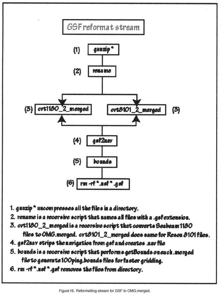
PROCESSING STREAMS
Two special processing streams had to be created at sea to read
the NOAA data. Figures
16 (89kb) and Figure
17 (101kb) show the processing stream for converting individual
multibeam bathymetry lines from GSF to UNB/OMG.merged formats
and for converting Reson 8101 sidescan lines from XTF to UNB/OMG.glo
(.ss) format. These conversions were necessary so that the USGS
Pacific Seafloor Mapping software (UNB/OMG SwathEd suite) could
read the raw and edited NOAA data. However, it must be noted that
the Reson 8101 sidescan data are recorded as a conventional sidescan
timeseries from a separate receiver array; consequently, the data
are not coregistered with the simultaneously collected bathymetry
and the sidescan amplitudes are uncalibrated. One of the issues
uncovered during the cruise is the very compressed dynamic range
of the Reson 8101 sidescan data. Although the ISIS recording system
has options for capturing the data in either 8 or 16 bit, neither
setting produced acceptable data once translated from XTF to UNB/OMG
format. The volume of Reson 8101 sidescan data was so large that
the data were only recorded and archived and will be processed
in the USGS Pacific Seafloor Mapping Lab after the cruise.
TOP OF PAGE
PERSONNEL
Cmdr Daniel Herlihy, Captain of NOAA Ship Rainier
Lt. E.J. van den Ameele, NOAA Field Operations Officer
Dr. James V. Gardner, USGS scientist in charge
MEDIA VISIT TO SHIP
Gilbert Arias, Seattle Press-Intelligencer
Mike Borher, Seattle Press-Intelligencer
John Dodge, The Olympian
Tony Overman, The Olympian
John Larsaard, KOMO-TV
Keith Eldridge, KOMO-TV
Jay Johnson, KIRO-TV
Sandi Doughton, The News Tribune, Tacoma
Peggy Anderson, Associated Press
Lauren McFalls, Associated Press
Glenn Farley, KING-TV
Ken Jones, KING-TV
John Yeager, KCRQ-TV
Bill Bushmaker, KCPQ-TV
Ross Anderson, Seattle Times |

