Surficial Geology and Distribution of Post-Impoundment Sediment in Las Vegas Bay, Lake Mead
Introduction
Click on each figure for larger image with caption.
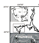
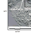
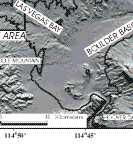
Figure 1. Maps showing location of Lake Mead in the southwestern United States, Boulder Basin at the western end of the lake, and the study area in the northwestern corner of Las Vegas Bay.
Lake Mead is a large reservoir located in the Mojave Desert of southern Nevada and northwestern Arizona (Fig. 1). The lake was formed in 1935 after completion of the Hoover Dam, and now floods the valleys carved by the Colorado River, the Virgin River, and several ephemeral streams. The Colorado River supplies approximately 98% of the annual inflow to Lake Mead (Preissler and others, 1998; Water Resources Data, Arizona Water Year 1998, 1998). The remainder is derived from the Virgin and Moapa Rivers in the Overton Arm, the Las Vegas Wash in Las Vegas Bay, and a number of ephemeral washes that surround the lake. The lake provides water for agricultural, residential, commercial, industrial, recreational, and other non-agricultural users in communities across several states in the southwestern U.S.
The effects of these rivers and ephemeral streams on the ecosystem of Lake Mead have been extensively studied (Preissler and others, 1998; Bevans and others, 1996; Bevans and others, 1998; Covay and Leiker, 1998; LaBounty and Horn, 1997; Paulson, 1981). Much of this work has centered on Las Vegas Bay because much of the groundwater and storm runoff from the Las Vegas metropolitan area discharges into this part of the lake through Las Vegas Wash (LeBounty and Horn 1997). Many of these studies involved determining levels of anthropogenic contaminants such as synthetic organic compounds, heavy metals and dissolved ions, furans/dioxins, and nutrient loading in lake water, sediment and biota. Further concerns arise because Las Vegas Wash enters Lake Mead within 12 km of the water intake station at Saddle Mountain that provides water for municipal and industrial users of the greater Las Vegas Metropolitan area.
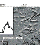
Lacking from the prior studies, however, is a detailed understanding of the geology of the lake floor and post-impoundment sedimentation. To address this question, Twichell and others (1999) mapped much of the Las Vegas Bay and Boulder Basin sections of Lake Mead using sidescan sonar and seismic-reflection techniques. A sidescan sonar mosaic of the lake bottom shows that post-impoundment sediment mostly occupies the floors of the former river and stream systems. The seismic-reflection data show that these deposits are thickest in the deep part of Boulder Basin, where parts of the former Colorado River bed are now covered by more than 40 m of sediment. In Las Vegas Bay, post-impoundment sediment covering the floor of the former Las Vegas Wash was traced continuously from the edge of the survey area near the Las Vegas Bay Marina southeastward to Boulder Basin (Twichell and others, 1999). The sediment distribution pattern in Las Vegas Bay and Boulder Basin suggests transport of sediment as turbid density flows as first proposed by Gould (1951).
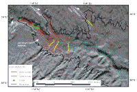
The shallow water area in the northwestern corner of Las Vegas Bay (Fig. 2) could not be surveyed during the 1999 field program due to limitations of the survey vessel. This area is of critical interest because Las Vegas Wash is a major source of sediment. The thickness and size of a delta suspected to be forming at the mouth of the Wash was unknown. To map the sediment in the shallow part of Las Vegas Bay and the delta at the mouth of Las Vegas Wash in 2000, the U.S. Geological Survey, in cooperation with the University. of Nevada, Las Vegas, conducted a second geophysical survey and collected several short cores (Fig. 2).
Although most of the survey effort during 2000 was immediately off Las Vegas, Gypsum, and Government Washes, the new data were integrated with data collected in 1999 (Twichell and others, 1999) to frame this localized area in the larger context of Las Vegas Bay. This report summarizes the interpretations based on the integration of sidescan sonar and seismic-reflection data collected during these two surveys in the northwestern part of Las Vegas Bay (Fig. 2).
|