
Digital Mapping Techniques '01 -- Workshop Proceedings
U.S. Geological Survey Open-File Report 01-223
Making Improved Geotechnical Maps with Spatial Analysis
By Steven L. Martin
Kentucky Geological Survey
University of Kentucky
228 Mining and Mineral Resources Building
Telephone: (859) 257-5500
Lexington, KY 40506
Fax: (859) 257-1147
e-mail: smartin@kgs.mm.uky.edu
Geologic maps of McCracken County in the Jackson Purchase Region of western Kentucky show a wide variety of unconsolidated to moderately consolidated materials. These materials consist of unconsolidated silt, clay, sand, and gravel of alluvial, lacustrine, and loessal origin; poorly consolidated sandy, clayey continental gravel; and poorly to moderately consolidated sand, lean to plastic clay, and mixtures of interlayered silt, sand, and clay deposited in lacustrine and near-shore deltaic environments. This region is known to be susceptible to a number of geotechnical problems in response to natural phenomena such as springs, erosional agents (flooding and landslides), and earthquakes. Previous studies have shown relationships between geologic map units and geotechnical behavior. These studies include field and laboratory investigations that predict behavior of lithologic units when disturbed by engineering and construction practices, as well as the behavior of lithologic units in response to natural phenomena. Traditional geotechnical maps have been reclassifications of geologic map units based on similar rock types and engineering properties. Improved geotechnical maps will be produced using one or more of the following geospatial techniques:
- comparing geologic map units to surface slope
- comparing geologic map units to subsurface horizons using geophysical and borehole analysis
- using remote sensing to detect properties of geologic map units
- analyzing geotechnical test results in the context of geologic map units.
To enhance the usability of our maps, a database of geotechnical information will be included. This database will contain information about geotechnical materials, their properties, how these materials might behave, and how they might affect man-made structures under certain conditions. It is our goal to build a database that relates geologic factors to engineering problems. For example, the most common unconsolidated to poorly consolidated material in the area is silt and clay. An important property of this material is moisture content. If the moisture content is high, its slope stability is poor, and this will affect structures such as roads and buildings (Finch, 1968; Nichols, 1968). Also exposed in the area is a moderately consolidated, plastic clay formation. This clay's mineral composition, specifically, calcium montmorillonite, is an important property. When exposed, the clay desiccates, producing a volume change, thus affecting slope stability (Finch, 1968; Nichols, 1968). In the future, we hope to develop a system in which the user can select a formation, and have a choice of information to choose from (lithologic, geotechnical, geohazard, economic, etc.) (Fig. 1). This information would not replace site investigations, but could assist in engineering or construction planning.
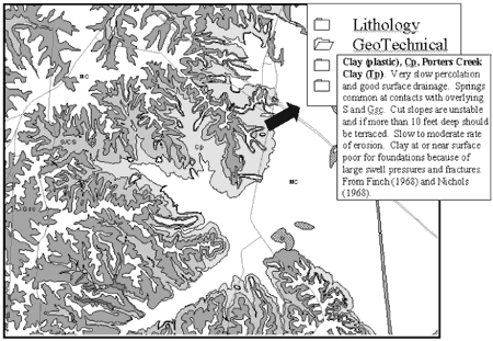
Figure 1. Geotechnical map of part of McCracken County showing information related to a geotechnical unit. MC=silt and clay (light gray). Cp=plastic clay (gray). S/CS=sand/clayey sand (medium gray). Gsc=gravel,sand, and clay (dark gray). G=gravel (gray stipple). Location of local roads and fractures also shown.
|
REFERENCES
Finch, W.I., 1968, Engineering geology of the Paducah West and Metropolis quadrangles in Kentucky: U.S. Geological Survey Bulletin 1258-B, 19 p.
Nichols, T.C., Jr., 1968, Engineering geology of the Paducah East quadrangle in Kentucky: U.S. Geological Survey Bulletin 1258-A, 13 p.
RETURN TO Contents
National Cooperative Geologic
Mapping Program | Geologic Division |
Open-File Reports
U.S. Department of the Interior, U.S. Geological Survey
URL: https://pubsdata.usgs.gov/pubs/of/2001/of01-223/martin.html
Maintained by David R. Soller
Last modified: 18:24:56 Wed 07 Dec 2016
Privacy statement | General disclaimer | Accessibility