|  | Appendix B: Core DescriptionsCore BH-00-06 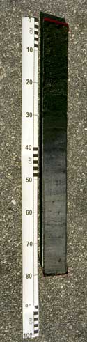
[larger image 148K] | | Location: | Port Neches, Orange County, TX
Latitude N30°00'50.79"
Longitude W93°54'46.69"
Water depth 0.53 m
Length recovered 0.77 m
Date obtained 06/16/2000
Date described 08/18/00
| | 0-12 cm | Organic Mud Brownish black (5YR2/1)
Root mat: 10% 1.5-2 cm, 20% 1-2 mm, 70% <1mm-fibrous
8-12cm - right side of core differs from above and has less than or equal to 0.5mm-fibrous roots and spongy texture (which grades into section below)
* gradational contact | | 12-41 cm | Mud Med. light gray (N6) and med. dark gray (N4)
Abundant mottling but decreasing with depth
51-52 cm mottling resembles laminations
Roots: <1 mm (random)
64-65 cm oxidized organic lens
grayish green (10GY 5/2) (v. small pelletlike)
70-77cm color changes gradually to a darker shade of olive gray (5Y4/1) Ð more uniform brown color, 1-2 mm roots (v. random) | | 41-77cm | Mud Pale olive (10Y6/2)
Roots: 5% less than or equal to 0.5mm, 95% fibrous (random)
* distinct contact | | « Port Neches Core BH-00-05 | Caplen Field Core COF-00-01 » |