Link to USGS home page
Coastal and Marine Geology Program
Coastal & Marine Geology Program >Subsidence and Fault Activation . . . >Open File Report 01-274

Return to: Sediment-Surface Profiles | Sediment Cores

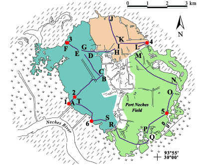
Fig. 2. Locations of shallow cores (numbers) and sediment-surface profiles (letters) surveyed at the Port Neches Field. Also shown in color are the three areas used to calculate accommodation space created by subsidence and erosion.

Click on a core number to see the core description; click on a profile line to view the profile; or click on the text links below.


Cores: BH-00-01 | BH-00-02 | BH-00-03 | BH-00-04 | BH-00-05 | BH-00-06

Profiles: A-B | C-D | E-F | G-H | I-J | K-L | M-N | O-P | Q-R | S-T

Locations of shallow cores (numbers) and sediment-surface profiles (letters) surveyed at the Port Neches Field. Also shown in color are the three areas used to calculate accommodation space created by subsidence and erosion.
Port Neches Core BH-00-06Port Neches Core BH-00-05Port Neches Core BH-00-04Port Neches Core BH-00-03Port Neches Core Bh-00-02Port Neches Core BH-00-01Port Neches bathymetric profile S-TPort Neches bathymetric profile S-TPort Neches bathymetric profile Q-RPort Neches bathymetric profile O-PPort Neches bathymetric profile O-PPort Neches bathymetric profile M-NPort Neches bathymetric profile K-LPort Neches bathymetric profile K-LPort Neches bathymetric profile I-JPort Neches bathymetric profile G-HPort Neches bathymetric profile E-FPort Neches bathymetric profile C-DPort Neches bathymetric profile A-BPort Neches bathymetric profile A-BPort Neches bathymetric profile A-B.Port Neches bathymetric profile A-B.

Return to: Sediment-Surface Profiles | Sediment Cores

Coastal & Marine Geology Program >Subsidence and Fault Activation . . . >Open File Report 01-274

[an error occurred while processing this directive]