|
Introduction
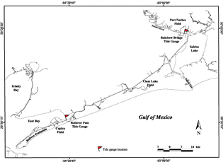
Wetland losses can occur around the shores of pre-existing water bodies or they can develop within the marsh interiors. Wetland losses along the margins of bays and lakes can result from both (1) erosion by waves and (2) inundation by a relative rise in sea level (submergence). Even in small water bodies where the fetch is limited, strong winds in the Gulf Coast region are capable of generating enough wave energy that shoreline erosion is common, and it often leads to enlargement of the water bodies. Enlargement of the water bodies can include both increased surface areas and increased water depths. The present study focuses on interior wetland losses because erosion around open-water perimeters is common even in areas where no subsidence has been documented. Submergence could be directly linked with induced subsidence but bank erosion would only be indirectly linked to subsidence through increased water depths and thus potentially greater wave energy. There are two competing hypotheses to explain some of the major interior wetland losses around oil and gas fields in the Gulf Coast region. One hypothesis states that the observed historical changes from interior wetlands to open water are primarily a result of land-surface subsidence. If that explanation is correct, then some of the roots and organic-rich marsh sediments may be preserved and remain in place stratigraphically under the former wetland area that subsided. The second hypothesis states that erosion of organic marsh sediments is primarily responsible for the changes from interior wetlands to open water. According to this hypothesis, the marsh plants are weakened and die either as a result of water logging or salt-water intrusion (Naidoo et al., 1992). When plant density decreases, the hydrodynamic forces in the marsh begin to erode and remove the organic-rich sediments from the marsh. Once the organic sediments are in suspension, they can be exported from the marsh into adjacent channels or other water bodies by currents driven by tidal and meteorological processes. Neither of these two hypotheses is mutually exclusive and both subsidence and erosion are likely contributors to the wetland changes that have been observed. Three large, mature oil and gas fields in coastal southeast Texas (Fig. 1) were selected to evaluate the competing hypotheses of wetland losses, and to characterize ground conditions near active faults and zones of subsidence. During June 2000, sediment cores were collected and topographic and bathymetric profiles were surveyed at the Caplen Field in Galveston County and the Port Neches Field in Jefferson County. Ground observations also were made and a topographic profile was surveyed at the Clam Lake Field in Jefferson County. The primary reasons for acquiring the field data were to determine how much original organic material remained at the submerged sampling sites and to determine the magnitude of subsidence and/or erosion that had occurred. Combined topographic and bathymetric profiles also were surveyed to characterize the subaerial and adjacent submerged surfaces, and to estimate the volume of accommodation space created by wetland losses at each location. Accommodation space represents the volume of open water that was created either by subsidence or erosion and replacement or removal of the surficial sediments. |