USGS Home - www.usgs.gov
Coastal and Marine Geology Program
Coastal & Marine Geology Program > Center for Coastal & Regional Marine Studies > OFR 01-382

Return to: OFR 01-382

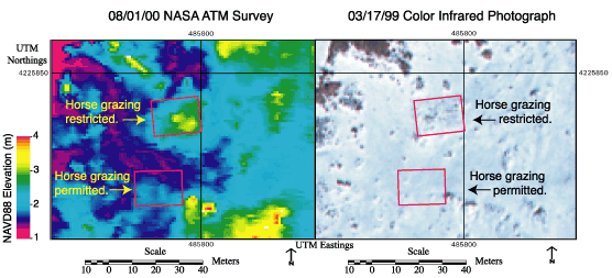
Figure 7. August 1, 2000, NASA ATM survey and March 17, 1999, color-infrared photograph of the northernmost pair of experimental plots. Topographic difference is about 1 to 2 m with significant vegetation cover difference between fenced and unfenced plots.
August 1, 2000, NASA ATM survey and March 17, 1999, color-infrared photograph of the northernmost pair of experimental plots. Topographic difference is about 1 to 2 m with significant vegetation cover difference between fenced and unfenced plots.

Return to: OFR 01-382


U.S. Department of the Interior, U.S. Geological Survey
URL: http://pubs.usgs.gov/of/2001/of01-382/fig7.html
Maintained by Publishing Services
Last modified: 13:50:25 Tue 21 May 2002
Privacy statement | General disclaimer | Accessibility