A preliminary finite-element analysis of a shallow landslide in the Alki area of Seattle, Washington.
| By
S. Debray
and W.Z. Savage Open-File Report 01-0357 2001 |
 |
This report is preliminary and has not been reviewed for conformity with U.S.Geological
Survey editorial standards nor with the North American Stratigraphic Code.Any
use of
trade names in this publication is for descriptive purposes only and does not
imply
endorsement by the U.S.Government.
U.S.Department of the Interior
U.S.Geological Survey
The Seattle area has a long history of landslide problems (Tubbs, 1974, Thorsen, 1989, Galster and Laprade, 1991, Baum, and others, 1998). Shallow landslides often initiate in colluvium derived from glacial deposits, are frequently triggered by winter rain storms (Tubbs, 1974), and may mobilize into debris flows that can cause considerable damage (Baum and others, 1998).
In this report we present a preliminary finite-element based stability analyses of a shallow landslide that occurred during the period from December 1996 to early January 1997 near Alki Beach and Duwamish Head at the north end of West Seattle (Figure 1). During this period a series of snowstorms, freezing rain and warm rain produced many debris flows and landslides in the Seattle area (Baum and others, 1998). The shallow landslide that we are analyzing was 18 m high and 75 m long. It mobilized into a debris flow that traveled down a 35-meter-high embankment below the slide damaging the bottom floors of two apartment buildings at the foot of the embankment (Figure 2). In what follows, we briefly outline the geology and hydrology of the Alki landslide site, give a short description of the computational algorithms used in the finite element program, and present the results of the finite element model of the landslide.
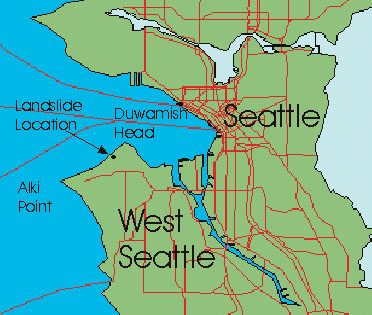
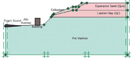
Figure 1. Alki landslide location.
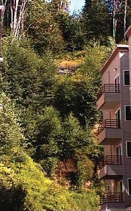
Figure 2. View
of the Alki landslide area. Photograph taken August 2001 by S. Debray.
Resistant and relatively impervious Vashon Till commonly caps Seattle-area hilltops (Tubbs, 1974, Galster and Laprade, 1991). This layer impedes water infiltration. However, at the Alki slide, till coverage is absent and, thus, surface water can percolate into the underlying Esperance Sand continuing downward until it reaches the relatively impervious Lawton Clay. Groundwater then moves laterally in the Esperance Sand reaching the colluvium and emerging as springs on the hillside. If the rate of infiltration exceeds the capacity of the hydraulic gradient to transmit groundwater to hillside seeps, pore pressures rise and slope failure ensues.
A detailed geotechnical investigation of the Alki glacial deposits is beyond the scope of this work. Therefore Alki-site property values are taken from a previously published summary (Savage and others, 2000b) and from data reported by Shannon and Wilson (2000). Peak cohesion (Cp) for the Alki colluvium is taken by Shannon and Wilson (2000) to be zero. We estimate it to be to be 5 KPa (see below). The peak friction angle (Фp) for colluvium is 23o (Shannon and Wilson, 2000). Strength values for the Lawton Clay were those used by Savage and others (2000a) in a finite-element limiting-equilibrium analysis of stability of the Woodway landslide. The estimated geotechnical properties for the units at the Alki site that are used in the finite-element modeling are given in Table 1.
|
Geologic Unit |
|
|
σ |
E MPa |
Cp KPa |
Фpo |
|---|---|---|---|---|---|---|
|
Pre Vashon |
18 |
20 |
0.33 |
250 |
40 |
32 |
|
Lawton Clay - Qc |
17 |
20 |
0.49 |
250 |
20 |
24 |
|
Esperance Sand (Advance Outwash) - Qva |
17.6 |
19.2 |
0.30 |
200 |
20 |
32 |
|
Colluvium |
15 |
19 |
0.33 |
160 |
5 |
24 |
Table 1. Estimated material properties used in finite-element
modeling of the Alki landslide. In this table, dry and wet unit weights
are denoted by ![]() dry
, and
dry
, and ![]() wet,
σ is Poisson’s ratio, E
is Young’s Modulus, Cp is peak cohesion, and
Фp is the peak angle of internal
friction.
wet,
σ is Poisson’s ratio, E
is Young’s Modulus, Cp is peak cohesion, and
Фp is the peak angle of internal
friction.
![]() .[D]
.[D]
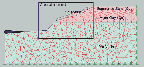
Figure 3. Model of the geometry and geologic layers of the Alki site. Double crosses indicate the model boundaries. Scale 1:3000.
Since the Alki landslide failed after heavy precipitation in the area it is assumed that rising groundwater levels were responsible for slide initiation. To simulate the effect of rising groundwater on the initiation of the Alki landslide a perched water table near the top of the relatively impervious Lawton Clay is raised in the finite-element model from 0-4 meters head to give a factor of safety of 1.07; a value close to the failure value of 1.
Figure 4. Finite-element mesh used to model the Alki landslide. Scale 1:3000.
Precise values for the cohesion of the colluvium are not available. Sensitivity results for a range of cohesion between 5KPa and 17 KPa for a perched water table of 4.0 m yields a best model fit for a cohesion of 15.1 KPa (the factor of safety for this value is 1.07).
|
Cohesion of the colluvium (KPa) |
Factor of safety (calculated with the phi/c reduction procedure) |
|---|---|
|
5 |
0.302 |
|
9 |
0.485 |
|
14 |
0.85 |
|
15 |
0.891 |
|
15.1 |
1.07 |
|
15.2 |
1.12 |
|
16 |
1.23 |
|
17 |
1.45 |
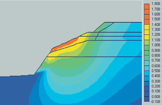
Predicted displacement magnitudes, [ux2 + uy2]1/2, (ux and uy are, respectively, horizontal and vertical displacements) when FS = 1.07 are shown in Figure 5. Displacements in this case are calculated using the elastic-Coulomb plastic algorithm in PLAXIS©.
Figure 5. Predicted displacement magnitudes in millimeters. Only the area of interest outlined in Figure 4 is shown. Displacements elsewhere are negligible.
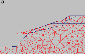
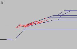
Figures 6a and 6b. Deformation of the mesh is shown in Figure 6a and displacement concentrations in regions at incipient failure are shown in Figure 6b.
The finite element modeling results give a general idea of the mechanism of landsliding at the Alki site in response to a rising perched groundwater table. The position and shape of the failure surface are simple; failure occurred on a surface at the contact between the colluvium and the clay and sand layers triggering a general movement of the colluvium which then mobilized into destructive debris flows.
In conclusion, we suggest that the slide occurred because of high pore pressures in the colluvium resulting from the juxtaposition of the weak colluvium on the transition zone between impervious Lawton clay and overlying Esperance Sand. Finally, although averaged and estimated geotechnical properties gave reasonable results for the Alki slide, a more complete sensitivity analysis for evaluating the effect of geotechnical property variation should be performed.
Baum, R.L., Chleborad, A.F., and Schuster, R.L., 1998, Landslides triggered by the winter 1996-97 storms in the Puget Lowland, Washington: USGS Open-File Report 98-239, 16 p.
Galster, R.W., and Laprade,W.T., 1991, Geology of Seattle, Washington, United States of America: Bull. of the Association of Engineering Geologists, v. 28, no. 3, p. 235-302.
Savage, W.Z., Baum, R.L.,Morrissey, M.M., and Arndt B.P., 2000a, Finite element analysis of the Woodway Landslide: Washington, U.S. Geological Survey Bulletin 2180. 9p.
Savage, W.Z., Morrissey, M.M., and Baum, R.L., 2000b, Geotechnical properties for landslide-prone Seattle-area glacial deposits: USGS Open-File Report 00-228, 5 p.
Shannon & Wilson, Inc., 2000, Geotechnical Report, Alki Avenue/Duwamish Head, stabilization project, Seattle, Washington, February 2000, 9 p.
Thorsen, G.W., 1989, Landslide provinces in Washington: in Richard W. Galster, ed., Engineering Geology in Washington: Washington Division of Geology and Earth Resources Bulletin 78, v. I, p. 71-89.
Tubbs, D.W., 1974, Landslides in Seattle: Washington Division of Mines and Geology Information Circular 52, 15 p., scale 1:31680.
Waldron, H.W., Liesch, B.A., Mullineaux, D.R., and Crandell, D.R., 1962, Preliminary geologic map of Seattle and vicinity, Washington: U.S. Geologic Survey Miscellaneous Geologic Investigations Map I-354, scale 1:31680.
| AccessibilityFOIAPrivacyPolicies and Notices | |
| |
|