DISCHARGE ESTIMATES
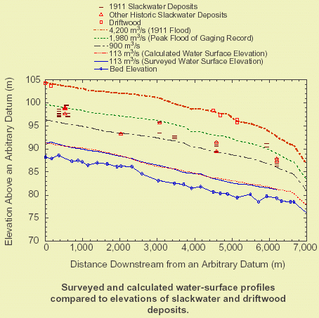
The abundant slackwater-deposit paleostage-indicators (SWD-PSI), particularly the driftwood lines, allow water-surface elevations of the 1911 flood to be known at many more points than are typically available in paleoflood studies on other rivers in the region. Paleoflood discharges typically are calculated using one-dimensional hydraulic models based on Manning-n roughness coefficients (Webb and Jarrett, in press). We measured 30 channel cross-sections spaced at 200-300 m (650-975 ft) intervals over a distance of 8 km (5 MI) that were designed to correspond to a surveyed water-surface profile from the SWD-PSI (Orchard, 2001). Low-water Manning-n coefficients were determined by calibrating a step-backwater model to a water-surface profile measured at a constant discharge of 113 m³/s (4,000 ft³/s). The Manning-n values were extended upwards to the SWD-PSI elevations by correlation with published photographs of channels with known roughness coefficients. Bedrock controls the entire cross section at the upstream end of the study reach, indicating that scour and fill is not significant, and an ancient debris fan and a severe constriction constrain hydraulic conditions to critical depth at the downstream end.
The abundance of SWD-PSI along the San Juan River allow the use of the slope-area method, which ordinarily is not appropriate for estimating discharges for paleofloods (Webb and Jarrett, in press). A particularly well-defined driftwood line near the center of the reach provided sufficient elevations to allow a slope-area estimate using 3 of the 30 cross sections. Using the slope-area method, the discharge of the 1911 flood was estimated to have a discharge of 4,350 m³/s (154,000 ft³/s). The step-backwater analysis used all 30 cross sections and estimated a discharge of approximately 4,200 m³/s (148,000 ft³/s) for the 1911 flood.
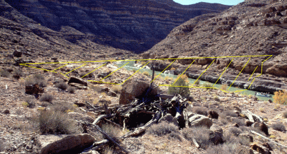 |
| Driftwood is one of the primary paleostage indicators used to reconstruct the 1911 flood discharge. The highest-elevation flood deposits in the study area are driftwood lines that contain both sawn wood, nails, and metal cans. The hashed area shows the approximate cross-sectional area and stage of a 4,200 m³/s 148,000 ft³/s) discharge. Abundant driftwood in the foreground is piled on the upstream side of a rock, indicating flow along the shore was downstream and the entire cross section was part of the effective flow area. The raft in the center right of the frame is 6 m (18 ft) long, and the discharge in the photo is 25 m³/s (~900 ft³/s). |
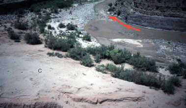 |
| This downstream view shows Eight-Foot Rapid, the downstream control section for the step-backwater model of the 1911 and other floods. Features preserved here include (A) an ancient debris fan, (B) a younger debris fan, and (C) slackwater deposits in the form of an extremely large reattachment bar. |
 |
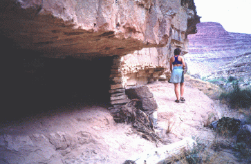 |
| This structure at mile 13.2 is buried by a flood deposit. The structure may be historic or related to Ancestral Puebloan use of San Juan Canyon. Other structures provide evidence that all the flood deposits in San Juan Canyon upstream from Mexican Hat are historic. |
