REPEAT PHOTOGRAPHY
We matched a total of 74 historical photographs between Bluff and Mexican Hat. The main purpose of matching these photographs was to evaluate long-term changes in riparian vegetation in this reach. The following 15 sets of photographs illustrate the changes we observed in the riparian vegetation along the San Juan River.
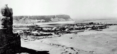 |
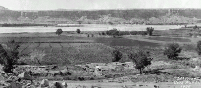
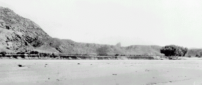
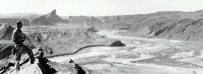
| (1890s). This downstream view, with the Navajo Twins rock formation at left, shows Bluff in the early 1890s and the wide and denuded channel of the San Juan River in the middle distance. Scattered groves of trees line the channel, which in places is about 400 m (1,300 ft) wide. Bluff was founded in 1880, more than a decade before this photograph (Charles Goodman 64, courtesy of the University of Utah Marriott Library). |
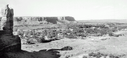 |
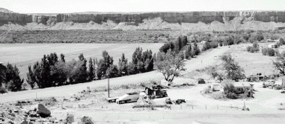
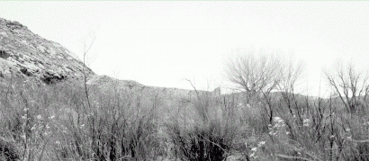
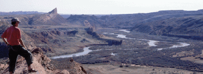
| (July 2, 2000). The channel of the San Juan River is no longer visible from this vantage point. The floodplain is clogged with riparian vegetation, both native and nonnative species. Cottonwoods (Populus fremontii) are locally abundant in this reach, but the most widespread species are coyote willow (Salix exigua) and nonnative tamarisk (Tamarix sp.); Russian olive (Elaeagnus angustifolia) is locally abundant. Trees have grown in town also, blending with the riparian vegetation (Dominic Oldershaw, Stake 2858). |
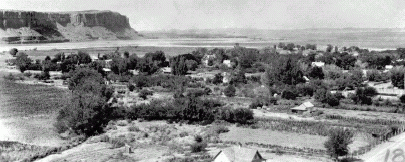 |
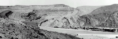
| (July 15, 1921). This view, taken in approximately the same direction as the previous one but upstream from the Navajo Twins, shows that the channel of the San Juan River was free of riparian vegetation in 1921. The trees in Bluff are taller than in 1890, and the town appears to be considerably larger (Robert N. Allen 18, courtesy of the USGS Photo Library). |
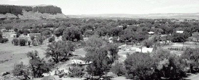 |
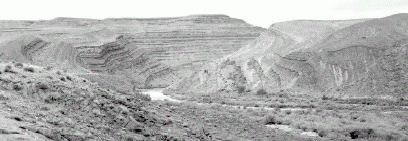
| (July 2, 2000). The San Juan River channel is completely obscured by riparian vegetation. Both native and nonnative species densely cover the former floodplain (Dominic Oldershaw, Stake 3524). |
 |
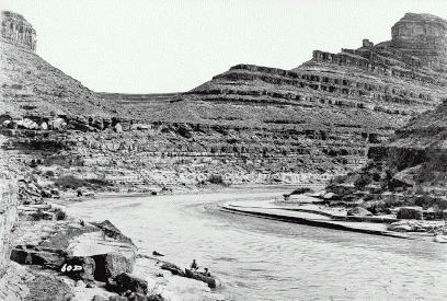
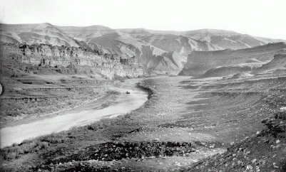
| (1909). This view, from approximately the same position as the previous photograph but angled across the San Juan River, shows the channel beyond cultivated agricultural fields. Broad islands vegetated with low-statured riparian vegetation appear in the channel at both the left and right sides of the view. Scattered trees, probably cottonwoods, are visible across the channel in the center. This photograph was taken just before the 1909 flood (Stuart Malcolm Young NAU.PH.643.1.2, courtesy of Northern Arizona University Cline Library). |
 |
| (July 2, 2000). The main highway from Bluff to Blanding appears in the foreground, and agricultural fields continue to be tilled in this area. The channel of the San Juan is obscured in a sea of riparian plants, mostly tamarisk, willows, and scattered cottonwood trees. Note that the former islands appear to have denser riparian vegetation than the formerly barren areas (Dominic Oldershaw, Stake 2359a). |
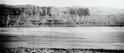 |
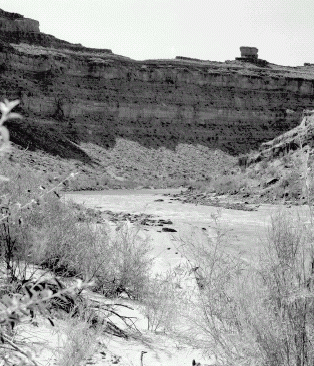
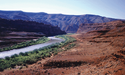
| (1925). West of Bluff, the San Juan River flows beneath bluffs of Page Sandstone. This view, from the old road between Bluff and Mexican Hat, faces due south from a terrace above the right bank. Flow is from left to right. The channel is broad and almost entirely free of vegetation, with numerous secondary channels; the main channel is probably directly beneath the distant bluffs (Lee 3172, courtesy of the USGS Photo Library). |
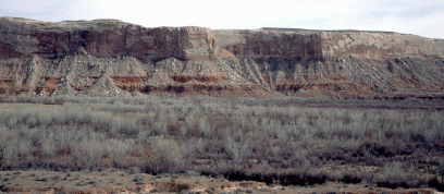 |
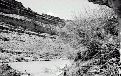
| (March 22, 1998). The channel of the San Juan River has narrowed considerably, and all secondary channels have disappeared. Most of the vegetation is tamarisk and Russian olive, although coyote willows line the active channel (Robert H. Webb, Stake 3522a). |
 |
| (ca. 1927) The original view was taken from the mouth of Comb Wash looking southwest toward the Mule's Ear diatreme (center). The flowing water is almost indistinguishable from the sandy channel, but the river is flowing beneath the cutbank in the middle distance. The channel here is wide and vegetation free except for small cottonwoods at right (Herbert E. Gregory 536, courtesy of the USGS Photo Library). |
 |
| (March 23, 1998). The view is now blocked by riparian vegetation, including nonnative tamarisk (taller trees) and native rabbitbrush (Chrysothamnus nauseosus; white flower heads). The cottonwood trees, leafless in March, appear in the right midground. The cottonwoods in the original view are no longer present, but new cottonwoods are in approximately same location (Robert H. Webb, Stake 3525). |
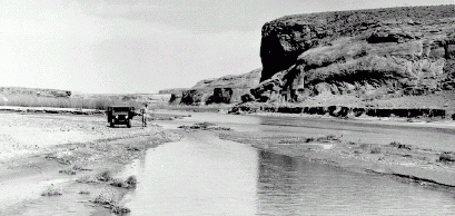 |
| (March 1953). This upstream view of the San Juan River shows the mouth of Comb Wash (left midground, just beyond the jeep). Short-statured riparian plants with the appearance of coyote willow line both the San Juan and the upstream side of Comb Wash. This photograph was taken 9 years before completion of Navajo Reservoir (Gregory C. Crampton PO197:52:1:21, courtesy of the University of Utah Marriott Library). |
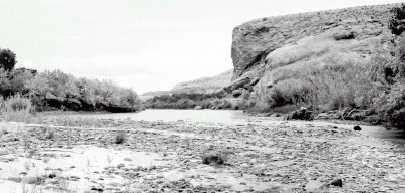 |
| (August 26,1997). Considerable riparian vegetation is now present throughout this view, and Comb Wash drains into a shallow distributary channel north (river right) of the main river channel. Both native and nonnative riparian vegetation have increased; coyote willow generally is the shrub closest to the river channel, with Russian olive and tamarisk just behind. Cottonwood trees are present on the closest terraces to the river on both sides (Dominic Oldershaw, Stake 2285). |
 |
| (March 1953). The photographer is standing on "San Juan Hill," a promontory just upstream from the confluence of Comb Wash (right foreground), and the view of the San Juan River is downstream. The Mule's Ear diatreme is at left center, and the entrance to San Juan Canyon is at right center; Chinle Wash joins the San Juan River at about the point where the river disappears from view. The channel of the San Juan, which was obviously much wider, has narrowed recently; note the sharp cutbank across the river in the center of the photograph and low cutbanks and floodplains. Low-statured riparian vegetation is becoming established along both drainages; a lone cottonwood appears at lower center (Gregory C. Crampton PO197:52:1:36, courtesy of the University of Utah Marriott Library). |
 |
| (March 23, 1998). The channel of both the San Juan River and Chinle Wash have narrowed considerably. In this reach, the channel of the San Juan is divided through a series of islands densely covered with riparian vegetation. Cottonwood trees are difficult to identify in this late-winter view, but they are present along most of the channel, particularly along river right (Dominic Oldershaw, Stake 3558). |
 |
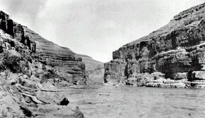
| (July 19, 1921). This downstream view, downstream from the confluence with Chinle Creek, shows the entrance to San Juan Canyon. The channel is wide with broad sand bars. A high terrace on river right is covered with dense, low vegetation that could be either coyote willows, young tamarisk, or native shrubs such as rabbitbrush; several young cottonwoods are present on the far bank (river right). This photograph was matched in 1973 (Baars, 1974, p. 67), and riparian vegetation had begun encroaching on the river channel at that time (Hugh D. Miser 415, courtesy of the USGS Photo Library). |
 |
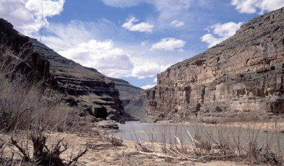
| (August 26, 1997). The channel has narrowed significantly, both between 1921 and 1997 and especially between 1974 and 1997. The cottonwood trees present in 1921 have greatly increased in size, and tamarisk and Russian olive cover the floodplains. Russian olive is relatively sparse in the canyons downstream (Dominic Oldershaw, Stake 2286). |
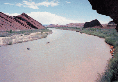 |
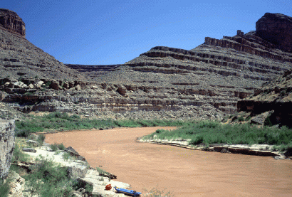
| (1985). This upstream view, just downstream from the confluence of Chinle Wash and the San Juan River, shows the small boats of a commercial river trip. The river trip participants are likely hiking to the Mule's Ear diatreme, which is out of this view to the right. By 1985, riparian vegetation was relatively dense in this reach (Bill Belknap NAU.PH.96.4.318.8, courtesy of the Northern Arizona University Cline Library). |
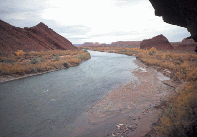 |
| (October 28, 1999). Riparian vegetation has increased considerably in the 14 years since the 1985 photograph. Much of the increase is in nonnative tamarisk, but cottonwood trees on both sides of the river have also increased in size. The gravel bar exposed on river left (right center) is not new but merely exposed in the low discharge of 23 m³/s (822 ft³/s) of this view (Dominic Oldershaw, Stake 3933). |
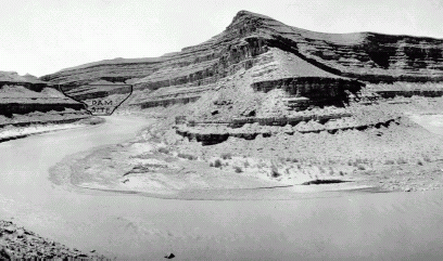 |
| (1921). Eugene C. LaRue, a USGS hydrologist, took this photograph of the San Juan River about 3 km (2 MI) downstream from the entrance to the canyon to document a potential damsite. This upstream view, which is the left center cropped from LaRue's wider view, shows the dam hand drawn on the photograph. Very little riparian vegetation is present in this reach, and the pointbar across the river appears scoured (Eugene C. LaRue 827, courtesy of the USGS Photo Library). |
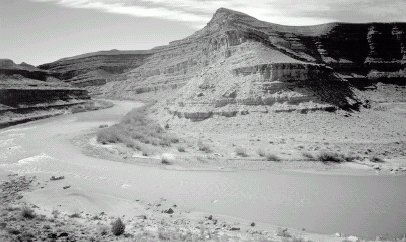 |
| (March 24, 1998). At this low water level of less than 28 m³/s (1,000 ft³/s), a line of pourovers marks the first rapid of note in San Juan Canyon. The formerly denuded point bar is covered with riparian vegetation, much of which is nonnative tamarisk (Dominic Oldershaw, Stake 3560a). |
 |
| (July 19, 1921). One of the USGS expedition boats is beached in a broad eddy in this upstream view of 4-Foot Rapid. Very little riparian vegetation is visible, and what is present are low-statured shrubs. A clear high-water mark appears in the middle distance, probably as a result of the 1911 and other floods (Hugh D. Miser 418, courtesy of the USGS Photo Library). |
 |
| (August, 27, 1997). The increased vegetation is almost entirely native coyote willow, but a distinctive branch of a solitary Russian olive appears at the left. Tamarisk has become established on both sides of the channel in the middle distance. Despite the substantial channel narrowing several miles upstream, the channel has not narrowed appreciably here, and the increase in riparian vegetation is not as large as in the alluvial reaches between Bluff and the entrance to the canyon. The light high-water mark has faded, obscured by desert vegetation (Dominic Oldershaw, Stake 2288). |
 |
| (1941). A boat used by Norm Nevills on his pioneering river expeditions on the San Juan appears in this upstream view from the start of our study reach. Scattered stands of dense riparian vegetation are present on both banks, separated by scoured bedrock or barren sand. Some of the taller plants on the far bank (river left) likely are netleaf hackberry (Celtis reticulata), a small, native tree. This view does not show a significant change in density or cover of riparian vegetation in comparison with other photographs taken between 1875 and 1921 (Phillip W. Tompkins PO341:7:14:5, courtesy of the University of Utah Marriott Library). |
 |
| (August 27, 1997). Riparian vegetation has increased greatly, particularly on the point bar at right center. Tamarisk has increased the most, although native species such as coyote willow are also present. A lone juniper appears under the cliff upslope from the point bar (Dominic Oldershaw, Stake 2289) |
 |
| (1875). This upstream view, one of the first photographs of the San Juan River, shows high-elevation flood deposits on the far side of the river (left midground). These flood deposits were emplaced before the 1911 flood (William Henry Jackson 57-MS-538, courtesy of the National Archives). |
 |
| (August 27, 1997). Most of the new vegetation is coyote willow, with scattered tamarisk trees on the far bank. The flood deposits are no longer prominent, being obscured by native grasses and desert shrubs. Driftwood, some of which was deposited by the 1911 flood, is about 13 m (42 ft) above the low-water channel on the slope leading to the background cliffs (Dominic Oldershaw, Stake 2290). |
 |
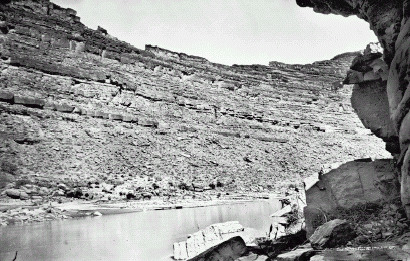
| (1921) This downstream view shows the entrance to First Narrows and is just downstream from Eight-Foot Rapid. Our study reach ended at the entrance to First Narrows. The scattered riparian vegetation (left side) appears to be mostly netleaf hackberry trees (Robert N. Allen 27, courtesy of the Dan O'Laurie Museum). |
 |
| (March 24, 1998). The original camera station is buried under a new sand bar; our camera station is about 1.2 m (4 ft) too high. Coyote willows line the river, with tamarisk just visible behind the willows. Beaver had culled some of the willows from the sandbar shortly before our visit (Robert H. Webb, Stake 3529). |
 |
| (December 1894). This downstream view of the San Juan River is taken from a point on a cliff of Moenkopi Formation just upstream from the Mexican Hat. A gold dredge is visible in the center of the river in the midground. The channel is relatively wide and braided around sandbars in this reach. Other photographs taken at this time indicate that the riparian vegetation on the terraces (both sides of the river) are native coyote willow, leafless in winter (Charles Goodman PO068:78, courtesy of the University of Utah Marriott Library). |
 |
| (July 3, 2000). Riparian vegetation has increased significantly on both sides of the river, resulting in significant channel narrowing. This reach is only partly bedrock controlled and has responded similarly to the reach from Bluff to the head of the canyon, both in terms of increases of riparian vegetation and channel narrowing. The vegetation consists of native coyote willow closest to the river channel and on the point bar in the middle distance where the dredge once was; a band of dense tamarisk occurs behind the willows. The floodplain consists of a mixture of native shrubs and smaller tamarisk (Dominic Oldershaw, Stake 1790). |
