 Introduction Introduction
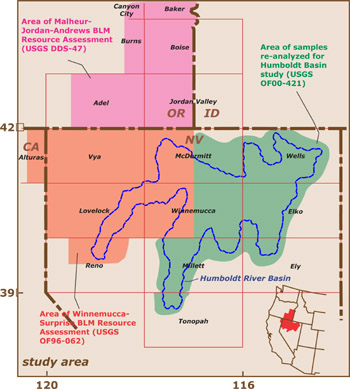
This report presents geochemical data generated during mineral and environmental assessments for the Bureau of Land Management in northern Nevada, northeastern California, southeastern Oregon, and southwestern Idaho, along with metadata and map representations of selected elements. The dataset presented here is a compilation of chemical analyses of over 10,200 stream-sediment and soil samples originally collected during the National Uranium Resource Evaluation's (NURE) Hydrogeochemical and Stream Sediment Reconnaissance (HSSR) program of the Department of Energy and its predecessors and reanalyzed to support a series of mineral-resource assessments by the U.S. Geological Survey (USGS). The dataset also includes the analyses of additional samples collected by the USGS in 1992.
The sample sites are in southeastern Oregon, southwestern Idaho, northeastern California, and, primarily, in northern Nevada. These samples were collected from 1977 to 1983, before the development of most of the present-day large-scale mining infrastructure in northern Nevada. As such, these data may serve as an important baseline for current and future geoenvironmental studies. Largely because of the very diverse analytical methods used by the NURE HSSR program, the original NURE analyses in this area yielded little useful geochemical information. The Humboldt, Malheur-Jordan-Andrews, and Winnemucca-Surprise studies were designed to provide useful geochemical data via improved analytical methods (lower detection levels and higher precision) and, in the Malheur-Jordan-Andrews and Winnemucca Surprise areas, to collect additional stream-sediment samples to increase sampling coverage.
The data are provided in *.xls (Microsoft Excel) and *.csv (comma-separated-value) format. We also present graphically 35 elements, interpolated ("gridded") in a geographic information system (GIS) and overlain by major geologic trends, so that users may view the variation in elemental concentrations over the landscape and reach their own conclusions regarding correlation among geochemistry, geologic features, and known mineral deposits. Quality-control issues are discussed for the grids and data.
|
First posted August 31, 2001
Part or all of this report is presented in Portable Document Format (PDF). For best results viewing and printing PDF documents, it is recommended that you download the documents to your computer and open them with Adobe Reader. PDF documents opened from your browser may not display or print as intended. Download the latest version of Adobe Reader, free of charge.
|

