
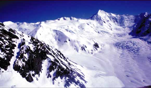
Aerial view of Hayes Volcano in the Tordrillo Mountains near Mount Gerdine (highest peak in background). Most of the volcanic cone of Hayes Volcano was destroyed during the most recent eruption of the volcano, about 3,600 years ago. Because the remaining parts of the cone are obscured by glacier ice and snow, identifying the volcano is difficult. Photograph taken by author T.P. Miller, September 1981.
|
Hayes Volcano is an ice- and snow-mantled, deeply eroded volcanic massif located in the northern Tordrillo Mountains of the north-central Cook Inlet region about 135 kilometers northwest of Anchorage, Alaska. Hayes Volcano consists of a glacially dissected, poorly exposed cluster of lava domes. No historical eruptions of Hayes Volcano are known, and the last period of major eruptive activity occurred within a time interval of 4,400 to 3,600 years ago. During this period, explosive Plinian-style eruptions occurred that dispersed volcanic ash over large areas of interior, south-central, and southeastern Alaska. Pyroclastic flows produced during these eruptions descended Hayes Glacier and entered the Hayes River drainage. The pyroclastic flows initiated volcanic debris flows or lahars that flowed down the Hayes River, into the Skwentna River, and probably reached the Yentna River about 110 kilometers downstream from the volcano. The last major eruptive period of Hayes Volcano may have spanned about 200 years, and at least one of the eruptions during this interval was possibly the largest eruption of any volcano in the Cook Inlet region in the past 10,000 years. The distribution and thickness of volcanic-ash deposits from Hayes Volcano in the Cook Inlet region indicate that volcanic-ash clouds from prehistoric eruptions were voluminous. Clouds of volcanic ash generated during a future eruption of Hayes Volcano would be a major hazard to all aircraft using Ted Stevens Anchorage International Airport and other local airports, and, depending on wind direction, ash clouds could drift a considerable distance beyond the volcano. Ash fallout from future eruptions could disrupt many types of economic and social activities, including oil and gas operations, shipping activities, and power generation in the Cook Inlet area. An eruption of Hayes Volcano-even a minor episode- would likely melt a significant amount of ice and snow, and the meltwater could result in the formation of large lahars and downstream flooding. The greatest hazards in order of importance are summarized below and are shown on plate 1. |
Download the Pamphlet portion of this report as a PDF document (33 pages; 3.8 MB)
Download the Plate at screen resolution. To speed your downloading at the expense of print quality, this file, pl1-scrn.pdf, is a low-resolution version that looks good on the computer monitor but will not look clear printed on a plotter. 36 x 24 inch PDF document (7.3 MB).
Download the Plate at print resolution. To give you high print quality at the expense of download speed, this file, pl1-plot.pdf, is a high-resolution version that prints well on a plotter. 36 x 24 inch PDF document (65 MB).
For questions about the content of this report, contact Christopher Waythomas
| Help
| PDF help
| Publications main page | Open-File
Reports for 2002 |