
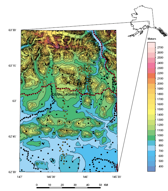
During the summer of 2001, a gravity survey was conducted in the vicinity of Tangle Lakes, east-central Alaska. Measurements of 87 gravity stations were made. The Tangle Lakes area is located about 25 km west of Paxson and north of the Denali Highway. The gravity survey is located on the southwest corner of the Mt. Hayes and the northwest corner of the Gulkana 1:250,000 scale USGS topographic maps. The boundaries of the study area are 62° 30’ to 63° 30’ N. latitude and 145° 30’ to 147° 00’ W. longitude. A map showing the location of the study area is shown in figure 1. One gravity base station was used for control for this survey. This base station, TLIN is located at the Tangle Lakes Inn. The observed gravity of this station was calculated based on multiple ties to base stations ANCU in Anchorage, PALH in Palmer, BD27 in Gulkana, and base stations D42, and D57 along the Denali Highway.
Download the 22-page report as a PDF document (1.3 MB)
Download the data package as a .zip document (47 KB)
Download the metadata file as a .txt document (13 KB)
For questions about the content of this report, contact Bob Morin
Download a free copy of the latest version of Adobe Reader.
| Help
| PDF help
| Publications main page | Western Open-File Reports for 2002 |
|
Privacy Statement | Disclaimer
| Accessibility |
|
Department of the Interior | U.S.
Geological Survey | Geologic Division
| Geophysical Investigations
|
This report is available only on the web