| |  |  | | Lake Pontchartrain Atlas: | | | | | | | | | | | | | Environmental Overview |  | | | | | | | | | | | | | | | | | | | | | | | | | | | | | | | |  | | | | | | | | | | |  | Environmental Overview - Regional Description of the Lake Pontchartrain Basin Contributors: Penland, McCarty, Beall, Maygarden 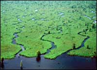 | | Figure 8: Freshwater marsh shoreline of Lake Maurepas. | The values of the wetlands in the Lake Pontchartrain Basin are well established. Biologically, they provide much of the energy needed to run the Lake Pontchartrain ecosystem and are therefore essential for sustaining the fisheries resources. However, the wetlands of the Lake Pontchartrain Basin have declined by about 50% since 1900 (Stone, 1980). Wetland loss occurs throughout the Lake Pontchartrain Basin due to a variety of causes (Penland et al., 1990; Penland et al., 2000a; Penland et al., 2000b). Wetlands can be lost by conversion to a different non-wetland landscape type as discussed above or by being converted to open water. Although natural processes have contributed to some of this loss, much of it can be attributed to human activities. Some of the wetland losses can be directly traced to dredging or filling of these areas. Salt water introduced through the MRGO and the Inner Harbor Navigation Canal (IHNC) is damaging the freshwater marshes and swamps around Lakes Pontchartrain and Maurepas (Figure 8). With the increasing population on the north shore and other areas within the Basin, additional wetland acreage is continually being threatened. Shoreline erosion rates vary considerably throughout the Basin (Adams, 1978). Because of shoreline stabilization, there is little shoreline erosion in Jefferson and Orleans Parishes. Shoreline erosion, however, is a problem throughout the lakes. Areas of greatest shoreline erosion are the Chandeleur Islands and the shores of Chandeleur and Breton Sounds (Williams et al., 1993). « Previous | Next » |
