| |  |  | | Lake Pontchartrain Atlas: | | | | | | | | | | | | | | | | Environmental Status & Trends |  | | | | | | | | | | | | | | | | | | | | | | | | | | | | |  | | | | | | | | | | |  | Environmental Status and Trends - Status and Trends of the Lake Pontchartrain Basin Contributors: Penland, Maygarden, Beall 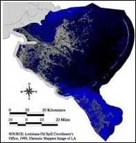 | 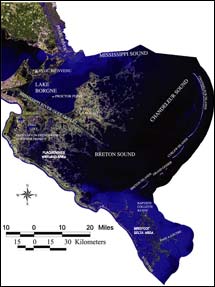 | | Figure 13. (above) Satellite image of the Mississippi River Deltaic Plain geomorphic region of the Lake Pontchartrain Basin. Click on the image for a larger version. | | Figure 14: (right) Satellite image labeled with the areas and rivers that are mentioned throughout the section for the Mississippi River Deltaic Plain Region. Click on the image for a larger version. | The areas contained in the Mississippi River Deltaic Plain geomorphic region are associated with the delta-building cycle of the Mississippi River and are removed from Lake Pontchartrain itself (Figures 13 and 14). The Mississippi River Deltaic Plain Region is divided into the following geographic areas: Central Wetland, South Lake Borgne, Lake Borgne, St. Bernard Wetland, Breton-Chandeleur Sound, Chandeleur Island, Plaquemines Wetland and Birdfoot Delta (Figure 1). The Central Wetland, Lake Borgne, South Lake Borgne and Chandeleur Island Areas are all part of the St. Bernard Delta. The river naturally abandoned this older delta lobe when it switched its course some 2,000 years ago and began building the LaFourche Delta. Consequently, land building declined in this portion of the Lake Pontchartrain Basin well before European settlement began. USACE data show relative sea level rise in the region ranging from less than 0.15 m (0.5 ft) per century to 0.3 to 1.2 m (1-4 ft) per century, making it the most rapidly subsiding portion of the Lake Pontchartrain Basin (see Regional Long-Term Relative Sea Level Rise Rates). The Chandeleur Islands mark the outer edge of this system, but have long been migrating landward. The Plaquemines Wetland and Birdfoot Delta Areas of the region are part of the Modern delta of the Mississippi River (Figure 1). The Birdfoot Delta continues to be naturally influenced by the fresh water and sediment of the Mississippi River, while the Plaquemines Wetland Area receives river water by virtue of the Caernarvon Freshwater Diversion Project.
« Previous | Next » |
