Moored Array
Measurements were made at 6 stations, four along the axis
of the valley (Stations A, B, C and F), and two on the shelf
to the east and west (Stations D and E) (figure
1) (Table).
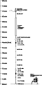
Schematics of the mooring are shown in figures 2A,
2B,
2C,
2D,
2E,
and 2F.
The moored array was deployed from the RV Oceanus
between December 3-7, 1999, and recovered on RV
Endeavor between April 14-18, 2000. The recovery system
failed on the tripod at Station B; the instrument was recovered
with a remotely operated vehicle using the RV
Connecticut on June 28, 2000.
At all stations, upward-looking Acoustic Doppler Current
Profilers (ADCP's) were deployed on bottom tripods.
At Stations A-E temperature and conductivity was measured
at 1 meter below the surface (mbs) using MicroCAT's.
Temperature, conductivity, and light transmission were measured
at 30 and 45 mbs at Station B (25 and 10 meters above the
bottom (mab)) and at 30 and 60 mbs
(40 and 10 mab) at Station C. Near-bottom currents
were measured at Stations A, B, and C, using Benthic Acoustic
Stress Sensors (BASS's) at 0.4 and 1.0 mab,
and at Stations D and E at 0.4 mab using Modular
Acoustic Velocity (MAV) sensors. Downward looking profiling Acoustic Backscatter Sensors (ABS) were mounted 115 cm above the seabed on the tripods at stations A, B, and D. Near-bottom
measurements of temperature, conductivity, pressure, and optical
backscatter were also made at Stations A-E. Near-surface
and subsurface measurements were made from moorings below surface
buoys that were deployed at Stations A-E. These buoys also marked the sites to help prevent entanglement with fishing activity.
Hydrography
Conductivity/temperature/depth (CTD) profiles
were obtained on the moored array deployment cruise on RV
Oceanus between December 5-7, 1999 (figure
3, Table [PDF, Excel] ), and on the instrument recovery cruise on the
RV Endeavor on April 15, 2000 (figure
4, Table [PDF, Excel] ). Measurements were made with a Sea Bird SBE11
profiling CTD sensor. On the RV
Oceanus cruise, profiles of light transmission and
optical backscatter were also obtained and on the RV
Endeavor cruise, profiles of light transmission and
fluorescence were obtained. Water samples were obtained at
selected stations and depths and filtered through pre-weighed
0.4 micron nucleopore filters to determine suspended matter
concentration (Oceanus
concentrations) (Endeavor concentrations). The measured concentrations were used
to determine calibrations for the optical backscatter (OBS)
and transmission sensors.
Site Surveys
Surveys of the sea floor at each mooring site were carried out using a multibeam sea floor mapping system to provide detailed maps of bathymetry and backscatter intensity. The multibeam surveys were carried out as part of a larger survey of the New York Bight and the Hudson Shelf Valley (Butman and others (1998), Butman (1998), Butman and others (2002), and USGS Studies in the New York Bight). The surveys were carried out using a Simrad EM 1000 sea floor mapping system mounted on the survey vessel Frederick G. Creed. The surveys at sites A, B, C and F were carried out in 1996 and 1998 prior to the Hudson Shelf Valley winter experiment and were used to help locate the instruments in the axis of the valley. Multibeam surveys at sites D and E on the continental shelf were carried out in April 2000 after the instruments were retrieved. Backscatter intensity from a sidescan sonar survey of the New York Bight Apex was used to help place these instruments (see Schwab and others, 2000).
Bottom photographs, videos and sediment samples of the sea floor were obtained on the mooring deployment (RV Oceanus, December 1999) and recovery cruises (RV Endeavor, April 2000) to show the character of the sea floor. These observations were made using the SeaBed Observation and Sampling System (SEABOSS) (Valentine and others (2000), Blackwood and Parolski (2002)). SEABOSS is equipped with two video cameras, a still camera, a pressure-depth sensor, and a modified Van Veen sediment grab sampler. At each station, the SEABOSS was lowered to a target elevation about 76 centimeters (30 inches) above the sea floor and the ship allowed to slowly drift, typically for a few hundred meters. As the ship drifted, typically at a knot or less, bottom video was recorded continuously and individual photographs of the sea floor were triggered remotely based on the video available in real time at the surface. Typically 5-50 still photographs were obtained at each station. At 76 centimeters above the bottom, the still photographs show a 76 x 51 centimeter area of the seafloor. At most stations, a single sample of the sediment was obtained using the Van Veen sampler, typically at the end of the transect. At some locations, cobbles and boulders on the seafloor made sampling impossible. The upper 2 cm of the sediment were skimmed from the grab sample and analyzed for texture using the methods outlined in Poppe and others (2000). Additional photographs and videos from these and other stations in the New York Bight may be found in Butman and others (in press).
|
|