Geological Survey of Canada, Québec Division
880 Chemin Ste-Foy
Québec City, Québec, Canada G1V 4C7
Telephone: (418) 654-3705
Fax: (418) 654-2615
e-mail: eboisver@nrcan.gc.ca, amorin@nrcan.gc.ca, manctil@nrcan.gc.ca
This technique has been used by Davenport (this volume) to build an emerging encoded science language. He established that certain geological concepts are best described by the union of several concepts. For example, a rock type can be described by a conjunction of material, genesis, and texture/fabric. A map unit can in turn be described by a collection of rock types and an age. The cascading effects of linking one concept to other concepts allows the linking of a map unit with genesis (and genesis to environment, and so forth). This technique seems intuitively closer to the way geological information is structured. The approach used in the GEOMDB prototype seems profitable because this small improvement in the data model opens a realm of possibilities, such as dynamic reclassification (for example, unit into ages: because the unit concepts are related to age concepts, it's possible to reclassify units as ages) and the possibility to query the database about the possible relationships between concepts even if the relationship is not encoded in a single database. The map unit-age relationship could lie in one database, and the map unit-genesis relationship could reside in another. Joining the results of both databases, a user could find where a particular genesis is found at a specific time, even if this information is not explicitly coded in one database instance.
Boisvert and others (2001) noted "we are of course toying with the idea of using XML as an exchange mechanism," and, in this year's work, we did indeed. This first prototype exchanged specially formatted HTML pages (actually, snippets of pages), and converting this information to XML added a new dimension to the project: the possibility to process rather than simply to display the result. The original approach used only a single mediator software (the piece of software that translates the database content into an HTML page) and the resulting set of pages was merely reassembled and displayed. Using XML we can now ask another mediator to receive the series of XML responses and process them, and do something useful with the result. Using XML also allows software other than browsers to use the server response.
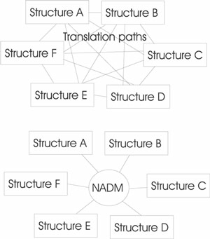
This opens another set of possibilities in database interoperability. This approach relies on a translation mechanism that brings information stored in structure A to a portable format that can be translated back to structure B with another translator. This "lingua franca" method is already used by software like FME (http://www.safe.com/) where a common format (based on SAIF) is used as a launch point toward another format. Our goal for geological information is to use NADM-Cord as a lingua franca between database structures. Because the goal for CGKN is to share database content, the goal for a specific agency participating in this exchange is to provide a mechanism to translate its local structure into NADM-Cord concepts and constructs (Figure 1). This is done usually through the creation of mediators, which are pieces of software that translate back and forth between NADM-Cord and local structure and content. Developments made during the past year advanced further the concept of connecting distributed databases using an emerging concept called Web services.
|
Figure 1. NADM-Cord as an interchange language between various database implementation. The top part of the figure shows a brute-force solution for interoperability; the bottom part shows our vision. |
Figure 2 shows schematically how this service can be used to synchronize information between a central database and a local database. The call to the service is done through a regular URL2 to a specific page, which activates a ColdFusion script. These scripts operate on the database and generate responses formatted in XML, which Geomatter parses back, making the necessary adjustment to the user interface (that is, creating a visual representation of the information). This is a good example in which the client of the service is not a Web browser. The user working on Geomatter never sees the XML and is not aware that a conversation is being held between Geomatter and the Web server; the user is shielded by a user interface that displays familiar Windows controls.
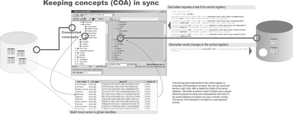
Figure 2. Geomatter as a client of a service. Geomatter calls the concept "manipulation service" and can manipulate the content of the central registry through a series of operations. The server side is encoded using ColdFusion scripts that interact with the database and return results to Geomatter using XML formatted pages. |
In Figure 3, the central portal receives a request to find maps that contain a certain geological concept. This request is passed to all local databases, which return an XML segment as a response. The central database can then easily merge XML segments and present a single response to the issuer of the request. The XML (Example 1) contains all necessary information to locate the map through a standard Web Mapping Service (WMS) call. The WMS is an Open GIS Consortium (OGC) standard to request maps over the Internet (OGC-WMS, 2000); this technology is gaining wide acceptance among GIS vendors.
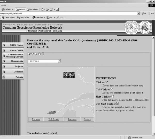
Figure 3. Web site as a client of a service. The content of this page is the result of a series of calls made to various services. The application is interacting with a server that merges information from various servers using Web services. |
Example 1. Sample of a XML response from the server.
<?xml version="1.0"?>
<MAPLIST CLIENT="SIMPLE_MAPSERVICE">
<!—this is where on the web the map is→
<MAP SRC="http://www.cgq-qgc.ca/cgi-bin/mapserv_35s.exe?map=d:/webcgq/hydrolink/data/maps/production/english/surf_wms.map">
	Surficial geology of Canada
<!—This is its full name→
<NAME>Surficial geology of Canada</NAME>
	<!—this tell us that the map can be accessed using WMS protocol→
	<TYPE>WMS</TYPE>
	<!—the projection of the source map, using EPSG3 codes→
	<PROJ SRS="EPSG:4269" />
	<!—the limits of the map→
	<BBOX XMIN="-140.0" YMIN="40.0" XMAX="-40.0" YMAX="85.0" />
		<!—and a list of layers composing the map→
		<COVERS>
		<COVER NAME="10002">Surficial Geology of Canada</COVER>
		</COVERS>
</MAP>
<!—and we continue with the next map→
<MAP SRC="http://www.cgq-qgc.ca/cgi-bin/mapserv_35s.exe?map=d:/webcgq/hydrolink/data/maps/production/english/piedmond_wms.map">
	Carte des formations de surface de Portneuf
	<NAME>Carte des formations de surface de Portneuf</NAME>
	<TYPE>WMS</TYPE>
	<PROJ SRS="EPSG:4269" />
	<BBOX XMIN="45.5" YMIN="-71.5" XMAX="45.0" YMAX="-70.5" />
		<COVERS>
		<COVER NAME="10006">Unité geologie de surface</COVER>
		<COVER NAME="10009">Forages</COVER>
		<COVER NAME="10031">Station GIMS</COVER>
		</COVERS>
. . .continues. . .
This XML segment can be consumed by any application that can parse XML tags. We coded a simple consumer (a consumer is a service user, to extend the business metaphor; this term is widely used in Web service literature) that can merge a selected list of maps into a single view (Figure 3), but because this has been established as a service, other applications can use it. For instance, someone writing software in Visual Basic might want to use this service and call it from within its code; the service is totally independent of which client is using it. The map is not trapped in this Web page. Other applications can use the service and extract the map. For instance, we wrote a small application that can read this service back and build a composite view of maps aggregated from a single query to the central registry.
Example 2. Response for a GetFeatureInfo.
<xml version='1.0' encoding="UTF-8" standalone="no" ?>
<NADM VERSION="5.2" xmlns="http://www.cgkn.net/NADM">
<!—A feature_block is created for every spatial object in the list -->

<FEATURE_INFO>
<DBSOURCE xmlns:xlink="https://www.w3.org/1999/xlink" xlink:type="simple" xlink:href="http://www.cordlink1.org">

<REQUEST MODE="SELECT">
 <SOURCE SOURCE_ID="24">Geological Map Of Canada</SOURCE>
 <NADM_DATASET DATASET_ID="56">Geology
 <SPATIAL_OBJECT_ID ID="100">
 </NADM_DATASET>
 <NADM_SERVICE URL="http://www.cordlinkg.org"/>
</REQUEST>

<CLASSIFICATION SCHEME_ID = "125" CLASS_OBJ_ID="1265">
 <CLASS_LABEL>Dst</CLASS_LABEL>
 <CLASS_NAME>Talwar Formation</CLASS_NAME>
 <COA COA_ID = "55">Talwar Fmt
 <COA_ATT DESC_TYPE="IMAGE" DESC_ID="25"/>
 <COA_ATT DESC_TYPE="IMAGE" DESC_ID="56"/>
 <COA_ATT DESC_TYPE="TEXT" DESC_ID="1123"/>
 </COA>
 <COA_REL COA_REL_TYPE="ROCK COMPOSITION" COA_ID = "225">Calcarous limestone</COA_REL>
 interbedded with <COA_REL COA_REL_TYPE="ROCK COMPOSITION" COA_ID = "123">minor
 shales</COA_REL> of <COA_REL COA_REL_TYPE="AGE" COA_ID = "1234">devonian age</COA_REL>
. . .continues. . .
Boisvert, E., Desjardins, V., Brodaric, B., Berdusco, B., Johnson, B., and Lauzière, K., 2000, Geomatter II, a progress report, in Soller, D.R., ed., Digital Mapping Techniques '00 -- Workshop Proceedings: U.S. Geological Survey Open-File Report 00-325, p 87-95, https://pubs.usgs.gov/of/2000/of00-325/boisvert.html.
Boisvert, E., Morin, A., Lauzière, K., and Lebel, D., 2001, Using the proposed North American Data Model in a distributed database environment, in Soller, D.R., ed., Digital Mapping Techniques '01 -- Workshop Proceedings: U.S. Geological Survey Open-File Report 01-223, p. 35-43, https://pubs.usgs.gov/openfile/2001/of01-223/boisvert.html.
Box, D., and others, 2000, Simple Object Access Protocol (SOAP): W3C Note 08 May 2000: World Wide Web Consortium, http://www.w3.org/TR/SOAP/.
Brodaric, B., and Hastings, J., 2001, Evolution of an object-oriented, NADM-based Data Model Prototype for the USGS National Geologic Map Database Project [abs.]: Annual Conference of the International Association for Mathematical Geology, IAMG2001, Cancun, Mexico, http://www.kgs.ku.edu/ Conferences/IAMG/Sessions/I/brodaric.html.
Brodaric, B., Journeay, M., Talwar, S., Boisvert, E., and others, 1999a, CordLink Digital Library Geologic Map Data Model Version 5.2, http://cordlink.gsc.nrcan.gc.ca/cordlink1/info_pages/ English/dm52.pdf.
Brodaric, B., Boisvert, E., and Lauzière, K., 1999b, Geomatter: A map-oriented software tool for attributing geologic map information according to the proposed U.S. National Digital Geologic Map Data Model, in Soller, D.R., ed., Digital Mapping Techniques '99 -- Workshop Proceedings: U.S. Geological Survey Open-File Report 99-386, p. 101-106, https://pubs.usgs.gov/openfile/of99-386/brodaric2.html.
Christensen, E., Curbera, F., Meredith, G., Weerawarana, S., 2001, Web Services Description Language 1.1 (WSDL): W3C Note 15 March 2001: World Wide Web Consortium, http://www.w3.org/TR/wsdl.html.
Open GIS Consortium-Web Mapping Service (OGC-WMS), 2000, Web Mapping Service specification documentation, http://www.opengis.org/techno/specs/00-028.pdf.