Team members, in alphabetical order:
Eric Boisvert (Geological Survey of Canada, eboisver@nrcan.gc.ca)
Boyan Brodaric (Geological Survey of Canada, brodaric@NRCan.gc.ca)
Jordan Hastings (University of California, Santa Barbara, Jordan@geog.ucsb.edu)
Bruce R. Johnson (U.S. Geological Survey, bjohnson@usgs.gov)
James McDonald (Ohio Geological Survey, jim.mcdonald@dnr.state.oh.us)
Stephen M. Richard (Arizona Geological Survey, Steve.Richard@azgs.az.gov)
Peter N. Schweitzer (U.S. Geological Survey, pschweitzer@usgs.gov)
Ronald R. Wahl (U.S. Geological Survey, rwahl@usgs.gov)
Gerald A. Weisenfluh (Kentucky Geological Survey, jerryw@kgs.mm.uky.edu)
The team has developed a requirements analysis for the model and has documented variant data models that have been developed since the North American Data Model (NADM) version 4.3 (Johnson and others, 1999). On the basis of this input, the team has embarked on a new course of action, developing a geoscience-based conceptual data model (ontology) that will be proposed as a standard basis for the exchange and sharing of information associated with geologic mapping and maps.
Table 1. A set of representative and general queries that could be posed to a geologic map information database system.

1 Metadata
	1.1. For selected object, report metadata information
	1.2. Given metadata criteria, find all spatial objects that meet specification
	1.3. Report all citations for classifications and descriptions related to this map view
	1.4. Report all maps and/or other documents related to an area
2 Classification (concepts)
	1.5. Select classifications (e.g., map units) of specified name
	1.6. Select occurrences (e.g., structural features, drill holes) of a given type
	1.7. Report the description of a class
	1.8. Given a description, report the classes that satisfy that description (e.g., all Devonian map units)
	1.9. Report the classes related to a specific descriptions (e.g., map units in the hanging wall of the Bozo thrust)
3 Description
	1.10. Select map units that contain >10% of lithology X (or subtypes)
	1.11. Select normal faults within XYZ fault system
	1.12. Select polygons for sedimentary rocks containing bedding measurements dipping >50 degrees
	1.13. Report description
				1.13.1. Report all bedding orientations from map unit Z (to file, to screen)
				1.13.2. Report all figures and images associated with this area, with unit X, etc.
	1.14. Select location points for samples with U-Pb zircon geochronologic data
	1.15. Select all hornblende bearing plutonic rocks (requires default descriptions for rocks that do not have explicit mineralogy description but do have lithology classification)
	1.16. Fractional analysis descriptions
				1.16.1. Report most abundant constituent
				1.16.2. Boolean--is constituent present
				1.16.3. Boolean--is constituent present within fraction range (e.g., 10-40%)
	1.17. Select structural horizons equivalent to the base of the Chattanooga Shale
4 Relationship
	1.18. Class relations
				1.18.1. Identify map units by hierarchical relations (e.g., all members of X; units containing X)
				1.18.2. Identify map units by spatial relations (e.g., overlies X)
				1.18.3. Identify map units by temporal relations (e.g., younger than X)
				1.18.4. Identify map units by semantic relations (e.g., correlated with X)
	1.19. Class-Description relations
				1.19.1. Select map units that have arkosic sandstone as a protolith
	1.20. Description relations
				1.20.1. Select stretching lineation measurements that have associated foliation measurements for the foliation that contains the lineation
5 Map symbolization and cartography
	1.21. Reclassify map units based on description (e.g., dominant lithology, stratigraphic age)
	1.22. Reclassify map units based on relations with occurrences (e.g., containing planar measurements with certain dip ranges or magnitudes)
6 Standard spatial queries
	1.23. Buffer spatial occurrence
	1.24. Select occurrences that intersect selected occurrences (e.g., lines, polygons, etc.)
	1.25. Select points within polygon
	1.26. Select polygons adjacent to selected polygons
	1.27. Select contacts that are truncated at faults
	1.28. Report the total length of selected lines, and their average length
	1.29. Select polygons with area >50 hectares
Table 2. Descriptions, classifications, and relationships.

Descriptions. Each item represents a geologic feature that must be describable in the database
system to address some aspect of one of the queries. The list is not comprehensive, but representative. Descriptions can be thought of as sentences that use a specific vocabulary to describe
particular geologic features.

2.1. Geologic age
		2.1.1. Older/younger than
		2.1.2. Intrusive age
		2.1.3. Metamorphic age
		2.1.4. Depositional age
		2.1.5. Surface age
		2.1.6. Fault movement age
		2.1.7. Landslide movement age
		2.1.8. Stratigraphic age
		2.1.9. Absolute age
2.2. Contact
		2.2.1. Thickness
		2.2.2. Geometry
		2.2.3. Exposure
		2.2.4. Confidence
		2.2.5. Relations to map units
2.3. Alteration
2.4. Chemical composition
2.5. Default (standard) description
		2.5.1. Mineralogy for lithology class
		2.5.2. Chemistry for lithology class
2.6. Lithology component in aggregated unit
2.7. Physical property
		2.7.1. Density
		2.7.2. Magnetic susceptibility
		2.7.3. Magnetization direction
2.8. Lithology description
		2.8.1. Grain size
		2.8.2. Mineral composition
		2.8.3. Sorting
		2.8.4. Color
		2.8.5. Fabric
		2.8.6. Sedimentary structure
		2.8.7. Biologic structure
2.9. Rock unit
		2.9.1. Weathering color
		2.9.2. Surface morphology
		2.9.3. Deposit genetic structures
		2.9.4. Tectonic setting
		2.9.5. Constituent lithology
		2.9.6. Thickness
		2.9.7. Diagnostic features
2.10. Continuous variation (isopleth) description:
		2.10.1. Magnetic field
		2.10.2. Gravity field
		2.10.3. Stratigraphic unit thickness
		2.10.4. Depth to horizon (top unit, fault, unconformity)
2.11. Fossils
		2.11.1. Collection location
		2.11.2. Taxonomic class
2.12. Structure orientation
		2.12.1. Planar (bedding, foliation, joints, etc.)
		2.12.2. Linear (lineation, axes, etc.)
		2.12.3. Dip magnitude
		2.12.4. Azimuth
2.13. Metadata
		2.13.1. Classification confidence
		2.13.2. Measurement accuracy
		2.13.3. Measurement precision
		2.13.4. Completeness
		2.13.5. Spatial (e.g., projections)
		2.13.6. Temporal (e.g., creation date, publication date)
		2.13.7. Historical (e.g., data processing, inferences, causal processes)

Classifications. Each item represents a classification system (kinds of), or concept that is
necessary to standardize descriptions. Classifications can be thought of as scientific vocabulary. Listed
below are types of vocabulary identified in the examined queries. The list is representative, not
exhaustive.

2.14. Surface morphology (independent of map units) (e.g., sink hole, scarp, ridge crest, terrace, plateau)
2.15. Lithology (fabric, mineralogy)
		2.15.1. Hand sample
		2.15.2. Outcrop
		2.15.3. Map unit
		2.15.4. Chemical classification
2.16. Geologic surfaces (or boundaries?)
		2.16.1. Depositional contacts
		2.16.2. Intrusive contact
		2.16.3. Fault
2.17. Rock body
		2.17.1. Geometry (pluton, dike, sill)
		2.17.2. Genetic origin
2.18. Alteration types
2.19. Geologic age; e.g.,
		2.19.1. Geologic time scale
		2.19.2. Orogenies (e.g., Nevadan, Laramide)
		2.19.3. Stratigraphic sequences (e.g., Sauk sequence)
		2.19.4. Magnetostratigraphic age
2.20. Formal stratigraphic units
		2.20.1. Lithostratigraphic
		2.20.2. Chronostratigraphic
		2.20.3. Biostratigraphic
2.21. Tectonic setting


Relationships. Each item is a type of relationship between geologic entities or is a significant
example of a relationship between such entities. The list is representative, but not exhaustive.

2.22. Rocks in hanging wall of fault
2.23. Stratigraphic order
2.24. Stratigraphic relationships
		2.24.1. Between constituents in map unit
		2.24.2. Between map units
		2.24.3. Rank relations (contains, equivalent to, composes)
2.25. Class-description relationship (e.g., proportion; is 10% of class X)
2.26. Description-description relationship
		2.26.1. Fault-age
		2.26.2. Feature-orientation
2.27. Metamorphic rock-protolith
		2.27.1. Evolution (e.g., protolith B into rock C)
		2.27.2. Process (e.g., process A changed protolith B into rock C)
2.28. Stacking of mapping horizons (top Precambrian below top of Paleozoic below base of Quaternary)
2.29. Relative age (older than, younger than, overlaps older, overlaps younger, overlaps contained, overlaps covers, meets older, meets younger)
A template for the variant documentation was outlined at the technical team meeting held in Boston (November 2001) in conjunction with the Geological Society of America annual meeting. The documentation is to include an abstract, a diagram (schema), a comparison with NADM 4.3, and an example of values used to represent a standard rock description. To date, documentation for four variants is posted on the DMDT Web site at http://geology.usgs.gov/dm/steering/teams/design/. These variants are CORDLink v5.2 (Geological Survey of Canada, Pacific), Idaho Geological Survey (IGS), Arizona Geological Survey (AGS), and NGMDB/Kentucky (USGS, KGS). Additional variants are also being documented and will be posted to the Web site as they become available.
The team has redefined the standard model to be a technology neutral conceptual model (e.g., ontology), which together with a Web-based interchange format using evolving information technology (e.g., XML), is intended to allow information sharing independent of local logical and physical implementation. Complete definition of the standard will require the development of reference data sets for document conformance testing. The level of conformance at any particular agency will depend on which elements of the conceptual model are implemented and mapped into the interchange format. To facilitate implementation of the conceptual model, the team plans to present one or more reference logical models and implementations for particular software environments. These will enable users who do not wish to design their own conformant database and interchange middleware to use off-the-shelf packages.
A working group consisting of Boyan Brodaric, Bruce Johnson, Stephen Richard, Peter Schweitzer, and Gerald Weisenfluh, has been developing a draft conceptual model for review and evolution by the entire team. Figure 1 is a generalized version of the concept hierarchy framework currently under consideration. This basic framework will be fleshed out over the next several months with schema for description of the various entities in the model and definition of relationships between objects. Development of the interchange format cannot begin in earnest until the conceptual model is determined to be stable. Progress on conceptual model development will be reviewed at the next DMDT meeting, to be held during the Geological Society of America annual meeting, October 2002 in Denver.
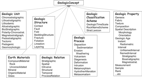
Figure 1. Draft high-level geologic concept hierarchy. |