
Digital Mapping Techniques '02 -- Workshop Proceedings
U.S. Geological Survey Open-File Report 02-370
From Paper to Digital: A Geologic Map's Odyssey
By Stephanie A. O'Meara,1 Tim Connors,2 Trista L. Thornberry,1 Joe D. Gregson,3 Anne R. Poole,4 and Bruce Heise2
1Colorado State University/National Park Service Cooperator
1201 Oak Ridge Drive, Suite 200
Fort Collins, CO 80525
Telephone: (970) 225-3584
e-mail: Stephanie_O'Meara@partner.nps.gov, Tthorn@cnr.colostate.edu
2National Park Service -- Geologic Resources Division
12795 West Alameda Parkway
Lakewood, CO 80228
Telephone: (303) 969-2093
e-mail: Tim_Connors@nps.gov, Bruce_Heise@nps.gov
3National Park Service -- Natural Resources Information Division
1201 Oak Ridge Parkway, Suite 200
Fort Collins, CO 80525
Telephone: (970) 225-3559
e-mail: Joe_Gregson@nps.gov
4National Park Service -- Intermountain Region
Intermountain GIS Support
Bandelier Hall West, Room 203
Albuquerque NM 87131
Telephone: (505) 346-2885, extension 260
e-mail: Anne_Poole@nps.gov
INTRODUCTION
Bedrock and surficial geologic maps and supporting information provide the foundation for studies of ecosystems, Earth history, ground water, geomorphology, soils, and environmental hazards such as fire history, landslide and rockfall potential, etc. Geologic maps describe the underlying physical conditions of many natural systems and are an integral component of the physical science inventories stipulated by the National Park Service (NPS) in its Natural Resources Inventory and Monitoring Guideline. The NPS has identified GIS and digital cartographic products as fundamental resource-management tools. There are few geologists employed at parks; thus, these tools are particularly important to the NPS to aid resource managers in using geologic data for park management decisions.
WHY DIGITAL?
Digital geologic maps have several advantages over paper geologic maps. Digital geologic maps can be used in a digital GIS environment where they can be integrated with other geospatial data to provide analysis of spatial relationships. A GIS provides quick, reproducible, precise analytic results. Digital data are also more easily shared and transferred between users. With digital attribute capability, a digital geologic map becomes a powerful database. The NPS is in the midst of producing other digital data sets for soils, vegetation, species distribution, and hydrology. These themes will be used in conjunction with the digital geologic themes to better promote integrated science in the national parks.
THE ODYSSEY FROM PAPER TO DIGITAL
One of the unresolved issues facing developers of digital geologic maps and data models is how to include map-unit descriptions, supplemental explanatory text (references and map notes), geologic cross sections, and the variety of other printed information that occur on published maps. The overarching development goal of the NPS Inventory and Monitoring Program is to produce digital products that are immediately useful to anyone familiar with their analog counterparts. For geologic maps, this means that the map-unit legend must be sorted and shaded appropriately by geologic age and that all textual, graphical, and other information from the published maps must be available interactively to the user. In short, the digital product must "look and feel" like its published source.
The NPS is developing most digital products in ESRI (Environmental Systems Research Institute) ArcView GIS software. ArcView interfaces effectively with other software running on the Microsoft Windows operating system. Also, integrating a variety of tools, including the NPS GIS Theme Manager, Windows Help software, a Microsoft Visual Basic graphics viewer program, and the ArcView legend editor, has allowed users to display geologic map information in a GIS.
COMPLETING THE ODYSSEY
The text below details the steps in transforming a paper geologic map to a user-friendly digital geologic map and database. First, the paper geologic map is scanned and the resulting image is georeferenced, providing a background for the digitization (capture) of geologic features. In accordance with the NPS Geology-GIS Data Model (O'Meara and others, 2002), the spatial and geologic feature types present (i.e., polygon, line, point, fault, fold, unit, etc.) are captured into appropriate GIS coverages and attributed according to the data model. These data are then incorporated into the NPS GIS Theme Manager that facilitates (in ArcView 3.3) the presentation of the various map coverages along with any Federal Geographic Data Committee (FDGC) metadata and accompanying help files that display map notes, unit descriptions, and other ancillary data from the original paper source map. Any map graphics (e.g., geologic cross sections) are scanned from the original paper map and "hot-linked" to a coverage (e.g., the cross-section line coverage) on the digital geologic map. These data are then posted on the NPS Inventory and Monitoring Program GIS FTP Web site for user access and download.
It All Starts with a Paper Map . . .
An existing traditionally printed map is the starting point in the odyssey (Figure 1).
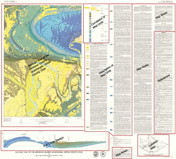
Figure 1. Image of the paper geologic map of Dinosaur Quarry quadrangle. Map components are indicated with diagonal text.
|
Digitizing Geologic Map Features
Using ArcView 3.3 and a georeferenced image of the source map, linear and point geologic features are captured (Figure 2). These digitized features are attributed according to the existing NPS Geology-GIS Data Model coverages.
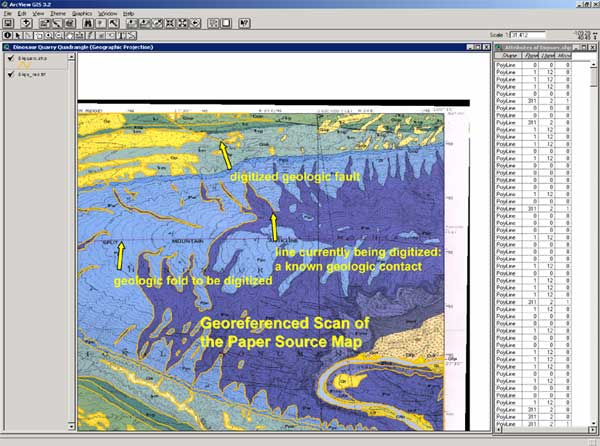
Figure 2. Image showing digitizing of a geologic map in ArcView 3.3 using a georeferenced scan of the source paper geologic map. Attribute table with codes indicates (1) type of line feature (FTYPE): geologic contact, anticlinal fold, normal fault, etc., (2) accuracy of line position/concealment (LTYPE): known or certain, approximated, concealed, etc., (3) whether the line is present in multiple coverages (MCOV; e.g., a contact between different geologic units that is also a fault).
|
Attributing geologic coverages in ArcView 3.3 using the NPS Geology-GIS Data Model
Geologic features are attributed according to the Data Model to preserve all components of the original source map. Figure 3 shows the geologic-units (polygon) area coverage being attributed. Geologic-unit data captured include the geologic-unit symbol (e.g., Ppc), its age relative to other map units, source map ID, and a help file link. Geologic units and contacts, faults, folds, attitude points, mine-related features, cross-section lines, and linear joints are all coverages derived from the Dinosaur Quarry quadrangle map. At present, there are 22 NPS Geology-GIS Data Model coverages.
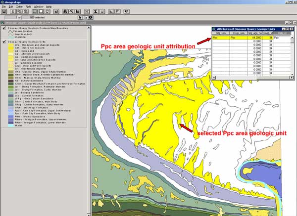
Figure 3. Image showing NPS Geology-GIS Data Model attribution of an area (polygon) geology coverage using ArcView 3.3.
|
Dinosaur Quarry Quadrangle Geologic Map and Cross-Section A-A'
A finished map is displayed in ArcView 3.3 using the NPS GIS Theme Manager (Figure 4), which organizes and presents GIS coverages complete with titles, legend files, and links to metadata, help files, and graphics. An example of such a link is shown in the cross-section graphic (Figure 5).
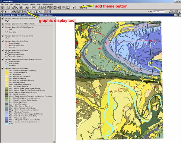
Figure 4. Image showing completed digital geologic GIS data in ArcView 3.3.
|
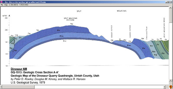
Figure 5. Image showing presentation of geologic cross section A-A' in ArcView 3.3 using the NPS GIS Theme Manager.
|
Dinosaur Quarry Quadrangle Metadata
Using the NPS GIS Theme Manager in ArcView 3.3, a user can display FGDC-compliant metadata related to each geologic coverage (Figure 6).
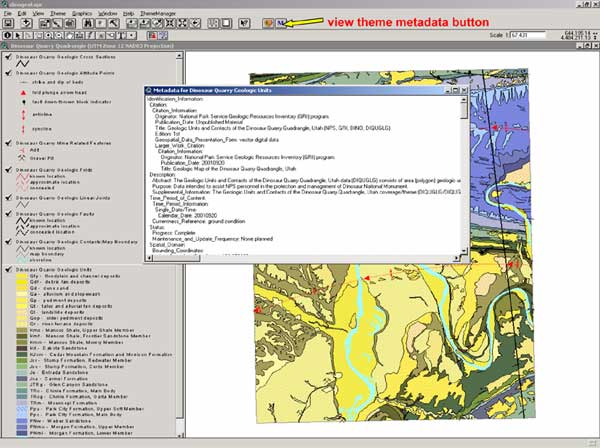
Figure 6. Image showing presentation of GIS data and FGDC metadata in ArcView 3.3 using the NPS GIS Theme Manager.
|
Dinosaur National Monument Geologic Map Help File
Contained within many geologic coverages are links to a geologic-map help file. Using the NPS GIS Theme Manager allows a user to display the help file in an interactive way within ArcView 3.3, complete with keyword searchability (Figure 7). The help file contains map-unit descriptions as well as other information, including reference information about the source maps used to compile the digital geologic map references, map notes, correlation of map units, and other ancillary information shown on the original paper map.
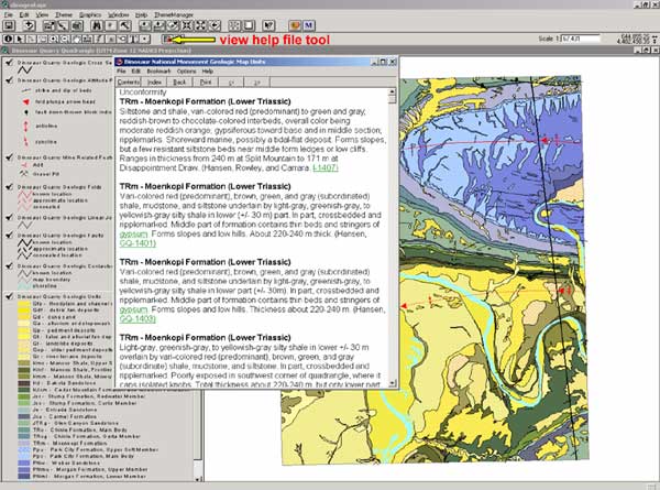
Figure 7. Image showing presentation of a geology help file in ArcView 3.3 using the NPS GIS Theme Manager.
|
National Park Service Inventory and Monitoring GIS FTP Web Site
Digital geologic data and maps produced by the NPS are available online at http://www3.nature.nps.gov/im/gis/ftp/ftparchive.cfm. Data can be searched by park(s) and specified keywords. Data are available in ArcInfo 8.1 "E00" coverages or ArcView 3.3 shape (.SHP) formats and include associated FGDC-compliant metadata, help files, cross-section graphics, ArcView 3.3 (.AVL) legend files, and NPS GIS Theme Manager geology theme lists. The Web site lists the park(s) of interest, data category (e.g., geology), the data set or coverage title, the download file name, the data set or coverage file name, metadata file link, source of the data, and download file size (Figure 8).
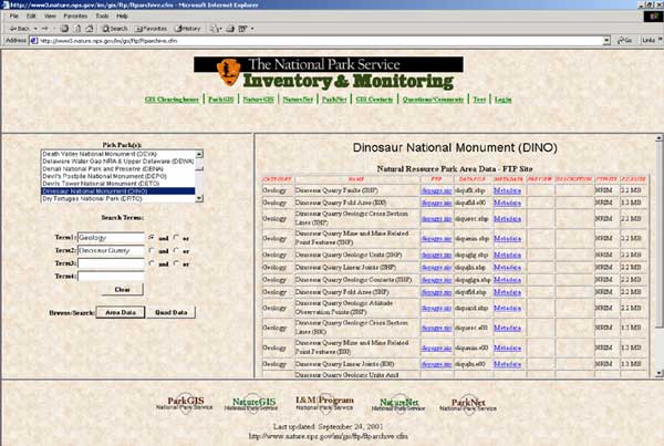
Figure 8. Image showing available geologic GIS data available at the NPS GIS FTP Web site for the Dinosaur Quarry quadrangle map.
|
Geologic GIS data are available at the NPS GIS FTP Web site for the following NPS units:
Arches National Park, Utah (ARCH)
Badlands National Park, South Dakota (BADL)
Bent's Old Fort National Historic Site, Colorado (BEOL)
Black Canyon National Park, Colorado (BLCA)
Bryce Canyon National Park, Utah (BRCA)
Capitol Reef National Park, Utah (CARE)
Colorado National Monument, Colorado (COLM)
Curecanti National Recreation Area, Colorado (CURE)
Dinosaur National Monument, Colorado and Utah (DINO)
Florissant Fossil Beds National Monument, Colorado (FLFO)
Great Sand Dunes National Park, Colorado (GRSA)
Hovenweep National Monument, Colorado and Utah (HOVE)
Mesa Verde National Park, Colorado (MEVE)
Natural Bridges National Monument, Utah (NABR)
Pipe Spring National Monument, Arizona (PISP)
Rocky Mountain National Park, Colorado (ROMO)
Saguaro National Park, Arizona (SAGU)
Timpanogos Cave National Monument, Utah (TICA)
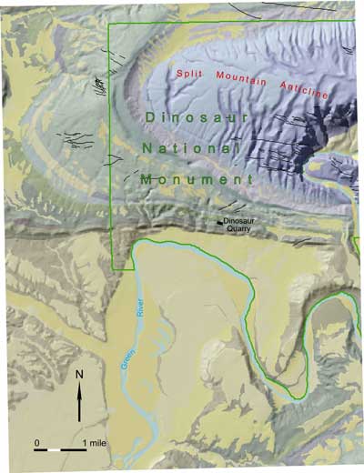
Geology of the Dinosaur Quarry Quadrangle
Figure 9 shows the geology of the Dinosaur Quarry quadrangle with hillshading added.
|
|
|
|
Figure 9. Image showing the geology of the Dinosaur Quarry (part of Dinosaur National Monument) quadrangle draped over a hillshade to depict the interrelationships of geology and geomorphology.
|
REFERENCE
O'Meara, S.A., Gregson, J.D., and Poole, A.R., 2002, National Park Service Geology-GIS Data Model, http://www1.nature.nps.gov/im/gis/GeologyGISDataModel.htm.
RETURN TO Contents
National Cooperative Geologic
Mapping Program | Geologic Division |
Open-File Reports
U.S. Department of the Interior, U.S. Geological Survey
URL: https://pubsdata.usgs.gov/pubs/of/2002/of02-370/omeara.html
Maintained by David R. Soller
Last modified: 19:15:44 Wed 07 Dec 2016
Privacy statement | General disclaimer | Accessibility