
Digital Mapping Techniques '02 -- Workshop Proceedings
U.S. Geological Survey Open-File Report 02-370
Field Description of the Scientific and Locational Accuracy of Geologic Features (a Part of the Draft FGDC Geologic Map Symbolization Standard)
By David R. Soller1, Taryn A. Lindquist,2 and Jonathan C. Matti3
1U.S. Geological Survey
908 National Center
Reston, VA 20192
Telephone: (703) 648-6907
Fax: (703) 648-6937
e-mail: drsoller@usgs.gov
2U.S. Geological Survey
Menlo Park, CA 94025
e-mail: tlnquist@usgs.gov
3U.S. Geological Survey
Tucson, AZ 85719
e-mail: jmatti@usgs.gov
BACKGROUND
A national standard for the digital cartographic representation of geologic map features is being prepared for approval by the Federal Geographic Data Committee's (FDGC) Geologic Data Subcommittee. Anticipated for approval in 2003, this standard will be applicable to all geologic map information and geologic map databases published by the Federal Government and its Federally funded contractors and collaborators. Nonfederal agencies and private firms that produce geologic map information also are urged to adopt the standard. When approved, the standard will be available at http://ncgmp.usgs.gov/fgdc_gds/; at present, background information and the draft standard are found there; the subject of this paper is new material that is not found in that draft.
The standard is intended to support the Nation's producers and users of geologic map information by providing line symbols, point symbols, and colors and patterns that can be used to portray the various features on geologic maps. The objective of the standard is to aid in the production of geologic maps and related products as well as to help provide geologic maps and products that are more consistent in their appearance and their underlying database content. The imperative for the clear communication of geologic map information to a diverse audience was outlined early in the history of the U.S. Geological Survey (USGS) by then-Director John Wesley Powell, who stated that "the maps are designed not so much for the specialist as for the people, who justly look to the official geologist for a classification, nomenclature, and system of convention so simple and expressive as to render his work immediately available alike to the theoretic physicist or astronomer, the practical engineer or miner, and the skilled agriculturist or artisan" (Powell, 1888, p. 229).
The consistent, unambiguous expression of geologic map information is even more critical now because such information increasingly is compiled, stored, manipulated, and exchanged in digital files and geospatial databases. In these files, the cartographic representation of each feature on a geologic map must have a unique and explicit meaning, which also must be compatible with the feature's attributes in the geologic map database. To that end, the preparers of the standard reviewed existing formal and informal USGS geologic map symbolization standards and adapted them for implementation with modern digital mapmaking systems and geospatial databases.
This standard is not intended to be used inflexibly or in a manner that will unduly restrict a geologist's ability to communicate the observations and interpretations gained from geologic mapping. On the contrary, the standard recognizes that, in certain situations, an existing symbol or its use might need to be modified to fit a particular geologic situation or setting. Likewise, the standard recognizes that a new symbol or set of symbols may need to be created to more fully express local geologic conditions or to keep pace with evolving geologic mapping concepts and practices. Accordingly, such new or modified symbols, if found to be of wide applicability, will be incorporated into the standard through planned, periodic revisions.
The standard will contain updated, precise guidance on the selection of symbology for geologic features for which scientific interpretation is uncertain and/or for which locational accuracy is diminished by poor exposure, an inadequate base map, or other factors. At the DMT '02 workshop, the section of the standard addressing these issues was introduced and discussed, and guidance and suggested revisions were sought. From that discussion and from comments by the newly formed Map Standards Committee, 1 that section of the draft FGDC standard was slightly revised. In this paper we excerpt a preliminary version of that section to expose the issues to the broader geoscience community.
ACKNOWLEDGMENTS
The draft FGDC standard owes its existence to the well-established history and traditions of geologic map cartography by the USGS. In particular, the editors and compilers of this standard wish to thank the many cartographers, editors, and geologists who contributed to the informal USGS "Technical Cartographic Standards" volume. We especially wish to thank the many members of the USGS Geologic Discipline's Western Publications Group and the Map Standards Committee, who have made substantial contributions to the design and preparation of this standard. We also thank the DMT '02 attendees for their helpful comments, and Nancy Stamm (USGS) for suggestions on the document's concepts and organization and for creating the figures.
SCIENTIFIC CONFIDENCE AND LOCATIONAL ACCURACY OF GEOLOGIC MAP FEATURES
An important concept in geologic mapping is the geologist's level of confidence in the interpretation of features observed in the field. Many factors can adversely affect a geologist's level of confidence when mapping; in the field, interpretation of a feature may be in question, as indicated by the following examples:
- A planar feature is well exposed in outcrop, but it is not easily identifiable as either a contact or a fault.
- A contact is clearly exposed in a roadcut, but its location cannot be followed away from that roadcut.
- A fault is obscured by vegetation, and so both its location and its sense of offset cannot be definitively determined.
- A fault's location is completely concealed beneath valley fill.
As these examples show, uncertainties can exist in either the scientific interpretation or the mapped location of a feature, or in both. Therefore, not only is it important to communicate to the map user the level of confidence in each geologic map feature, but also which type of uncertainty--scientific and/or locational--may be associated with that feature.
Traditionally, geologic maps have used a system of solid, dashed, dotted, or queried line-symbol styles (for example, Ridgway, 1920, plate 2) to show levels of locational accuracy of planar and linear geologic features observed in the field. This convention followed USGS Director Powell's 1888 policy that stipulated: ". . . fault lines (particularly when they are formation boundaries) shall be indicated when actually traced by somewhat heavy full lines in black; and when not actually traced, by similar broken lines" (Powell, 1890, p. 76). More guidance was provided in 1956 by USGS Chief Geologist W.H. Bradley, who, in a memorandum to USGS personnel regarding geologic map standards, stated, "The accuracy of location of faults and contacts should be shown by appropriate symbols . . . . Solid lines should be used to indicate accurate locations of features that are geologically identifiable within the plottable limits of the map . . . . Features that are only approximately located should be shown by long dashed lines; those that are indefinite or inferred, by short dashed lines; and those that are concealed, by dotted lines" (W.H. Bradley, written commun., 1956). To further encourage the use of such symbology, Bradley added, "The use of many dashed contacts or faults on a map is not to be construed as a detraction from the quality of the map, and for many maps, it may be undesirable or impossible to achieve sufficiently accurate locations to permit use of solid lines. The quality of the map is not impaired so long as the reader can interpret the accuracy of location."
In conjunction with these traditional line symbol styles, geologists have used terms such as "known," "probable," "certain," "uncertain," "accurately located," "approximately located," "inferred," "projected," "concealed," and "queried" to express the various levels of confidence of planar and linear geologic features. However, these terms and their associated line-symbol styles have not been used consistently from region to region or from map to map, in part owing to different geologic conditions, mapper's preferences, and available time, funding, and purpose for the mapping. For example, some distinct inconsistencies in the meaning of a solid-line geologic contact have persisted (Figure 1). It is not always clear whether these terms reflect uncertainty in a feature's scientific interpretation, its mapped location, or both. As noted above, this standard endeavors to address these inconsistencies through guidance and standard terminology.
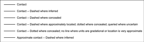
Figure 1. An informal perusal of map-unit explanations on geologic maps published in the past 30 years reveals widely varying meaning for a solid-line geologic contact, depending on the geologic conditions; mapper's preferences; and available time, funding, and purpose for the mapping.
|
Scientific Confidence
Scientific confidence expresses the geologist's level of certainty regarding the nature, origin, geometry, identity, and even the existence of a geologic feature. The characteristics of the geologic materials and structures, the number of outcrops, and the availability of subsurface or geophysical data directly affect the level of scientific confidence in any area. Experience and resources available to the geologist also affect scientific confidence. These fundamental characteristics of geologic features can be grouped into two distinct but related concepts: identity and existence.
Identity expresses whether or not the observations and data support the stated nature, origin, or geometry of a mapped geologic feature (for example, a contact versus a fault, or a normal fault versus a thrust fault). On the geologic map, the feature is identified and described using standard symbology; uncertainty in its identity may be included in the explanation of the symbol or the description of the map unit. In the geologic map database, the attribute describing the confidence in a feature's identity is specified as either certain or questionable.
Existence expresses whether or not the observations and data support the continuity or existence of a concealed geologic feature (for example, a mapped fault versus a postulated subsurface fault). On the geologic map, the feature is identified and described using standard symbology; uncertainty in its continuity or existence may be included in the explanation of the symbol or the description of the map unit. In the geologic map database, the attribute describing the confidence in a feature's existence is specified as either certain or questionable.
Levels of Scientific Confidence
A geologic map must indicate the level of scientific confidence associated with each mapped feature (both its identity and its existence). This information also should be specified as attributes in the geologic map database, contained in two attribute fields: identity (permissible values = certain; questionable), and existence (permissible values = certain; questionable).
For some types of geologic map features, the level of scientific confidence also is communicated cartographically. To facilitate the cartographic communication of the two concepts of identity and existence, this standard sets forth the following new terminology to express clearly yet concisely the levels of scientific confidence of the features that are shown on a geologic map:
- Identity and existence certain. The identity and the existence of a feature can be determined using relevant observations and scientific judgment; therefore, one can be reasonably confident in the scientific credibility of this interpretation. These criteria are met, for example, when a geologist reasons, "I am certain that the planar feature I see in this outcrop is a fault." This is the default condition for all geologic map features unless otherwise stated on the geologic map or in the geologic map database.
- Identity or existence questionable. Either the identity or the existence of a feature cannot be determined using relevant observations and scientific judgment; therefore, one cannot be reasonably confident in the scientific credibility of this interpretation. These criteria are met, for example, when a geologist reasons, "I can see some kind of planar feature in this outcrop, but I cannot be certain whether it is a contact or a fault," or "My interpretation requires that a thrust fault be present to account for incongruities in the stratigraphy of these rocks, but I can't be certain because I haven't yet seen one here."
This new terminology is intended to be used for choosing a particular style of symbol to represent a feature on a geologic map (for example, Figure 2 shows the symbolization for geologic contacts), as well as for describing that feature on the map. If a feature is symbolized or described as "identity or existence questionable," the map user should consult the geologic map database for more complete information.
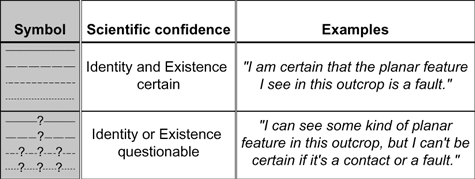
Figure 2. Symbology and new standard terminology to express the level of scientific confidence in the identity and existence of a geologic feature.
|
Locational Accuracy
Locational accuracy involves the interplay between two distinct but related factors: the locatability of a feature in the field, and its positioning on the map.
Locatability expresses whether a geologist can clearly observe a feature in the field, as indicated by the following examples:
- A planar or linear feature is observable in several outcrops along its trace.
- A planar or linear feature is observable in only a few outcrops along its trace, but its physical characteristics permit locating it between outcrops by indirect methods.
- A planar or linear feature is not defined by a distinctive physical trace and so is not observable beneath either vegetation, a thin veneer of unmapped geologic material (colluvium, eolian deposits, or residual soil), or manmade features; therefore its location must be inferred by indirect means.
- A planar or linear feature is not observable because it is concealed by an overlying geologic map unit, although it may be observable nearby (for example, a thrust fault is visible on both sides of a glacial valley, but its location within the valley is concealed by ice), and so its location must be projected beneath the overlying map unit.
In the explanation of geologic map symbols and in the geologic map database, the attribute describing the confidence in a feature's locatability is specified as either observable, inferred, or concealed (Figure 3).
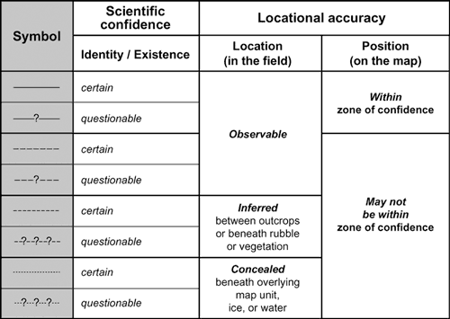
Figure 3. Diagram showing relationship between map symbol and scientific confidence and locational accuracy terminology.
|
Positioning expresses the relative degree of accuracy with which a geologic feature is plotted on the base map. Commonly, a feature can be accurately plotted on the map because the base-map information is accurate, detailed, and distinctive. However, in some field situations, a feature cannot be confidently plotted on the map because the topographic, drainage, or cultural information on the base map is insufficiently detailed for the feature to be accurately located relative to features on the map, as indicated by the following examples:
- A feature is observable, but its position on the map cannot be placed accurately because topographic contours, drainage lines, or cultural information on the base map are insufficiently detailed for the feature to be confidently located relative to the various base-map features (for example, a contact is observable in outcrop, but its location in relatively featureless terrain prevents its position from being plotted accurately on the base map).
- A feature is observable, and its geographic coordinates can be determined in the field using a global positioning system (GPS) device or in the laboratory using a georeferenced aerial photograph stereopair; however, the geographic relation between these coordinates and the topographic or cultural setting shown on the base map is not compatible (for example, a feature was mapped on a hillside, but the GPS-derived coordinates, when plotted on the base map, place its position in a valley bottom).
In such situations, either a feature can be plotted relative to the indistinct or incompatible base-map features, or the locations of topographic contours or other base-map features can be adjusted. (The latter approach is not encouraged unless it is done systematically and is well-documented.) In either case, the inherent uncertainty in a feature's positioning must be conveyed cartographically and recorded in the geologic map database, as explained below.
Specifying the Positional Accuracy
Information about the locational accuracy of mapped features is important to all disciplines, even those in which mapped features commonly are directly observable and can be positioned with a significant degree of accuracy (for example, roads or utilities). It is especially critical in the natural sciences because many mapped features are either interpretive or not directly observable. To specify the locational accuracy of a mapped feature, the geologic mapper must weigh three factors: (1) the nature of the feature and its degree of exposure (for example, a gradational or sharp geologic contact that is poorly or well exposed along a hillside), (2) the quality of the base map (for example, whether the map shows cultural and topographic features positioned accurately according to the geologist's reckoning, triangulation, GPS readings, etc.), and (3) the geologist's confidence in accurately positioning the geologic feature on the base map. Together, these factors determine the mapper's confidence in the locational accuracy of each feature positioned on the base map. The first factor is characterized above as "locatability," and terminology is given for describing it. This section addresses the aspect of locational accuracy involved in positioning an identifiable and observable feature on the base map.
The process of locating a feature in the field and then positioning it on the base map is complex, and the locational accuracy of the mapped feature is not easily described and quantified. In the USGS, stringent policies for the accuracy with which a well-located feature can be positioned on the base map have been put forth in the past. For example, Chief Geologist W.H. Bradley's 1956 memorandum to the staff advocated a geologic map accuracy standard based on the United States National Map Accuracy Standards (NMAS) for topographic and other types of base maps. The geologic map adaptation of the NMAS stipulated that "features that . . . can be located from exposures or other evidence [should be positioned] within 1/25 inch [on the map] of their true map position" (W.H. Bradley, written commun., 1956; U.S. Geological Survey, 1995, Part 1, p. 1.0-4). These earlier efforts to quantify the locational accuracy of geologic features were not widely adopted by the geoscience community, likely in part because of (1) the difficulty in translating to geologic mapping a concept designed for topographic and other types of base maps, and (2) the impracticality of requiring that all geologic map information meet the same accuracy criteria uniformly across the Nation, in all types of geologic and topographic settings, and (3) the need to convert ground distance to publication-scale cartographic units before determining whether a feature can be plotted accurately on a base map. In contrast, the standard described in this document advocates a more flexible and conceptually simpler approach in which the accuracy criteria can be defined for each project so that the expressed positional accuracy reflects the character of the geologic setting and other factors.
When a feature is drawn or digitized onto the base map, the geologic mapper commonly has some level of confidence regarding whether the feature has been accurately positioned, on the basis of the three factors noted above. This confidence can be expressed by the likelihood that the feature actually lies within a certain distance from the location where it is positioned on the base map. This distance, extending outward from a feature's position on the map, is designated as the zone of confidence, and it characterizes the feature's positional accuracy as follows:
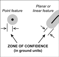
- For planar and linear geologic features, the zone of confidence borders the feature along both sides, forming what is described in GIS terminology as a buffer zone; it is specified as the distance in ground units (for example, in feet or meters) from the feature to the edge of the buffer zone (Figure 4). For geologic point features, the zone of confidence is concentric around the feature, forming a circle, the specified distance being the radius of that circle. The numerical value of the zone of confidence should be provided on the geologic map (in the symbol explanation and the map-unit description) and as an attribute in the geologic map database.
- For each geologic feature on the map and in the database, the likelihood that it actually lies within the zone of confidence should be indicated (see Figure 3). On the geologic map, this likelihood is conveyed cartographically (for example, an observable and accurately located contact is shown as a solid line; an inferred contact is shown as a dashed line). In the geologic map database, this is conveyed by an attribute specifying that the feature's position is either "within zone of confidence" or "may not be within zone of confidence." Note that the standard does not stipulate that a feature for which positioning is specified as "may not be within zone of confidence" must necessarily be located outside the zone of confidence, but simply that it may be.
|
|
Figure 4. Diagram showing the zone of confidence for point, planar, and linear features.
|
For any geologic map or mapped area, the numerical value of the zone of confidence will depend on a number of factors: the area's geology, landscape terrain, vegetation cover, and/or cultural features; the scale of mapping; the quality and nature of the base map used; and/or a particular project's allotted field-mapping time or other logistical constraints. Because the standard recognizes that the factors affecting the value of the zone of confidence will vary from region to region (and from map to map), and because different agencies have differing mapping needs and mandates, a universal value for the zone of confidence is not established in the standard. Instead, this standard advocates that the responsibility for setting the value of the zone of confidence for a particular geologic map or mapped area lies with each geoscience organization and each mapping geologist.
For many geologic maps or mapped areas, especially those that are defined by latitude and longitude (for example, quadrangle maps) or political boundaries (for example, state or county maps), one map may contain areas of vastly contrasting geology, topography, vegetation cover, and/or societal infrastructure. For example, a geologic map may include a mountain range underlain by sedimentary rocks and a broad alluvial valley. Clear distinction among the various sedimentary rocks as well as their high relief may provide the geologist with a significantly higher level of confidence in the position of contacts than in the adjacent valley, where few topographic landmarks or contours exist and where geologic contacts are gradational and/or obscured by vegetation and soil cover. In areas as diverse as these, the levels of confidence in positional accuracy will be different, and so the geologist has the following choices: (1) specify different values of the zone of confidence for the two areas, thereby permitting more differentiation of features within each area, or (2) express the differences in confidence solely by differences in line symbology (for example, use mostly solid lines in the mountain range and mostly dotted lines in the valley). The choice might depend on the magnitude of the difference between the areas, or on the geologist's confidence in the positional accuracy of features across the map area. Map compilations represent another example for which different positional accuracy criteria can exist within a single map; a map compilation may be composed of several source maps or mapped areas, each of which may have had a different value specified for the zone of confidence (or perhaps no value had been specified). The geologist may choose to preserve in the map compilation these various zones of confidence.
In the geologic map database, variations in the value of the zone of confidence can be readily accommodated because each feature is assigned (as an attribute in the database) the value of the zone of confidence that has been specified for a particular area. On the geologic map, the areas that have different zone of confidence values should be shown in an index map.
Levels of Locational Accuracy
A geologic map must communicate to the map user the level of locational accuracy associated with each mapped feature (its locatability in the field and its positioning on the base map) by specifying this information as attributes in the geologic map database. The information is contained in the following three attribute fields: (1) locatability (observable, inferred, or concealed), (2) the numerical value of the zone of confidence (for example, 5 meters), and (3) the likelihood that the feature actually occurs within the zone of confidence (within zone of confidence, may not be within zone of confidence). In addition, the numerical value of the zone of confidence should be indicated on the geologic map, either in a general statement (if one value applies to the entire geologic map) or shown in an index map (if different values apply to different mapped areas); likewise, if a zone of confidence was not used during mapping or map compilation, this should be indicated.
For some types of geologic map features, the level of locational accuracy also is communicated cartographically by using specialized symbology. To facilitate the cartographic communication of the two concepts of locatability and positioning, the standard sets forth the following revised terminology to express clearly yet concisely the levels of locational accuracy of the features that are shown on a geologic map:
- Location accurate. A feature is observable, and its plotted position on the map is within the declared zone of confidence. These criteria are met, for example, when a geologist reasons, "I can clearly see this contact in outcrop, and I can accurately plot its position on the map." This is the default condition for all geologic map features unless otherwise stated on the geologic map or in the geologic map database.
- Location approximate. A feature is observable, but its plotted position on the map may not be within the declared zone of confidence. These criteria are met, for example, when a geologist reasons, "I can see this contact in outcrop, but I can't tell exactly where it is located because I am surrounded by trees," or "I can see this contact in outcrop, but the poor quality of my base map prohibits me from accurately plotting its position," or "I can see that the width of the gradational contact between these two map units exceeds my value of the zone of confidence, and so, although my base map is of high quality, my confidence in the accuracy of its plotted position is not high."
- Location inferred. A feature is not directly observable between outcrops or beneath rubble or vegetation, so its location must be inferred by indirect means; by definition, its plotted position on the map may not be within the declared zone of confidence. These criteria are met, for example, when a geologist reasons, "I can see by the change in debris materials visible around these gopher holes that a contact runs through here, but I can't locate it very precisely."
- Location concealed. A feature is not observable because it is completely concealed beneath an overlying map unit or body of water or ice (although it may be observable nearby); by definition, its plotted position on the map may not be within the declared zone of confidence. These criteria are met, for example, when a geologist reasons, "I can see that a contact is present on both sides of this lake, but I can't tell where it is located beneath the water."
This new terminology is intended for choosing a particular style of symbol to represent a feature on a geologic map (for example, Figure 5 shows the symbolization for geologic contacts) as well as for describing that feature on the map. This terminology also is intended to be used in the attributes of symbols in the geologic map database.
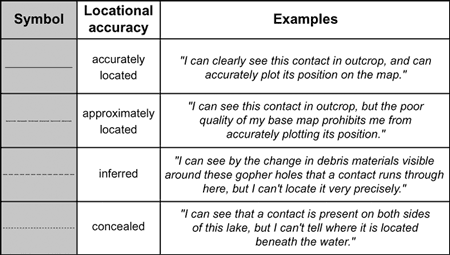
Figure 5. Symbology and new standard terminology to express the locational accuracy of a geologic feature.
|
SUMMARY
In part because geologic map information is increasingly used in a digital (GIS) environment in concert with environmental and cultural information, precise terminology is essential for describing the scientific confidence and locational accuracy of geologic features. This section of the pending FGDC standard for geologic map symbolization provides a standard terminology, but retains some flexibility for describing locational accuracy. The standard is intended for periodic review and revision; therefore, the authors welcome your comments and guidance on the issues presented in this paper.
REFERENCES
Powell, J.W., 1888, Methods of geologic cartography in use by the United States Geological Survey, in Congrès Géologique International, Compte Rendu de la 3me Session, Berlin, 1885: A.W. Schade's Buchdruckerei, Berlin, p. 221-240.
_______ 1890, Tenth Annual Report of the United States Geological Survey 1888-'89, Part I--Geology: Washington, D.C., U.S. Government Printing Office, 774 p.
Ridgway, J.L., 1920, The preparation of illustrations for reports of the United States Geological Survey: Washington, D.C., U.S. Government Printing Office, 101 p.
U.S. Geological Survey, 1995, Cartographic and digital standard for geologic map information: U.S. Geological Survey Open-File Report 95-525, 257 p.
RETURN TO Contents
National Cooperative Geologic
Mapping Program | Geologic Division |
Open-File Reports
U.S. Department of the Interior, U.S. Geological Survey
URL: https://pubsdata.usgs.gov/pubs/of/2002/of02-370/soller1.html
Maintained by David R. Soller
Last modified: 19:15:46 Wed 07 Dec 2016
Privacy statement | General disclaimer | Accessibility