 Introduction Introduction
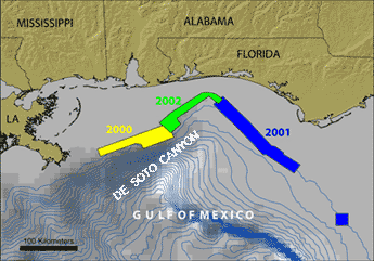
The mid to outer continental shelf off Mississippi-Alabama and off northwest Florida were the focus of U.S. Geological Survey (USGS) multibeam echosounder (MBES) mapping cruises in 2000 and 2001, respectively. These areas were mapped to investigate the extent of "deep-water reefs" first suggested by Ludwig and Walton (1957). The reefs off Mississippi and Alabama were initially described in water depths of 60 to 120 m (Ludwig and Walton, 1957) but the 2000 mapping found reef and hardgrounds to be much more extensive than previously thought (Gardner et al., 2001). The persistent trend of reef-like features along the outer shelf of Mississippi-Alabama suggested the trend might continue along the northwest Florida mid and outer shelf so a MBES-mapping effort was mounted in 2001 to test this suggestion. It is critical to determine the accurate location, geomorphology, and types of the ridges and reefs that occur in this region to understand the Quaternary history of the area and to assess their importance as benthic habitats for fisheries.
The area known as the "Head of De Soto Canyon" is the large unmapped region between the 2000 and 2001 mapped areas. It was unknown whether the reefs of the Mississippi-Alabama shelf continue eastward into the head of De Soto Canyon and connect with the ridges and reefs mapped on the northwest Florida outer shelf. The existence of carbonate-cemented Quaternary to Holocene sandstones along the western wall of the head of De Soto Canyon (Shipp and Hopkins, 1978; Benson et al., 1997; W.W. Schroeder, personal commun., 2002) is of interest because of the potential benthic habitats they may represent. In the summer of 2002, the USGS, in cooperation with Minerals Management Service (MMS), the University of New Hampshire, and the University of New Brunswick, conducted a MBES survey of the Head of De Soto Canyon Region connecting the 2000 and 2001 mapped regions.
|
First posted January 21, 2003
Part or all of this report is presented in Portable Document Format (PDF). For best results viewing and printing PDF documents, it is recommended that you download the documents to your computer and open them with Adobe Reader. PDF documents opened from your browser may not display or print as intended. Download the latest version of Adobe Reader, free of charge.
|

