USGS - science for a changing world

Open-File Report 03-120

Bathymetry and selected perspective views of 6 reef and coastal areas in Northern Lake Michigan.

Hog Island Reef
 

Home
Intro
Map Views
  Boulder Reef
  Gull Island Reef
  Little Traverse Bay
  Trout and High Island Reefs
  Hog Island Reef
  Dahlia Shoals
Data
  XYZ
  Grid
Posters

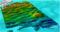
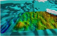
Click on the thumbnail images to view Hog Island Reef perspective images at full size, or use the Location Map at the bottom of the page to navigate to perspective views of other locations.

Hog Island Reef map

Figure 6.1 - Shaded relief map of area southeast of Hog Island including Hog Island Reef (shoal at lower right). This mapped area is marked by strong northwest-southeast ridges and lineations about a meter high and a few meters wide. These lineations are more pronounced but have a similar orientation to those to the west in the Trout Island map (Fig.5.1). An indistinct northeast southwest lineation is also present, especially in the northeastern quadrant of the image(Fig, 6.3) draped over this morphology are patches of smoother relief (sand?) which forms north-south bedforms. Hog Island reef itself does not seem to have obvious relation to either morphologic feature. Underwater observations (Somers, 1968) report flat lying outcrops of Limestones at Hog Island Reef. (See full-size JPEG--511 kb)

Thumbnails

Oblique looking west at Hog Island Figure 6.2 - Oblique perspective looking northeast at Hog Island Reef area. North-south bedforms are associated with patches of sand(?) aligned east-west. The fine and linearly continuous morphology of glacial or bedrock outcrop underlies both the bedform and sand patches. Distance across the foreground of this perspective is 4.7 km. (JPEG 300 kb)
Oblique perspective looking northeast at Hog Island Reef Figure 6.3 - Oblique perspective looking west at Hog Island Reef area (reefs in left foreground). The pronounced lineations die out to the right and appear buried by a coarse morphology that looks similar to the boulder and cobble areas seen at Boulder and Gull Island Reefs. Distance across the foreground of this perspective is 6.7 km. (JPEG 300 kb)

Location Map
Click on the boxes within the Location Map below to view the mapview and perspective images of those locations.

location map with link to detailed reefs Link to Trout and High Island shoals Link to Gull Island Reef link to Hog Island Shoals Link to Dahlia Shoals Link to Little Traverse Bay Link to Boulder Reef


Accessibility FOIA Privacy Policies and Notices

Take Pride in America logo USA.gov logo U.S. Department of the Interior | U.S. Geological Survey
URL: http://pubsdata.usgs.gov/pubs/of/2003/0120/gl-Hog.html
Page Contact Information: GS Pubs Web Contact
Page Last Modified: Wednesday, 02-Apr-2014 15:34:20 EDT