|
 |
| U.S. Geological Survey
Open-File Report 03-001 |
|
|
FOLGER75: Bottom Sediments -- Cape Ann to Casco Bay
|
Metadata also available as: FAQ - TEXT
Metadata:
- Identification_Information:
-
- Citation:
-
- Citation_Information:
-
- Originator: Lawrece J. Poppe
- Publication_Date: 2003
- Title: FOLGER75: Bottom Sediments -- Cape Ann to Casco Bay
- Edition: 1.0
- Geospatial_Data_Presentation_Form: vector digital data
- Series_Information:
- Publication_Information:
-
- Publication_Place: Woods Hole Field Center, Woods Hole, MA
- Publisher: U. S. Geological Survey, Coastal and Marine Geology Program
- Online_Linkage:
-
<http://pubs.usgs.gov/of/2003/of03-001/data/seddata/folger75/folger75.zip>
- Online_Linkage:
-
<http://pubs.usgs.gov/of/2003/of03-001/data/seddata/folger75/folger75.zip>
- Larger_Work_Citation:
-
- Citation_Information:
-
- Originator: L.J. Poppe
- Originator: V.F. Paskevich
- Originator: S.J. Williams
- Originator: M.E. Hastings
- Originator: J.T. Kelley
- Originator: D.F. Belknap
- Originator: L.G. Ward
- Originator: D.M. FitzGerald
- Originator: P.F. Larsen
- Publication_Date: 2003
- Title:
-
Surficial Sediment Data from the Gulf of Maine, Georges Bank, and vicinity: a GIS Compilation
- Edition: 1.0
- Series_Information:
-
- Series_Name: Open-File Report
- Issue_Identification: 03-001
- Publication_Information:
-
- Publication_Place: Woods Hole Field Center, Woods Hole, MA
- Publisher: U. S. Geological Survey, Coastal and Marine Geology Program
- Other_Citation_Details:
-
Data is released via CD-ROM media. This digital publication may also be available via the web at pubs.usgs.gov
- Online_Linkage: <http://pubs.usgs.gov/of/2003/of03-001>
- Online_Linkage: <http://woodshole.er.usgs.gov/openfile/of03-001>
- Description:
-
- Abstract:
-
The reconnaissance maps upon which this data set is based show the areal distribution of the major bottom sediment types covering the sea floor off eastern New England between Cape Ann and Casco Bay. The maps were intended as a guide to the future mapping of gravel, sand, silt, and clay, and because these sediments reflect the hydraulic conditions, they are also helpful for deducing the important sediment transport mechanisms.
- Purpose:
-
The purpose of this data layer is to release a digital version of the textural descriptions published by Folger et al (1975).
- Time_Period_of_Content:
-
- Time_Period_Information:
-
- Single_Date/Time:
-
- Calendar_Date: 1975
- Currentness_Reference: publication date
- Status:
-
- Progress: Complete
- Maintenance_and_Update_Frequency: None planned
- Spatial_Domain:
-
- Bounding_Coordinates:
-
- West_Bounding_Coordinate: -70.799200
- East_Bounding_Coordinate: -70.000000
- North_Bounding_Coordinate: 43.803300
- South_Bounding_Coordinate: 42.833300
- Keywords:
-
- Theme:
-
- Theme_Keyword_Thesaurus: General
- Theme_Keyword: U.S. Geological Survey
- Theme_Keyword: USGS
- Theme_Keyword: Coastal and Marine Geology Program
- Theme_Keyword: CMGP
- Theme_Keyword: Woods Hole Field Center
- Theme_Keyword: sediments
- Theme_Keyword: texture
- Theme_Keyword: grabs
- Theme_Keyword: sand
- Theme_Keyword: gravel
- Theme_Keyword: silt
- Theme_Keyword: clay
- Theme_Keyword: grain size
- Theme_Keyword: Open-File Report 03-001
- Theme_Keyword: surficial classification
- Theme_Keyword: sediment classification
- Theme_Keyword: ArcView shapefile
- Theme_Keyword: points
- Theme_Keyword: Geographic Information System
- Theme_Keyword: GIS
- Theme_Keyword: bottom sediments
- Place:
-
- Place_Keyword_Thesaurus: General
- Place_Keyword: U.S. East Coast
- Place_Keyword: Atlantic
- Place_Keyword: New England
- Place_Keyword: continental shelf
- Place_Keyword: Cape Ann
- Place_Keyword: Casco Bay
- Place_Keyword: Massachusetts
- Place_Keyword: New Hampshire
- Place_Keyword: Maine
- Access_Constraints: None
- Use_Constraints: None
- Point_of_Contact:
-
- Contact_Information:
-
- Contact_Person_Primary:
-
- Contact_Person: Lawrence J. Poppe
- Contact_Organization: U.S. Geological Survey
- Contact_Position: Geologist
- Contact_Address:
-
- Address_Type: mailing address
- Address: 384 Woods Hole Road
- City: Woods Hole
- State_or_Province: MA
- Postal_Code: 02543-1598
- Country: USA
- Contact_Voice_Telephone: 508-548-8700 x2314
- Contact_Facsimile_Telephone: 508-457-2310
- Contact_Electronic_Mail_Address: lpoppe@usgs.gov
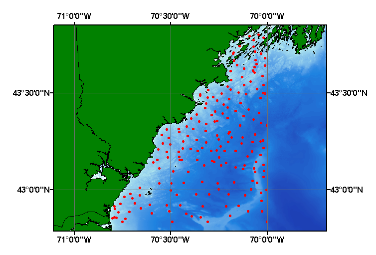
- Browse_Graphic:
-
- Browse_Graphic_File_Name: folger75.gif
- Browse_Graphic_File_Description:
-
Image map showing extent and distribution of data layer coverage.
- Browse_Graphic_File_Type: GIF
- Data_Set_Credit:
-
Please review the cross reference information for the original data set credit to Folger et al. (1975), and Larry Poppe for entering the data from the source report and creating the ArcView shapefile.
- Native_Data_Set_Environment:
-
Microsoft Windows 2000 Version 5.1 (Build 2600) ; ESRI ArcCatalog 8.2.0.700
- Cross_Reference:
-
- Citation_Information:
-
- Originator: D.W. Folger
- Originator: C.J. O'Hara
- Originator: J.M. Robb
- Publication_Date: 1975
- Title:
-
Maps Showing Bottom Sediments on the Continental Shelf of the Northeastern United States--Cape Ann, Massachusetts to Casco Bay, Maine
- Edition: 1.0
- Series_Information:
-
- Series_Name: U.S. Geological Survey Miscellaneous Investigations Series Map
- Issue_Identification: Map I-839, 2 sheets, scale1:125,000
- Data_Quality_Information:
-
- Attribute_Accuracy:
-
- Attribute_Accuracy_Report:
-
All attributes were entered and checked by the compilers in a consistent manner.
- Logical_Consistency_Report:
-
No additional checks for topological consistency were performed on this data.
- Completeness_Report: Sample locations and positions are provided for 187 stations.
- Positional_Accuracy:
-
- Horizontal_Positional_Accuracy:
-
- Horizontal_Positional_Accuracy_Report:
-
No navigational methods are provided in the original publication (most samples were navigated with Loran A, but data came from several sources). Horizontal accuracy is unknown.
- Lineage:
-
- Source_Information:
-
- Source_Citation:
-
- Citation_Information:
-
- Originator: D.W. Folger
- Originator: C.J. O'Hara
- Originator: J.M. Robb
- Publication_Date: 1975
- Title:
-
Maps Showing Bottom Sediments on the Continental Shelf of the Northeastern United States--Cape Ann, Massachusetts to Casco Bay, Maine
- Edition: 1.0
- Series_Information:
-
- Series_Name: U.S. Geological Survey Miscellaneous Investigations Series Map
- Issue_Identification: Map I-839, 2 sheets, scale 125,000
- Publication_Information:
-
- Publication_Place: Washington, DC
- Publisher: U.S. Geological Survey
- Type_of_Source_Media: paper
- Source_Time_Period_of_Content:
-
- Time_Period_Information:
-
- Single_Date/Time:
-
- Calendar_Date: 1975
- Source_Currentness_Reference: publication date
- Source_Contribution:
-
Stations on interpretive maps from the report were converted to an ASCII text file.
- Process_Step:
-
- Process_Description:
-
Stations and interpreted sediment texture were digitized off maps, entered into digital form, and imported from an ASCII text file to an ArcView table. The table was later converted to an event theme and saved as the final shapefile.
- Source_Used_Citation_Abbreviation: folger75.txt
- Process_Date: 20020910
- Source_Produced_Citation_Abbreviation: folger75.shp
- Source_Produced_Citation_Abbreviation: folger75.dbf
- Source_Produced_Citation_Abbreviation: folger75.shx
- Process_Contact:
-
- Contact_Information:
-
- Contact_Person_Primary:
-
- Contact_Person: Larence J. Poppe
- Contact_Organization: U.S. Geological Survey
- Contact_Position: Geologist
- Contact_Address:
-
- Address_Type: mailing and physical address
- Address: 384 Woods Hole Road
- City: Woods Hole
- State_or_Province: MA
- Postal_Code: 02543-1598
- Country: USA
- Contact_Voice_Telephone: (508) 548-8700 x2314
- Contact_Facsimile_Telephone: (508) 457-2310
- Contact_Electronic_Mail_Address: lpoppe@usgs.gov
- Spatial_Data_Organization_Information:
-
- Direct_Spatial_Reference_Method: Vector
- Point_and_Vector_Object_Information:
-
- SDTS_Terms_Description:
-
- SDTS_Point_and_Vector_Object_Type: Entity point
- Point_and_Vector_Object_Count: 187
- Spatial_Reference_Information:
-
- Horizontal_Coordinate_System_Definition:
-
- Geographic:
-
- Latitude_Resolution: 0.0001
- Longitude_Resolution: 0.0001
- Geographic_Coordinate_Units: Decimal degrees
- Geodetic_Model:
-
- Horizontal_Datum_Name: North American Datum of 1927
- Ellipsoid_Name: Clarke 1866
- Semi-major_Axis: 6378206.400000
- Denominator_of_Flattening_Ratio: 294.978698
- Entity_and_Attribute_Information:
-
- Detailed_Description:
-
- Entity_Type:
-
- Entity_Type_Label: folger75.dbf
- Entity_Type_Definition: Shapefile Attribute Table
- Entity_Type_Definition_Source: ESRI
- Attribute:
-
- Attribute_Label: FID
- Attribute_Definition: Internal feature number.
- Attribute_Definition_Source: ESRI
- Attribute_Domain_Values:
-
- Unrepresentable_Domain:
-
Sequential unique whole numbers that are automatically generated.
- Attribute:
-
- Attribute_Label: Shape
- Attribute_Definition: Feature geometry.
- Attribute_Definition_Source: ESRI
- Attribute_Domain_Values:
-
- Unrepresentable_Domain: Coordinates defining the features.
- Attribute:
-
- Attribute_Label: PROJECT_ID
- Attribute_Definition: Name used for future data set identification.
- Attribute_Definition_Source: Compiler
- Attribute_Domain_Values:
-
- Enumerated_Domain:
-
- Enumerated_Domain_Value: FOLGER_ETAL1975
- Enumerated_Domain_Value_Definition_Source: Compiler
- Attribute:
-
- Attribute_Label: STATION
- Attribute_Definition: Number assigned to a location were a sample was collected.
- Attribute_Definition_Source: Compiler
- Attribute_Domain_Values:
-
- Range_Domain:
-
- Range_Domain_Minimum: 1
- Range_Domain_Maximum: 187
- Attribute_Units_of_Measure: station
- Attribute_Measurement_Resolution: 1
- Attribute:
-
- Attribute_Label: LATITUDE
- Attribute_Definition: Latitude coordinate of sample location.
- Attribute_Definition_Source: Scientist
- Attribute_Domain_Values:
-
- Range_Domain:
-
- Range_Domain_Minimum: 42.8333
- Range_Domain_Maximum: 43.8033
- Attribute_Units_of_Measure: Decimal Degrees
- Attribute_Measurement_Resolution: 0.0001
- Attribute:
-
- Attribute_Label: LONGITUDE
- Attribute_Definition: Longitude coordinate of sample location.
- Attribute_Definition_Source: Scientist
- Attribute_Domain_Values:
-
- Range_Domain:
-
- Range_Domain_Minimum: -70.7990
- Range_Domain_Maximum: -70.0000
- Attribute_Units_of_Measure: Decimal Degrees
- Attribute_Measurement_Resolution: 0.0001
- Attribute:
-
- Attribute_Label: LITHOLOGY
- Attribute_Definition: Lithologic description of the bottom sediments at a station.
- Attribute_Definition_Source: Scientist
- Attribute_Domain_Values:
-
- Unrepresentable_Domain: Verbal equivalents of the classification scheme
- Overview_Description:
-
- Entity_and_Attribute_Overview:
-
Textural classifications, navigation, and identifiers for the grabs collected as part of Folger et al. (1975).
- Distribution_Information:
-
- Distributor:
-
- Contact_Information:
-
- Contact_Person_Primary:
-
- Contact_Person: Lawrence J. Poppe
- Contact_Organization: U.S. Geological Survey
- Contact_Position: Geologist
- Contact_Address:
-
- Address_Type: mailing and physical address
- Address: 384 Woods Hole Road
- City: Woods Hole
- State_or_Province: MA
- Postal_Code: 02543-1598
- Country: USA
- Contact_Voice_Telephone: 508-548-8700 x2314
- Contact_Facsimile_Telephone: 508-457-2310
- Contact_Electronic_Mail_Address: lpoppe@usgs.gov
- Resource_Description:
-
Regional Mapping of Surficial Sediments: Gulf of Maine and Georges Bank, Aggregates and Habitats Projects, folger75.shp
- Distribution_Liability:
-
Although this data set has been used by the U.S. Geological Survey, no warranty, expressed or implied, is made by the USGS as to the accuracy of the data and/or related materials. The act of distribution shall not constitute any such warranty, and no responsibility is assumed by the USGS in the use of these data or related materials.
- Standard_Order_Process:
-
- Digital_Form:
-
- Digital_Transfer_Information:
-
- Format_Name: ArcView shapefile
- Format_Version_Number: 3.2
- Format_Specification: ESRI point shapefile
- Format_Information_Content:
-
Five files (folger75.shp, folger75.dbf, folger75.shx, folger75.sbx, folger75.sbn) comprising the ArcView point shapefile components, 'prj' and 'avl' files, metadata text file and browse graphic.
- File_Decompression_Technique: zip
- Transfer_Size: 0.146
- Digital_Transfer_Option:
-
- Offline_Option:
-
- Offline_Media: CD-ROM
- Recording_Capacity:
-
- Recording_Density: 650
- Recording_Density_Units: Mbytes
- Compatibility_Information:
-
The user must have a computer system with a CD-ROM available. To browse the information contained on this CD-ROM, the user must have a current WWW browser available. The user must also have software installed on their computer to unzip the archived file.
- Fees: None
- Technical_Prerequisites:
-
The data is available in ArcView shapefile format. The user must have ArcView 3.0 or greater software to read and process the data file. In lieu of ArcView, the user may utilize another GIS application package capable of importing data.
- Available_Time_Period:
-
- Time_Period_Information:
-
- Single_Date/Time:
-
- Calendar_Date: 2002
- Metadata_Reference_Information:
-
- Metadata_Date: 20030216
- Metadata_Contact:
-
- Contact_Information:
-
- Contact_Person_Primary:
-
- Contact_Person: Lawrence J. Poppe
- Contact_Organization: U.S. Geological Survey
- Contact_Position: Geologist
- Contact_Address:
-
- Address_Type: mailing and physical address
- Address: 384 Woods Hole Road
- City: Woods Hole
- State_or_Province: MA
- Postal_Code: 02543-1598
- Country: USA
- Contact_Voice_Telephone: 508-548-8700 x2314
- Contact_Facsimile_Telephone: 508-457-2310
- Contact_Electronic_Mail_Address: lpope@usgs.gov
- Metadata_Standard_Name: FGDC Content Standards for Digital Geospatial Metadata
- Metadata_Standard_Version: FGDC-STD-001-1998
- Metadata_Time_Convention: local time
- Metadata_Access_Constraints: None
- Metadata_Use_Constraints: None
Generated by mp version 2.7.3 on Sun Feb 16 12:03:30 2003
OFR03-001 Home | Introduction
| Nomenclature | Browse
Maps | Data Catalog | Data
Dictionary
[an error occurred while processing this directive]