|
 |
| U.S. Geological Survey
Open-File Report 03-001 |
|
|
SCHWARTZ65: Data from Oceanographer, Lydonia, and Gilbert Canyons
|
Metadata also available as: FAQ - TEXT
Metadata:
- Identification_Information:
-
- Citation:
-
- Citation_Information:
-
- Originator: Lawrence J. Poppe
- Publication_Date: 2003
- Title:
-
SCHWARTZ65: Data from Oceanographer, Lydonia, and Gilbert Canyons
- Edition: 1.0
- Geospatial_Data_Presentation_Form: vector digital data
- Series_Information:
- Publication_Information:
-
- Publication_Place: Woods Hole Field Center, Woods Hole, MA
- Publisher: U. S. Geological Survey, Coastal and Marine Geology Program
- Online_Linkage:
-
http://pubs.usgs.gov/of/2003/of03-001/data/seddata/schwartz65/schwartz65.zip>
- Online_Linkage:
-
http://pubs.usgs.gov/of/2003/of03-001/data/seddata/schwartz65/schwartz65.zip>
- Larger_Work_Citation:
-
- Citation_Information:
-
- Originator: L.J. Poppe
- Originator: V.F. Paskevich
- Originator: S.J. Williams
- Originator: M.E. Hastings
- Originator: J.T. Kelley
- Originator: D.F. Belknap
- Originator: L.G. Ward
- Originator: D.M. FitzGerald
- Originator: P.F. Larsen
- Publication_Date: 2003
- Title:
-
Surficial Sediment Data from the Gulf of Maine, Georges Bank, and vicinity: a GIS Compilation
- Edition: 1.0
- Series_Information:
-
- Series_Name: Open-File Report
- Issue_Identification: 03-001
- Publication_Information:
-
- Publication_Place: Woods Hole Field Center, Woods Hole, MA
- Publisher: U. S. Geological Survey, Coastal and Marine Geology Program
- Other_Citation_Details:
-
Data are released via CD-ROM media. This digital publication may also be available via the web at pubs.usgs.gov
- Online_Linkage: http://pubs.usgs.gov/of/2003/of03-001
- Online_Linkage: http://pubs.usgs.gov/of/2003/of03-001
- Description:
-
- Abstract:
-
Submarine canyons occur at the edge of the continental shelf and cut across the slope and rise along the U.S. east coast. Three of these canyons (Oceanographer, Lydonia, and Gilbert) are situated south of Georges Bank. Gravity cores and grab samples were collected as part of a study of the active processes and sediment distributions within these features. The results of the textural
analyses are contained in this data layer.
- Purpose:
-
The purpose of this data layer is to provide a digital version of the sediment data published in Schwartz (1965).
- Time_Period_of_Content:
-
- Time_Period_Information:
-
- Single_Date/Time:
-
- Calendar_Date: 1965
- Currentness_Reference: publication date
- Status:
-
- Progress: Complete
- Maintenance_and_Update_Frequency: None planned
- Spatial_Domain:
-
- Bounding_Coordinates:
-
- West_Bounding_Coordinate: -68.308000
- East_Bounding_Coordinate: -67.553000
- North_Bounding_Coordinate: 40.610000
- South_Bounding_Coordinate: 40.167000
- Keywords:
-
- Theme:
-
- Theme_Keyword_Thesaurus: General
- Theme_Keyword: U.S. Geological Survey
- Theme_Keyword: USGS
- Theme_Keyword: Woods Hole Field Center
- Theme_Keyword: Coastal and Marine Geology Program
- Theme_Keyword: sediment
- Theme_Keyword: texture
- Theme_Keyword: grain size
- Theme_Keyword: cores
- Theme_Keyword: grabs
- Theme_Keyword: gravel
- Theme_Keyword: sand
- Theme_Keyword: silt
- Theme_Keyword: clay
- Theme_Keyword: Open-File Report 03-001
- Theme_Keyword: CMGP
- Theme_Keyword: sediment classification
- Theme_Keyword: surficial classification
- Theme_Keyword: ArcView shapefile
- Theme_Keyword: points
- Theme_Keyword: GIS
- Place:
-
- Place_Keyword_Thesaurus: General
- Place_Keyword: U.S. East Coast
- Place_Keyword: Georges Bank
- Place_Keyword: Oceanographer Canyon
- Place_Keyword: Lydonia Canyon
- Place_Keyword: Gilbert Canyon
- Place_Keyword: Atlantic
- Access_Constraints: None
- Use_Constraints: None
- Point_of_Contact:
-
- Contact_Information:
-
- Contact_Person_Primary:
-
- Contact_Person: Lawrence J. Poppe
- Contact_Organization: U.S. Geological Survey
- Contact_Position: Geologist
- Contact_Address:
-
- Address_Type: mailing and physical address
- Address: 384 Woods Hole Road
- City: Woods Hole
- State_or_Province: MA
- Postal_Code: 02543-1598
- Country: USA
- Contact_Voice_Telephone: 508-548-8700 x2314
- Contact_Facsimile_Telephone: 508-457-2310
- Contact_Electronic_Mail_Address: lpoppe@usgs.gov
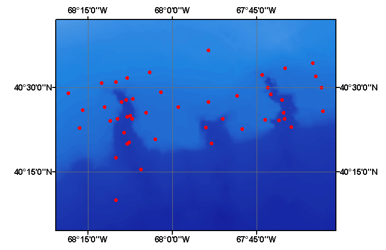
- Browse_Graphic:
-
- Browse_Graphic_File_Name: schwartz65
- Browse_Graphic_File_Description:
-
Image map showing extent and distribution of data layer coverage.
- Browse_Graphic_File_Type: GIF
- Data_Set_Credit:
-
Please review the cross reference information for the original data set credit to J.Schwartz. Larry Poppe for creating the ArcView shapefile.
- Native_Data_Set_Environment:
-
Microsoft Windows 2000 Version 5.1 (Build 2600) ; ESRI ArcCatalog 8.2.0.700
- Cross_Reference:
-
- Citation_Information:
-
- Originator: James Schwartz
- Publication_Date: 1965
- Title:
-
The Geology of Oceanographer, Gilbert, and Lydonia Submarine Canyons South of Georges Bank, off the Northeastern U.S.
- Edition: 1.0
- Series_Information:
-
- Series_Name: Master's Thesis
- Publication_Information:
-
- Publication_Place: Kingston, RI
- Publisher: University of Rhode Island
- Data_Quality_Information:
-
- Attribute_Accuracy:
-
- Attribute_Accuracy_Report:
-
All attributes were checked by the compilers in a consistent manner.
- Logical_Consistency_Report:
-
No additional checks for topological consistency were performed on these data.
- Completeness_Report:
-
Grain-size data, textural descriptions, navigation, and identifiers are provided for 50 stations.
- Positional_Accuracy:
-
- Horizontal_Positional_Accuracy:
-
- Horizontal_Positional_Accuracy_Report:
-
Navigation was by Loran A. Inasmuch as the shore locations were not reported and the accuracy of Loran A is dependent on the distance from the stations, accuracy of the navigation is unknown.
- Lineage:
-
- Source_Information:
-
- Source_Citation:
-
- Citation_Information:
-
- Originator: James Schwartz
- Publication_Date: 1965
- Title:
-
The geology of Oceanographer, Gilbert, and Lydonia submarine canyons south of Georges Bank, off the northeastern U.S.
- Edition: 1.0
- Series_Information:
-
- Series_Name: Master's Thesis
- Publication_Information:
-
- Publication_Place: Kingston, RI
- Publisher: University of Rhode Island
- Type_of_Source_Media: paper
- Source_Time_Period_of_Content:
-
- Time_Period_Information:
-
- Single_Date/Time:
-
- Calendar_Date: 1965
- Source_Currentness_Reference: publication date
- Process_Step:
-
- Process_Description:
-
The data were obtained from the National Geophysical Data Center and imported from an ASCII text file to an ArcView table. The table was later converted to an event theme in ArcView and saved as the final shapefile.
- Source_Used_Citation_Abbreviation: schwartz65.txt
- Process_Date: 20020912
- Source_Produced_Citation_Abbreviation: schwartz65.shp
- Source_Produced_Citation_Abbreviation: schwartz65.dbf
- Source_Produced_Citation_Abbreviation: schwartz65.shx
- Process_Contact:
-
- Contact_Information:
-
- Contact_Person_Primary:
-
- Contact_Person: Lawrence J. Poppe
- Contact_Organization: U.S. Geological Survey
- Contact_Position: Geologist
- Contact_Address:
-
- Address_Type: mailing and physical address
- Address: 384 Woods Hole Road
- City: Woods Hole
- State_or_Province: MA
- Postal_Code: 02543-1598
- Country: USA
- Contact_Voice_Telephone: 508-548-8700 x2314
- Contact_Facsimile_Telephone: 508-457-2310
- Contact_Electronic_Mail_Address: lpoppe@usgs.gov
- Spatial_Data_Organization_Information:
-
- Direct_Spatial_Reference_Method: Vector
- Point_and_Vector_Object_Information:
-
- SDTS_Terms_Description:
-
- SDTS_Point_and_Vector_Object_Type: Entity point
- Point_and_Vector_Object_Count: 50
- Spatial_Reference_Information:
-
- Horizontal_Coordinate_System_Definition:
-
- Geographic:
-
- Latitude_Resolution: 0.001
- Longitude_Resolution: 0.001
- Geographic_Coordinate_Units: Decimal degrees
- Geodetic_Model:
-
- Horizontal_Datum_Name: North American Datum of 1927
- Ellipsoid_Name: Clarke 1866
- Semi-major_Axis: 6378206.400000
- Denominator_of_Flattening_Ratio: 294.978698
- Entity_and_Attribute_Information:
-
- Detailed_Description:
-
- Entity_Type:
-
- Entity_Type_Label: schwartz65.dbf
- Entity_Type_Definition: Shapefile Attribute Table
- Entity_Type_Definition_Source: ESRI
- Attribute:
-
- Attribute_Label: FID
- Attribute_Definition: Internal feature number.
- Attribute_Definition_Source: ESRI
- Attribute_Domain_Values:
-
- Unrepresentable_Domain:
-
Sequential unique whole numbers that are automatically generated.
- Attribute:
-
- Attribute_Label: Shape
- Attribute_Definition: Feature geometry.
- Attribute_Definition_Source: ESRI
- Attribute_Domain_Values:
-
- Unrepresentable_Domain: Coordinates defining the features.
- Attribute:
-
- Attribute_Label: CONSECNO
- Attribute_Definition: Sequential number assigned to a data record
- Attribute_Definition_Source: Compiler
- Attribute_Domain_Values:
-
- Range_Domain:
-
- Range_Domain_Minimum: 1
- Range_Domain_Maximum: 50
- Attribute_Units_of_Measure: station
- Attribute_Measurement_Resolution: 1
- Attribute:
-
- Attribute_Label: PROJECTID
- Attribute_Definition: Name assigned to the data set for future identification
- Attribute_Definition_Source: Compiler
- Attribute_Domain_Values:
-
- Enumerated_Domain:
-
- Enumerated_Domain_Value: SCHWARTZ65
- Enumerated_Domain_Value_Definition: Scientist and publication year
- Enumerated_Domain_Value_Definition_Source: Compiler
- Attribute:
-
- Attribute_Label: CRUISEID
- Attribute_Definition: Cruise identifier
- Attribute_Definition_Source: Scientist
- Attribute_Domain_Values:
-
- Enumerated_Domain:
-
- Enumerated_Domain_Value: TR-018
- Enumerated_Domain_Value_Definition: Abbreviated name of ship (Trident) and cruise number
- Enumerated_Domain_Value_Definition_Source: Scientist
- Attribute:
-
- Attribute_Label: STATION
- Attribute_Definition: Unique identifier assigned to the sampling sites
- Attribute_Definition_Source: Scientist
- Attribute_Domain_Values:
-
- Unrepresentable_Domain: Numbers and characters designating the stations
- Attribute:
-
- Attribute_Label: DEVICE
- Attribute_Definition: Equipment used to collect samples
- Attribute_Definition_Source: Scientist
- Attribute_Domain_Values:
-
- Unrepresentable_Domain: Van Veen Grab and Gravity Core
- Attribute:
-
- Attribute_Label: DATE
- Attribute_Definition: Date when samples were collected
- Attribute_Definition_Source: Scientist
- Attribute_Domain_Values:
-
- Enumerated_Domain:
-
- Enumerated_Domain_Value: 196407
- Enumerated_Domain_Value_Definition: Year and month
- Enumerated_Domain_Value_Definition_Source: Scientist
- Attribute:
-
- Attribute_Label: LATITUDE
- Attribute_Definition: Latitude coordinate of sample location
- Attribute_Definition_Source: Scientist
- Attribute_Domain_Values:
-
- Range_Domain:
-
- Range_Domain_Minimum: 40.167
- Range_Domain_Maximum: 40.610
- Attribute_Units_of_Measure: decimal degrees
- Attribute_Measurement_Resolution: 0.001
- Attribute:
-
- Attribute_Label: LONGITUDE
- Attribute_Definition: Longitude coordinate of sample location
- Attribute_Definition_Source: Scientist
- Attribute_Domain_Values:
-
- Range_Domain:
-
- Range_Domain_Minimum: -68.308
- Range_Domain_Maximum: -67.553
- Attribute_Units_of_Measure: decimal degrees
- Attribute_Measurement_Resolution: 0.001
- Attribute:
-
- Attribute_Label: DEPTH
- Attribute_Definition: Water depth
- Attribute_Definition_Source: Scientist
- Attribute_Domain_Values:
-
- Range_Domain:
-
- Range_Domain_Minimum: 95
- Range_Domain_Maximum: 1700
- Attribute_Units_of_Measure: meters
- Attribute_Measurement_Resolution: 1
- Attribute:
-
- Attribute_Label: DOMINANT_L
- Attribute_Definition: Primary lithology
- Attribute_Definition_Source: Scientist
- Attribute_Domain_Values:
-
- Unrepresentable_Domain: Major lithologic component of the sediment
- Attribute:
-
- Attribute_Label: SECOND_LIT
- Attribute_Definition: Secondary lithologic component of the sediments
- Attribute_Definition_Source: Scientst
- Attribute_Domain_Values:
-
- Unrepresentable_Domain: Lithologic component of the sediment
- Attribute:
-
- Attribute_Label: GRAVEL
- Attribute_Definition: Percentage of gravel in the sample
- Attribute_Definition_Source: Scientist
- Attribute_Domain_Values:
-
- Range_Domain:
-
- Range_Domain_Minimum: 0
- Range_Domain_Maximum: 72.7
- Attribute_Units_of_Measure: percent
- Attribute_Measurement_Resolution: 0.1
- Attribute:
-
- Attribute_Label: SAND
- Attribute_Definition: Percentage of sand in the sample
- Attribute_Definition_Source: Scientist
- Attribute_Domain_Values:
-
- Range_Domain:
-
- Range_Domain_Minimum: 0
- Range_Domain_Maximum: 99.4
- Attribute_Units_of_Measure: percent
- Attribute_Measurement_Resolution: 0.1
- Attribute:
-
- Attribute_Label: SILT
- Attribute_Definition: Percentage of silt in sample
- Attribute_Definition_Source: Scientist
- Attribute_Domain_Values:
-
- Range_Domain:
-
- Range_Domain_Minimum: 0
- Range_Domain_Maximum: 64.9
- Attribute_Units_of_Measure: percent
- Attribute_Measurement_Resolution: 0.1
- Attribute:
-
- Attribute_Label: CLAY
- Attribute_Definition: Percentage of clay in sample
- Attribute_Definition_Source: Scientist
- Attribute_Domain_Values:
-
- Range_Domain:
-
- Range_Domain_Minimum: 0
- Range_Domain_Maximum: 46.9
- Attribute_Units_of_Measure: percent
- Attribute_Measurement_Resolution: 0.1
- Attribute:
-
- Attribute_Label: SHEPARD_CL
- Attribute_Definition:
-
Textural classification based on a scheme devised by Shepard (1954)
- Attribute_Definition_Source: Compiler
- Attribute_Domain_Values:
-
- Unrepresentable_Domain: Textural Classification
- Overview_Description:
-
- Entity_and_Attribute_Overview:
-
Grain-size data, textural descriptions, lithologic descriptions, navigation, and cruise, project, and sample identifiers.
- Distribution_Information:
-
- Distributor:
-
- Contact_Information:
-
- Contact_Person_Primary:
-
- Contact_Person: Lawrence J. Poppe
- Contact_Organization: U.S. Geological Survey
- Contact_Position: Geologist
- Contact_Address:
-
- Address_Type: mailing and physical address
- Address: 384 Woods Hole Road
- City: Woods Hole
- State_or_Province: MA
- Postal_Code: 02543-1598
- Country: USA
- Contact_Voice_Telephone: 508-548-8700 x2314
- Contact_Facsimile_Telephone: 508-457-2310
- Contact_Electronic_Mail_Address: lpoppe@usgs.gov
- Resource_Description:
-
Regional Mapping of Surficial Sediments: Gulf of Maine and Georges Bank, Aggregates and Habitats Projects, schwartz65.shp
- Distribution_Liability:
-
Although this data set has been used by the U.S. Geological Survey, no warranty, expressed or implied, is made by the USGS as to the accuracy of the data and/or related materials. The act of distribution shall not constitute any such warranty, and no responsibility is assumed by the USGS in the use of these data or related materials.
- Standard_Order_Process:
-
- Digital_Form:
-
- Digital_Transfer_Information:
-
- Format_Name: ArcView shapefile
- Format_Version_Number: 3.2
- Format_Specification: ESRI point shapefile
- Format_Information_Content:
-
Five files (schwartz65.shp, schwartz65.dbf, schwartz65.shx, schwartz65.sbx, schwartz65.sbn) comprising the ArcView point shapefile components, 'prj' and 'avl' files, metadata text file and browse graphic.
- File_Decompression_Technique: zip
- Transfer_Size: 0.136
- Digital_Transfer_Option:
-
- Offline_Option:
-
- Offline_Media: CD-ROM
- Recording_Capacity:
-
- Recording_Density: 650
- Recording_Density_Units: Mbytes
- Compatibility_Information:
-
The user must have a computer system with a CD-ROM available. To browse the information contained on this CD-ROM, the user must have a current WWW browser available. The user must also have software installed on their computer to unzip the archived file.
- Fees: None
- Technical_Prerequisites:
-
The data is available in ArcView shapefile format. The user must have ArcView 3.0 or greater software to read and process the data file. In lieu of ArcView, the user may utilize another GIS application package capable of importing data.
- Available_Time_Period:
-
- Time_Period_Information:
-
- Single_Date/Time:
-
- Calendar_Date: 2002
- Metadata_Reference_Information:
-
- Metadata_Date: 20030216
- Metadata_Contact:
-
- Contact_Information:
-
- Contact_Person_Primary:
-
- Contact_Person: Lawrence J. Poppe
- Contact_Organization: U.S. Geological Survey
- Contact_Position: Geologist
- Contact_Address:
-
- Address_Type: mailing and physical address
- Address: 384 Woods Hole Road
- City: Woods Hole
- State_or_Province: MA
- Postal_Code: 02543-1598
- Country: USA
- Contact_Voice_Telephone: 508-548-8700 x2314
- Contact_Facsimile_Telephone: 508-457-2310
- Contact_Electronic_Mail_Address: lpoppe@usgs.gov
- Metadata_Standard_Name: FGDC Content Standards for Digital Geospatial Metadata
- Metadata_Standard_Version: FGDC-STD-001-1998
- Metadata_Time_Convention: local time
- Metadata_Access_Constraints: None
- Metadata_Use_Constraints: None
Generated by mp version 2.7.3 on Sun Feb 16 11:28:29 2003
OFR03-001 Home | Introduction
| Nomenclature | Browse
Maps | Data Catalog | Data
Dictionary
[an error occurred while processing this directive]