|
 |
| U.S. Geological Survey
Open-File Report 03-001 |
|
|
WIGLEY65: Fisheries Sediment Data
|
Metadata also available as: FAQ - TEXT
Metadata:
- Identification_Information:
-
- Citation:
-
- Citation_Information:
-
- Originator: Lawrence J. Poppe
- Publication_Date: 2003
- Title: WIGLEY65: Fisheries Sediment Data
- Edition: 1.0
- Geospatial_Data_Presentation_Form: vector digital data
- Series_Information:
- Publication_Information:
-
- Publication_Place: Woods Hole Field Center, Woods Hole, MA
- Publisher: U. S. Geological Survey, Coastal and Marine Geology Program
- Online_Linkage:
-
<http://pubs.usgs.gov/of/2003/of03-001/data/seddata/wigley65/wigley65.zip>
- Online_Linkage:
-
<http://pubs.usgs.gov/of/2003/of03-001/data/seddata/wigley65/wigley65.zip>
- Larger_Work_Citation:
-
- Citation_Information:
-
- Originator: L.J. Poppe
- Originator: V.F. Paskevich
- Originator: S.J. Williams
- Originator: M.E. Hastings
- Originator: J.T. Kelley
- Originator: D.F. Belknap
- Originator: L.G. Ward
- Originator: D.M. FitzGerald
- Originator: P.F. Larsen
- Publication_Date: 2003
- Title:
-
Surficial Sediment Data from the Gulf of Maine, Georges Bank, and Vicinity: a GIS Compilation
- Edition: 1.0
- Series_Information:
-
- Series_Name: Open-File Report
- Issue_Identification: 03-001
- Publication_Information:
-
- Publication_Place: Woods Hole Field Center, Woods Hole, MA
- Publisher: U. S. Geological Survey, Coastal and Marine Geology Program
- Other_Citation_Details:
-
Data are released via CD-ROM media. This digital publication may also be available via the web at pubs.usgs.gov
- Online_Linkage: <http://pubs.usgs.gov/of/2003/of03-001>
- Online_Linkage: <http://pubs.usgs.gov/of/2003/of03-001>
- Description:
-
- Abstract:
-
This is a part of the National Geophysical Data Center (NGDC) Seafloor Surficial Sediment (Deck 41) Data File. Deck 41 is an original data file created by the Marine Geology and Geophysics Group of NGDC from 1970-1975, abstracted from unpublished material contributed to NGDC by multiple groups of individuals. No updates of Deck 41 have been added since 1975. The data that comprise this portion of Deck 41 were generated by R.L. Wigley during 1965 aboard ALBATROSS IV cruises 65-2, 65-13, and 65-14.
- Purpose:
-
The purpose of this data layer is to provide a part of the Deck 41 data file in a form that could be used to interpret surficial sediment distributions off the northeastern United States.
- Time_Period_of_Content:
-
- Time_Period_Information:
-
- Range_of_Dates/Times:
-
- Beginning_Date: 19650115
- Ending_Date: 19651109
- Currentness_Reference: ground condition
- Status:
-
- Progress: Complete
- Maintenance_and_Update_Frequency: None planned
- Spatial_Domain:
-
- Bounding_Coordinates:
-
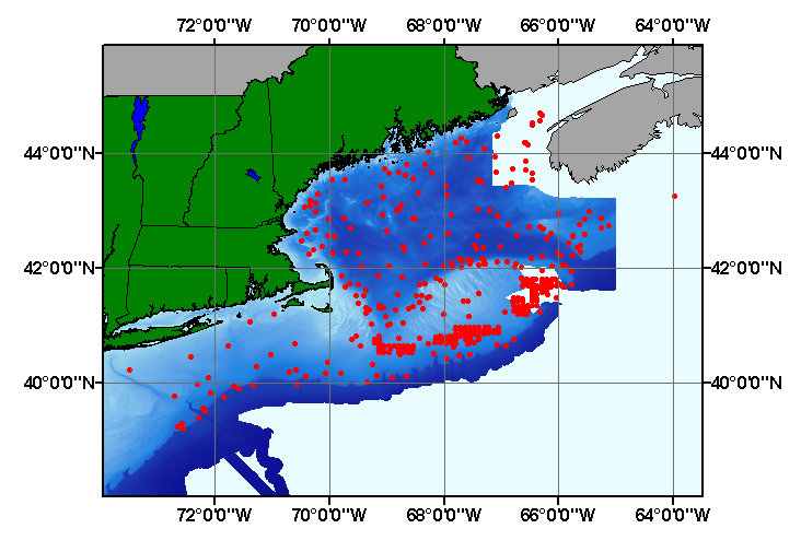
- West_Bounding_Coordinate: -73.467000
- East_Bounding_Coordinate: -63.967000
- North_Bounding_Coordinate: 44.700000
- South_Bounding_Coordinate: 39.200000
- Keywords:
-
- Theme:
-
- Theme_Keyword_Thesaurus: General
- Theme_Keyword: U.S. Geological Survey
- Theme_Keyword: USGS
- Theme_Keyword: Coastal and Marine Geology Program
- Theme_Keyword: Woods Hole Field Center
- Theme_Keyword: National Geophysical Data Center
- Theme_Keyword: NGDC
- Theme_Keyword: Bureau of Commercial Fisheries
- Theme_Keyword: Deck 41
- Theme_Keyword: sediment
- Theme_Keyword: texture
- Theme_Keyword: gravel
- Theme_Keyword: sand
- Theme_Keyword: silt
- Theme_Keyword: clay
- Theme_Keyword: CMGP
- Theme_Keyword: sediment classification
- Theme_Keyword: gravel
- Theme_Keyword: sand
- Theme_Keyword: silt
- Theme_Keyword: clay
- Theme_Keyword: Open-File Report 03-001
- Theme_Keyword: ALBATROSS-IV cruises
- Theme_Keyword: ALBATROSS IV cruise 65-2
- Theme_Keyword: ALBATROSS IV cruise 65-13
- Theme_Keyword: ALBATROSS IV cruise 65-14.
- Theme_Keyword: surficial classification
- Theme_Keyword: GIS
- Theme_Keyword: Geographic Information System
- Theme_Keyword: ArcView shapefile
- Theme_Keyword: points
- Place:
-
- Place_Keyword_Thesaurus: General
- Place_Keyword: U.S. East Coast
- Place_Keyword: Atlantic
- Place_Keyword: Gulf of Maine
- Place_Keyword: Georges Bank
- Place_Keyword: outer continental shelf
- Place_Keyword: US northeast
- Access_Constraints: None
- Use_Constraints: None
- Point_of_Contact:
-
- Contact_Information:
-
- Contact_Person_Primary:
-
- Contact_Person: Lawrence J. Poppe
- Contact_Organization: U.S. Geological Survey
- Contact_Position: Geologist
- Contact_Address:
-
- Address_Type: mailing and physical address
- Address: 384 Woods Hole Road
- City: Woods Hole
- State_or_Province: MA
- Postal_Code: 02543-1598
- Country: USA
- Contact_Voice_Telephone: 508-548-8700 x2314
- Contact_Facsimile_Telephone: 508-457-2310
- Contact_Electronic_Mail_Address: lpoppe@usgs.gov
- Browse_Graphic:
-
- Browse_Graphic_File_Name: wigley65
- Browse_Graphic_File_Description:
-
Image map showing extent and distribution of data layer coverage.
- Browse_Graphic_File_Type: GIF
- Data_Set_Credit:
-
National Geophysical Data Center (NGDC) for supplying the original unpublished data sheets; Larry Poppe for creating the shapefile.
- Native_Data_Set_Environment:
-
Microsoft Windows 2000 Version 5.1 (Build 2600) ; ESRI ArcCatalog 8.2.0.700
- Cross_Reference:
-
- Citation_Information:
-
- Originator: R.L. Wigley
- Publication_Date: Unpublished Material
- Title: Raw Data Sheets
- Edition: 1.0
- Publication_Information:
-
- Publication_Place: Woods Hole, MA
- Publisher: Bureau of Commercial Fisheries
- Other_Citation_Details:
-
Data collected during 1965 aboard the ALBATROSS IV during cruises 65-2, 65-13, and 65-14
- Data_Quality_Information:
-
- Attribute_Accuracy:
-
- Attribute_Accuracy_Report:
-
All attributes were checked by the compilers in a consistent manner.
- Logical_Consistency_Report:
-
No additional checks for topological consistency were performed on this data.
- Completeness_Report:
-
This data set contains fields that are only a subset of those fields in the NGDC Seafloor Surficial Sediment (Deck 41) Data File. This data set contains grain-size data, textural descriptions, navigation, and sample identifiers for 383 stations.
- Positional_Accuracy:
-
- Horizontal_Positional_Accuracy:
-
- Horizontal_Positional_Accuracy_Report:
-
No information on navigational methods was provided with this data set , but navigation was probably by Loran A. Navigational accuracy is unknown.
- Lineage:
-
- Source_Information:
-
- Source_Citation:
-
- Citation_Information:
-
- Originator: R.L. Wigley
- Publication_Date: Unpublished Material
- Title: Raw Data Sheets
- Edition: 1.0
- Publication_Information:
-
- Publication_Place: Woods Hole, MA
- Publisher: Bureau of Commercial Fisheries
- Other_Citation_Details:
-
Data collected during 1965 aboard the ALBATROSS IV during cruises 65-2, 65-13, and 65-14
- Type_of_Source_Media: Scanned raw data sheets
- Source_Time_Period_of_Content:
-
- Time_Period_Information:
-
- Single_Date/Time:
-
- Calendar_Date: 1965
- Source_Currentness_Reference: ground condition
- Process_Step:
-
- Process_Description:
-
Scanned images of the original raw data sheets were downloaded from the NGDC Seafloor Surficial Sediment (Deck 41) Data File. Lithologic descriptions, grain-size data, and sample identifiers were manually entered into Microsoft Excel and saved as an ASCII text file. The ASCII file was imported to an ArcView table. The table was later converted to an event theme in ArcView and saved as the final shapefile.
- Source_Used_Citation_Abbreviation: wigley65.txt
- Process_Date: 20020913
- Source_Produced_Citation_Abbreviation: wigley65.shp
- Source_Produced_Citation_Abbreviation: wigley65.dbf
- Source_Produced_Citation_Abbreviation: wigley65.shx
- Process_Contact:
-
- Contact_Information:
-
- Contact_Person_Primary:
-
- Contact_Person: Lawrence J. Poppe
- Contact_Organization: U.S. Geological Survey
- Contact_Position: Geologist
- Contact_Address:
-
- Address_Type: mailing and physical address
- Address: 384 Woods Hole Road
- City: Woods Hole
- State_or_Province: MA
- Postal_Code: 02543-1598
- Country: USA
- Contact_Voice_Telephone: 508-548-8700 x2314
- Contact_Facsimile_Telephone: 508-457-2310
- Contact_Electronic_Mail_Address: lpoppe@usgs.gov
- Spatial_Data_Organization_Information:
-
- Direct_Spatial_Reference_Method: Vector
- Point_and_Vector_Object_Information:
-
- SDTS_Terms_Description:
-
- SDTS_Point_and_Vector_Object_Type: Entity point
- Point_and_Vector_Object_Count: 383
- Spatial_Reference_Information:
-
- Horizontal_Coordinate_System_Definition:
-
- Geographic:
-
- Latitude_Resolution: 0.001
- Longitude_Resolution: 0.001
- Geographic_Coordinate_Units: Decimal degrees
- Geodetic_Model:
-
- Horizontal_Datum_Name: North American Datum of 1927
- Ellipsoid_Name: Clarke 1866
- Semi-major_Axis: 6378206.400000
- Denominator_of_Flattening_Ratio: 294.978698
- Entity_and_Attribute_Information:
-
- Detailed_Description:
-
- Entity_Type:
-
- Entity_Type_Label: wigley65.dbf
- Entity_Type_Definition: Shapefile Attribute Table
- Entity_Type_Definition_Source: ESRI
- Attribute:
-
- Attribute_Label: FID
- Attribute_Definition: Internal feature number.
- Attribute_Definition_Source: ESRI
- Attribute_Domain_Values:
-
- Unrepresentable_Domain:
-
Sequential unique whole numbers that are automatically generated.
- Attribute:
-
- Attribute_Label: Shape
- Attribute_Definition: Feature geometry.
- Attribute_Definition_Source: ESRI
- Attribute_Domain_Values:
-
- Unrepresentable_Domain: Coordinates defining the features.
- Attribute:
-
- Attribute_Label: PROJECTID
- Attribute_Definition: Name assigned to the data set for future identification.
- Attribute_Definition_Source: Compiler
- Attribute_Domain_Values:
-
- Enumerated_Domain:
-
- Enumerated_Domain_Value: WIGLEY1965
- Enumerated_Domain_Value_Definition: Scientist and year samples were collected.
- Enumerated_Domain_Value_Definition_Source: Data Compiler
- Attribute:
-
- Attribute_Label: AREA
- Attribute_Definition: Geographic area in and around which the samples were collected.
- Attribute_Definition_Source: Scientist
- Attribute_Domain_Values:
-
- Enumerated_Domain:
-
- Enumerated_Domain_Value: GULF OF MAINE
- Enumerated_Domain_Value_Definition: Gulf of Maine region
- Enumerated_Domain_Value_Definition_Source: Compiler
- Attribute:
-
- Attribute_Label: CONSEC_NO
- Attribute_Definition:
-
Consecutive numbers and suffix assigned to samples (numbers reset for each cruise).
- Attribute_Definition_Source: Compiler
- Attribute_Domain_Values:
-
- Unrepresentable_Domain:
-
Character string containing the assigned consecutive number and, where appropriate, additional identification suffix.
- Attribute:
-
- Attribute_Label: CRUISEID
- Attribute_Definition: Cruise identifier
- Attribute_Definition_Source: Scientist
- Attribute_Domain_Values:
-
- Unrepresentable_Domain:
-
Character string containing the abbreviated name of vessel (AB= ALBATROSS IV) and number designation the cruise
- Attribute_Domain_Values:
-
- Enumerated_Domain:
-
- Enumerated_Domain_Value: AB2
- Enumerated_Domain_Value_Definition: Albatross-IV; Leg 2
- Enumerated_Domain_Value_Definition_Source: Woods Hole Oceanographic data archive and cruise curator
- Attribute_Domain_Values:
-
- Enumerated_Domain:
-
- Enumerated_Domain_Value: AB13
- Enumerated_Domain_Value_Definition: Albatross-IV; Leg 13
- Enumerated_Domain_Value_Definition_Source: Woods Hole Oceanographic data archive and cruise curator
- Attribute_Domain_Values:
-
- Enumerated_Domain:
-
- Enumerated_Domain_Value: AB14
- Enumerated_Domain_Value_Definition: Albatross-IV; Leg 14
- Enumerated_Domain_Value_Definition_Source: Woods Hole Oceanographic data archive and cruise curator
- Attribute:
-
- Attribute_Label: STATION
- Attribute_Definition: Number assigned to the station.
- Attribute_Definition_Source: Scientist
- Attribute_Domain_Values:
-
- Unrepresentable_Domain:
-
Character string containing the station number and, where necessary, additional station identifier suffix.
- Attribute:
-
- Attribute_Label: DEVICE
- Attribute_Definition: Sampler used to collect sediment
- Attribute_Definition_Source: Scientist
- Attribute_Domain_Values:
-
- Unrepresentable_Domain: Character string containing name of sampler
- Attribute_Domain_Values:
-
- Enumerated_Domain:
-
- Enumerated_Domain_Value: PIPE DREDGE
- Enumerated_Domain_Value_Definition: Pipe dredge
- Enumerated_Domain_Value_Definition_Source: Scientist
- Enumerated_Domain:
-
- Enumerated_Domain_Value: DREDGE
- Enumerated_Domain_Value_Definition: Dredge sampler
- Enumerated_Domain_Value_Definition_Source: Scientist
- Attribute:
-
- Attribute_Label: DATE
- Attribute_Definition: Date during which samples were collected
- Attribute_Definition_Source: Scientist
- Attribute_Domain_Values:
-
- Unrepresentable_Domain:
-
Character string containing year, month and day (YYYYMMDD) sample was collected.
- Attribute:
-
- Attribute_Label: LATITUDE
- Attribute_Definition: Latitude coordinate ofsample location
- Attribute_Definition_Source: Scientist
- Attribute_Domain_Values:
-
- Range_Domain:
-
- Range_Domain_Minimum: 39.200
- Range_Domain_Maximum: 44.700
- Attribute_Units_of_Measure: Decimal degrees
- Attribute_Measurement_Resolution: 0.001
- Attribute:
-
- Attribute_Label: LONGITUDE
- Attribute_Definition: Longitude coordinate of sample location
- Attribute_Definition_Source: Scientist
- Attribute_Domain_Values:
-
- Range_Domain:
-
- Range_Domain_Minimum: -73.467
- Range_Domain_Maximum: -63.967
- Attribute_Units_of_Measure: Decimal degrees
- Attribute_Measurement_Resolution: 0.001
- Attribute:
-
- Attribute_Label: DEPTH
- Attribute_Definition: Water depth of sample
- Attribute_Definition_Source: Scientist
- Attribute_Domain_Values:
-
- Range_Domain:
-
- Range_Domain_Minimum: 33
- Range_Domain_Maximum: 348
- Attribute_Units_of_Measure: meters
- Attribute_Measurement_Resolution: 1
- Attribute:
-
- Attribute_Label: SHELL
- Attribute_Definition: Percentage of shells in the sample
- Attribute_Definition_Source: Scientist
- Attribute_Domain_Values:
-
- Unrepresentable_Domain:
-
Character string containing a mixture of numbers and verbal comments
- Attribute:
-
- Attribute_Label: COLOR
- Attribute_Definition: Color of the sediments
- Attribute_Definition_Source: Scientist
- Attribute_Domain_Values:
-
- Unrepresentable_Domain:
-
Character string containing the comments on the color of the sediments
- Attribute:
-
- Attribute_Label: GRAVEL
- Attribute_Definition: Percentage of gravel in the sample
- Attribute_Definition_Source: Scientist
- Attribute_Domain_Values:
-
- Unrepresentable_Domain:
-
Character string containing a mixture of numbers and verbal descriptions
- Attribute:
-
- Attribute_Label: SAND
- Attribute_Definition: Percentage of sand in the sample
- Attribute_Definition_Source: Scientist
- Attribute_Domain_Values:
-
- Unrepresentable_Domain:
-
Character string containing a mixture of numbers and verbal descriptions
- Attribute:
-
- Attribute_Label: SILT
- Attribute_Definition: Percentage of silt in the sample
- Attribute_Definition_Source: Scientist
- Attribute_Domain_Values:
-
- Unrepresentable_Domain:
-
Character string containing a mixture of numbers and verbal descriptions
- Attribute:
-
- Attribute_Label: CLAY
- Attribute_Definition: Percentage of clay in the sample
- Attribute_Definition_Source: Scientist
- Attribute_Domain_Values:
-
- Unrepresentable_Domain:
-
Character string containing a mixture of numbers and verbal descriptions
- Attribute:
-
- Attribute_Label: FINES
- Attribute_Definition: Percentage of silt plus clay in the sample
- Attribute_Definition_Source: Scientist
- Attribute_Domain_Values:
-
- Unrepresentable_Domain:
-
Character string containing a mixture of numbers and verbal descriptions
- Attribute:
-
- Attribute_Label: CLASS
- Attribute_Definition: Classification of sediment texture
- Attribute_Definition_Source: Scientist
- Attribute_Domain_Values:
-
- Unrepresentable_Domain:
-
Character string containing verbal descriptions of sediment texture
- Attribute_Domain_Values:
-
- Enumerated_Domain:
-
- Enumerated_Domain_Value: CLAY
- Enumerated_Domain_Value_Definition: Clay content
- Enumerated_Domain_Value_Definition_Source: Scientist
- Enumerated_Domain:
-
- Enumerated_Domain_Value: FINE SAND
- Enumerated_Domain_Value_Definition: fine sand content
- Enumerated_Domain_Value_Definition_Source: Scientist
- Enumerated_Domain:
-
- Enumerated_Domain_Value: GRAVEL
- Enumerated_Domain_Value_Definition: gravel content
- Enumerated_Domain_Value_Definition_Source: Scientist
- Enumerated_Domain:
-
- Enumerated_Domain_Value: GRAVEL, SILT-CLAY
- Enumerated_Domain_Value_Definition: gravel, cilt-clay content
- Enumerated_Domain_Value_Definition_Source: Scientist
- Enumerated_Domain:
-
- Enumerated_Domain_Value: GRAVELLY SAND
- Enumerated_Domain_Value_Definition: gravelly sand content
- Enumerated_Domain_Value_Definition_Source: Scientist
- Enumerated_Domain:
-
- Enumerated_Domain_Value: GRAVEL-SAND
- Enumerated_Domain_Value_Definition: gravel-sand content
- Enumerated_Domain_Value_Definition_Source: Scientist
- Enumerated_Domain:
-
- Enumerated_Domain_Value: SAND
- Enumerated_Domain_Value_Definition: sand content
- Enumerated_Domain_Value_Definition_Source: Scientist
- Enumerated_Domain:
-
- Enumerated_Domain_Value: SAND-GRAVEL
- Enumerated_Domain_Value_Definition: sand-gravel content
- Enumerated_Domain_Value_Definition_Source: Scientist
- Enumerated_Domain:
-
- Enumerated_Domain_Value: SAND-SILT
- Enumerated_Domain_Value_Definition: sand-silt content
- Enumerated_Domain_Value_Definition_Source: Scientist
- Enumerated_Domain:
-
- Enumerated_Domain_Value: SANDY GRAVEL
- Enumerated_Domain_Value_Definition: sandy-gravel content
- Enumerated_Domain_Value_Definition_Source: Scientist
- Enumerated_Domain:
-
- Enumerated_Domain_Value: SANDY SILT-CLAY
- Enumerated_Domain_Value_Definition: sandy silt-clay content
- Enumerated_Domain_Value_Definition_Source: Scientist
- Enumerated_Domain:
-
- Enumerated_Domain_Value: SILT
- Enumerated_Domain_Value_Definition: silt content
- Enumerated_Domain_Value_Definition_Source: Scientist
- Enumerated_Domain:
-
- Enumerated_Domain_Value: SILT CLAY
- Enumerated_Domain_Value_Definition: silty clay content
- Enumerated_Domain_Value_Definition_Source: Scientist
- Enumerated_Domain:
-
- Enumerated_Domain_Value: SILT-CLAY
- Enumerated_Domain_Value_Definition: silt-clay content
- Enumerated_Domain_Value_Definition_Source: Scientist
- Enumerated_Domain:
-
- Enumerated_Domain_Value: TILLOID
- Enumerated_Domain_Value_Definition_Source: Scientist
- Distribution_Information:
-
- Distributor:
-
- Contact_Information:
-
- Contact_Person_Primary:
-
- Contact_Person: Lawrence J. Poppe
- Contact_Organization: U.S. Geological Survey
- Contact_Position: Geologist
- Contact_Address:
-
- Address_Type: mailing and physical address
- Address: 384 Woods Hole Road
- City: Woods Hole
- State_or_Province: MA
- Postal_Code: 02543-1598
- Country: USA
- Contact_Voice_Telephone: 508-548-8700 x2314
- Contact_Facsimile_Telephone: 508-457-2310
- Contact_Electronic_Mail_Address: lpoppe@usgs.gov
- Resource_Description:
-
Shapefile containg the grain-size data, textural descriptions, and sample identifiers for unpublished data generated by the Bureau of Marine Fisheries and disseminated by NGDC.
Regional Mapping of Surficial Sediments: Gulf of Maine and Georges Bank, Aggregates and Habitats Projects, wigley65.shp
- Distribution_Liability:
-
Although this data set has been used by the U.S. Geological Survey, no warranty, expressed or implied, is made by the USGS as to the accuracy of the data and/or related materials. The act of distribution shall not constitute any such warranty, and no responsibility is assumed by the USGS in the use of these data or related materials.
- Standard_Order_Process:
-
- Digital_Form:
-
- Digital_Transfer_Information:
-
- Format_Name: ArcView shapefile
- Format_Version_Number: 3.2
- Format_Specification: ESRI point sapefile
- Format_Information_Content:
-
Five files (wigley65.shp, wigley65.shx, wigley65.dbf, wigley65.sbx, wigley65.sbn) comprising the ArcView point shapefile components, 'prj' and 'avl' files, metadata text file and browse graphic.
- File_Decompression_Technique: zip
- Transfer_Size: 0.213
- Digital_Transfer_Option:
-
- Offline_Option:
-
- Offline_Media: CD-ROM
- Recording_Capacity:
-
- Recording_Density: 650
- Recording_Density_Units: Mbytes
- Compatibility_Information:
-
The user must have a computer system with a CD-ROM available. To browse the information contained on this CD-ROM, the user must have a current WWW browser available. The user must also have software installed on their computer to unzip the archived file.
- Fees: None
- Technical_Prerequisites:
-
The data is available in ArcView shapefile format. The user must have ArcView 3.0 or greater software to read and process the data file. In lieu of ArcView, the user may utilize another GIS application package capable of importing data.
- Metadata_Reference_Information:
-
- Metadata_Date: 20030326
- Metadata_Contact:
-
- Contact_Information:
-
- Contact_Person_Primary:
-
- Contact_Person: Lawrence J. Poppe
- Contact_Organization: U.S. Geological Survey
- Contact_Position: Geologist
- Contact_Address:
-
- Address_Type: mailing and physical address
- Address: 384 Woods Hole Road
- City: Woods Hole
- State_or_Province: MA
- Postal_Code: 02543-1598
- Country: USA
- Contact_Voice_Telephone: 508-548-8700 x2314
- Contact_Facsimile_Telephone: 508-457-2310
- Contact_Electronic_Mail_Address: lpoppe@usgs.gov
- Metadata_Standard_Name: FGDC Content Standards for Digital Geospatial Metadata
- Metadata_Standard_Version: FGDC-STD-001-1998
- Metadata_Time_Convention: local time
- Metadata_Access_Constraints: None
- Metadata_Use_Constraints: None
Generated by mp version 2.7.3 on Wed Mar 26 09:48:28 2003
OFR03-001 Home | Introduction
| Nomenclature | Browse
Maps | Data Catalog | Data
Dictionary
[an error occurred while processing this directive]