Coastal Vulnerability Assessment of
GUIS
,
USGS
Open-File Report 03-108
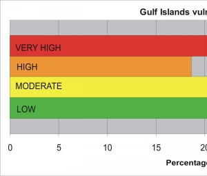
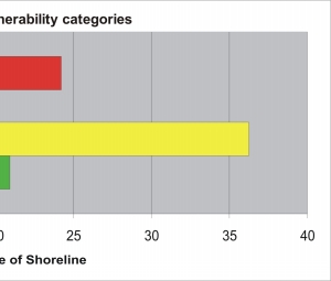
Figure 10.
Percentage of
GUIS
shoreline in each CVI vulnerability category.
Department of Interior
/
U.S. Geological Survey
/
Coastal and Marine Geology
/
USGS Privacy Statement
/
Disclaimer
/
Accessibility
This is http://pubs.usgs.gov/pubs/of/2003/of03-108/html/fig10.html
Maintained by
Eastern Publications Group
Modified Saturday, 12-Jan-2013 23:45:00 EST