OF 03-150 Home
CD-ROM
Contents
Project
Description
GIS Data
Contacts
|
CD-ROM Contents
Geophysical Surveys of Bear Lake, Utah-Idaho, September, 2002
USGS Open-File Report 03-150
by
Denny, J.F. and Colman, S.M.
U.S. Geological Survey, Woods Hole, MA
Table of Contents:
 Return to the top of page
Introduction
The U.S. Geological Survey, in cooperation with researchers from
several universities, has been studying the sediments of Bear Lake
since 1996. The general purpose of this effort is to reconstruct
past limnological conditions and regional climate on a range of
timescales, from hundreds of years to hundreds of thousands of years.
The objectives of the September, 2002 operations, preliminarily
reported here, were (1) to compile a detailed bathymetric map of
the lake using swath-mapping techniques, in order to provide baseline
data for a variety of applications and studies, and (2) to complete
a sidescan-sonar survey of the lake, providing a nearly complete
acoustic image of the lake floor. Limited amounts of subbottom acoustic-reflection
data (chirp) were also collected, along with samples of lake-floor
sediments representative of different kinds of backscatter patterns.
Return to the top of page
CD-ROM Contents
The contents of this CD-ROM are as follows:
Top level Directory:
- index.htm - This file is intended to be the starting
point for CD-ROM access. It is written in the Hypertext
Markup Language utilized by the World Wide Web (WWW)
project and must be opened with a WWW browser. Once
opened, the user may browse the CD-ROM's contents
as they would browse pages from the WWW.
- readme.txt - ASCII text file containing a description
of this CD-ROM. This file may be viewed or printed
with any system program capable of opening an ASCII text file.
Directories:
- arcview - this directory contains
the ESRI ArcView 3.2 project file, 03-150.apr
and the following directories:
- bathy - contains a TIFF
image of the bathymetric data and corresponding world file
- dem - contains the 10 meter Digital Elevation Model
stored in an ESRI
GRID format and as a TIFF
file with associated ESRI world file
- images -
- grab - contains the JPEG
images of the grab sample data
- seis- contains the JPEG
images of the seismic data
- svp - contains the JPEG
images of the sound velocity profiles
- metadata - contains the metadata for all the files
utilized within the project file
- mosaic- contains the following sidescan-sonar mosaic
files:
bear.tif/bear.tfw - full resolution TIFF
image (1 meter/pixel)
bear.sid/bear.sdw - MrSID compressed image file
- shape
- contains all of the shapefiles found within the project file,
subdivided as follows:
.
- html - contains all HTML pages accessed
within this CD-ROM.
- images - contains the image files utilized within
HTML pages
- PDF - contains PDF version of Figures
- nav - contains the seismic shot, sonar, and bathymetric navigation
file in ASCII format
- posters - contains two map sheets: Bathymetry (sheet 1)
and Sidescan-sonar (sheet 2) in PDF format. These files can be opened in
Adobe Acrobat or Adobe Illustrator and printed.
- svp - contains a Microsoft Excel file listing all sound
velocity profiles
Return to the top of page
Getting Started
3D Views
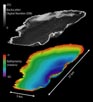 |
| Figure 10. Three-dimensional view of sidescan-sonar and bathymetry data collected
within Bear Lake, Utah-Idaho. |
Interactive Visualization Systems (IVS) Fledermaus software package was used
to view the sidescan-sonar and bathymetric data in three dimensions. Fledermaus
object and scene files were generated and are included on this
CD-ROM. These files can be viewed by downloading the IVS
free 3D viewer, iView3D, from IVS.
Download Information:
- Go to the IVS
website
- Go to Products
- Click on iView3D
This will take the User to the iView3D Home Page.
The User will find a program description and detailed downloading
instructions. It is highly recommended that the User download
iView3D in order to view the sidescan-sonar and
bathymetric data in three dimensions and 'fly-through' the study
area. The HELP within iView3D gives detailed
operating instructions.
Fledermaus Object and Scene Files:
The following files can be viewed within iView3D.
See iView3D HELP for detailed instructions.
- 3d.scene - bathymetry and sidescan-sonar
- sidescan.sd - sidescan-sonar image
- bathy.sd - bathymetric data
ESRI
An Environmental Systems Research Institute (ESRI)
ArcView 3.2 Geographic Information System (GIS) project
file, of03-150.apr, resides in the arcview directory.
All associated GIS files are also contained within
this directory. The user must have a copy of ESRI
ArcView 3.2 in order to view the project file. Visit the ESRI
website (http://www.esri.com) for information concerning this, and
other software, such as ArcExplorer, a free viewer available
for download.
To Load of03-150.apr:
- of03-150.apr contains a startup script, Drive Selection.
This script will run upon startup and will prompt the user for
the directory path to the images directory. This information
is needed in order to establish the 'hotlinks' found within the
project file. This script can also be accessed within the project file. Click on
the 'fireworks' button, found on the menu/button bar within of03-150,
to rerun the Drive Selection script. This button enables the user to modify the
directory path to the images directory at any time.
Extensions:
- Vector and point data are 'hotlinked' to JPEG image files
within of03-150.apr. The JPEG
(JFIF) Image Support extension must be loaded in order
to view these image files. This extension is loaded by default
within the project file.
- This project file utilizes RASTER image files (TIFF) compressed
with LizardTech (www.lizardtech.com)
MrSID Geospatial Encoder 1.3.1 image compression utility. In order
to load and view these files the MrSID Image Support
extension must be loaded. This extension will be loaded by
default within of03-150.apr.
Views:
The Bear Lake View within of03-150.apr is projected
in the following coordinate system: UTM,
WGS84 datum, Zone 12, meters. All raster images and
grids are also projected in UTM.
All point and vector data are stored in decimal degrees.
NOTE: Hotlinks - The seismic trackline data, sample and
sound velocity profile locations are 'hotlinked' to JPEG
images of the seismic data, photographs of the sediment samples,
and images of the sound velocity profiles, respectively. To view
the JPEG images,
activate either the trackline, sample or sound velocity profile
shapefile by clicking the shapefile
name within the View Table of Contents. Click on the lightening
bolt
within the tool menu bar, then click on an individual trackline
or sample location within the active theme. A JPEG
image of the seismic data collected along the chosen line will appear.
The JPEG images
are stored in a view window; the user can zoom, pan, and alter the
window size. Click on the X in the upper right corner to close the
window.
Return to the top of page
System Requirements
This CD-ROM can be successfully accessed on systems utilizing the following
operating systems: Microsoft Windows, Macintosh and UNIX. However, the
ESRI ArcView
project file, of03-152.apr, and the
IVS
free viewer, iView3D, will only run on Microsoft Windows systems.
Return to the top of page
Disclaimer
This Compact Disc-Read
Only Memory (CD-ROM) publication was prepared by an
agency of the United States Government. Neither the United States
Government nor any agency thereof, nor any of their employees, make
any warranty, expressed or implied, or assumes any legal liability
or responsibility for the accuracy, completeness, or usefulness
of any information, apparatus, product, or process disclosed in
this report, or represents that its use would not infringe privately
owned rights. Reference therein to any specific commercial product,
process, or service by trade name, trademark, manufacturer, or otherwise
does not necessarily constitute or imply its endorsement, recommendation,
or favoring by the United States Government or any agency thereof.
Any views and opinions of authors expressed herein do not necessarily
state or reflect those of the United States Government or any agency
thereof. Although all data published on this CD-ROM
have been used by the USGS, no warranty, expressed
or implied, is made by the USGS as to the accuracy
of the data and related materials and/or the functioning of the
software. The act of distribution shall not constitute any such
warranty, and no responsibility is assumed by the USGS
in the use of this data, software, or related materials.
To view files in PDF format, download free copy of Adobe Acrobat Reader www.adobe.com/products/acrobat/alternate.html.
|