skip headerUSGS: science for a changing world - www.usgs.gov
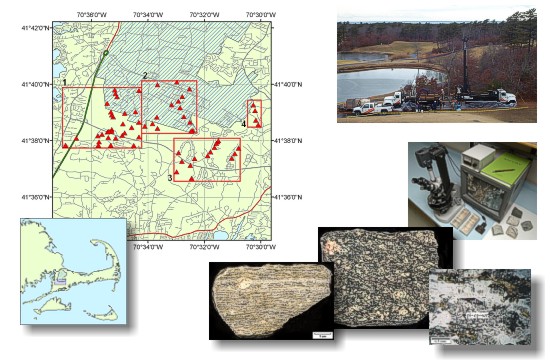
Coastal and Marine Geology Program  |  Woods Hole Science Center

U.S. Geological Survey Open-File Report 03-221

A Pictorial Survey of the Bedrock Beneath
Western Cape Cod, Massachusetts

By B.W. Hallett1, V. F. Paskevich2, L.J. Poppe2, S.G. Brand3, and D.S. Blackwood2

Skip navigation bar
OFR03-221 Home

Introduction

Bedrock Photographs

GIS Data Catalog

Photo Gallery

References

Acknowledgments

Contacts

Disclaimer

README


April 2004

OFR03-221 index image showing GIS data layers with location of bedrock cores and study area, drilling rig, examples of bedrock cores and thin section photomicrograph.

In collaboration with CH2M Hill, Boston Massachusetts.


1 - Department of Geological Sciences
University of Idaho
7th and Line
Moscow, ID  83844- 3022
 
(208) 885-6192
2 - U.S. Geological Survey
Coastal and Marine Geology Program
384 Woods Hole Road
Woods Hole, MA  02543-1598
 
(508) 548-8700
3 - CH2M HILL
Installation Restoration Program
HQ AFCEE/MMR
322 E Inner Road
Otis ANG Base, MA  02542-5028
 
(508) 968-4670

Any use of trade names is for descriptive purposes only and does not imply endorsement by the U.S. Government.
skip footer
[an error occurred while processing this directive]