
U.S. Geological Survey
Open-File Report 03-225
2003
Version 1.0
Online Only
By G.R. Robinson, Jr., and K.E. Kapo
|
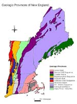
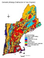
Abstract This geographic information system (GIS) data layer shows the dominant lithology and geochemical, termed lithogeochemical, character of near-surface bedrock in the New England region covering the states of Connecticut, Maine, Massachusetts, New Hampshire, Rhode Island, and Vermont. The bedrock units in the map are generalized into groups based on their lithological composition and, for granites, geochemistry. Geologic provinces are defined as time-stratigraphic groups that share common features of age of formation, geologic setting, tectonic history, and lithology. This data set incorporates data from digital maps of two NAWQA study areas, the New England Coastal Basin (NECB) and the Connecticut, Housatonic, and Thames River Basins (CONN) areas and extends data to cover the states of Connecticut, Maine, Massachusetts, New Hampshire, Rhode Island, and Vermont. The result is a regional dataset for the lithogeochemical characterization of New England (the layer named NE_LITH). Polygons in the final coverage are attributed according to state, drainage area, geologic province, general rock type, lithogeochemical characteristics, and specific bedrock map unit. |
 |
 |
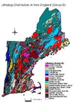 |
| Figure 1. Geologic provinces of New England | Figure 2. General lithology distribution in New England | Figure 3. Lithology distribution in New England (Group B) |
Download the latest version of Adobe Reader, free of charge.
Ordering U.S. Geological Survey products
For questions about the scientific content of this report, contact G.R. Robinson, Jr.
[an error occurred while processing this directive]