High-resolution seismic-reflection surveys in the nearshore of outer Cape Cod, Massachusetts, USGS Open-File Report 03-235
|
Title Page INTRODUCTION Previous Work Geologic Setting Data Acquisition and processing Seismic-Reflection Interpretation Integration with Land-based Stratigraphy Conclusions Acknowledgements References Cited |
Introduction
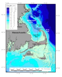
The U.S. Geological Survey (USGS) Woods Hole Field Center (WHFC), in cooperation with the USGS Water Resources Division conducted high-resolution seismic-reflection surveys along the nearshore areas of outer Cape Cod, Massachusetts from Chatham to Provincetown, Massachusetts (Fig. 1). |