High-resolution seismic-reflection surveys in the nearshore of outer Cape Cod, Massachusetts, USGS Open-File Report 03-235
|
Title Page Introduction Previous Work Geologic Setting Data Acquisition and processing Seismic-Reflection Interpretation INTEGRATION WITH LAND-BASED STRATIGRAPHY Conclusions Acknowledgements References Cited |
Integration with Land-based Stratigraphy
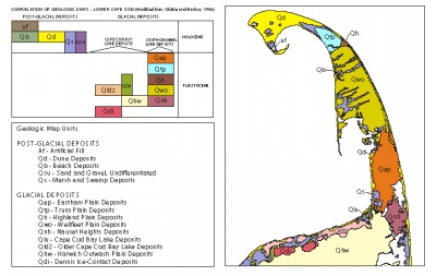
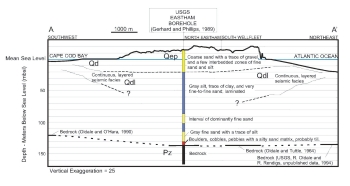
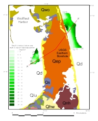
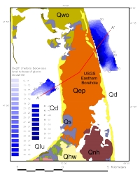
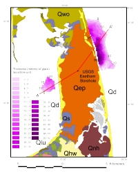
Oldale and O'Hara (1988) integrated the onshore geology (Oldale, 1982) with the offshore stratigraphy of Cape Cod Bay, and there is little new information on the subsurface geology of Outer Cape Cod. However, the USGS drilled two deep boreholes (Fig. 3) that reach bedrock (Gerhard and Phillips, 1989). We have used information from the borehole located in North Eastham to construct a geologic cross section that ties with our seismic interpretation from the nearshore (Fig. 13).
The North Eastham borehole was drilled through glacial deposits to the Paleozoic bedrock surface (Fig. 13). The upper 38.1 m of the core is coarse sand with traces of gravel interbedded with zones of fine sand and silt, and is interpreted to be glaciofluvial outwash. At about 20 mbsl there is a sharp change in lithology to glaciolacustrine-laminated silt with traces of clay and very fine-to-fine sand. This fine-grained unit predominates to about 130 mbsl where there is about 6 m of basal till over the bedrock surface at 136 m below sea level. We believe the glaciolacustrine deposits recovered from this core correlate in part with the well-layered seismic facies mapped in the nearshore in Cape Cod Bay and offshore, east of South Wellfleet and North Eastham (figure 8, figure 9, and figure 10.
| ||||||||||||||||