Open-File Report 03-275
David R. Soller and Marith C. Reheis, compilers
This map, measuring 44 x 41 inches, is presented in PDF format. The Map Unit Description and the Map Discussion are presented as separate Section-508 compliant PDF files. Map, low resolution (100-dpi raster) [13.7-MB PDF file]
|
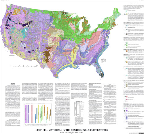
IntroductionThe Earth's bedrock is overlain in many places by a loosely compacted and mostly unconsolidated blanket of sediments in which soils commonly are developed. These sediments generally were eroded from underlying rock, and then were transported and deposited. In places, they exceed 1,000 ft (330 m) in thickness. Where the sediment blanket is absent, bedrock is either exposed or has been weathered to produce a residual soil. This map shows the sediments and the weathered, residual material; for ease of discussion, these are referred to here as "surficial materials." Certain areas on this map include a significant number of rock outcrops, which cannot be shown at the scale of the map; this is noted in the "Description of Map Units" section. Most daily human activities occur on or near the Earth's surface. Homeowners, communities, and governments can make improved decisions about hazard, resource, and environmental issues, when they understand the nature of surficial materials and how they vary from place to place. For example, are the surficial materials upon which a home is built stable enough to resist subsidence or lateral movement during an earthquake? Do these materials support a ground water resource adequate for new homes? Can they adequately filter contaminants and protect buried aquifers both in underlying sediments and in bedrock? Are they suitable for development of a new wetland? Where can we find materials suitable for aggregate? The USGS National Cooperative Geologic Mapping Program (NCGMP) works with the State geological surveys to identify priority areas for mapping of surficial materials (for example, in areas of complex and poorly understood deposits of various sediment types, where metropolitan areas are experiencing rapid growth). To help establish these priorities, a modern, synoptic overview of the geology is needed. This map represents an overview of our current knowledge of the composition and distribution of surficial materials in the conterminous United States. (The map covers only the conterminous U.S. because similar geologic information in digital form was not readily available for Alaska and Hawaii.) The best available map has been a highly generalized depiction at 1:7,500,000-scale (about 120 miles to the inch), prepared for the USGS National Atlas (Hunt, 1979; 1986). This map is compiled at a slightly more detailed scale (about 80 miles to the inch) than Hunt (1979; 1986). We used digital methods, which enabled us to rapidly incorporate the variety of source maps available to us. State-scale geologic maps from the western United States were brought directly into this map, without expending the time needed to resolve interpretive differences among them. Therefore, abrupt changes in surficial materials are indicated along many State boundaries. This of course is an artifact of our compilation technique, and a limitation on its utility. However, this approach supports the basic premise of the map -- to provide an overview of surficial materials, and to identify areas where additional work may be needed in order to resolve scientific issues that can, in turn, lead to improved mapping. |
Suggested citation: Soller, D.R., and Reheis, M.C., compilers, 2004, Surficial materials in the conterminous United States: U.S. Geological Survey Open-file Report 03-275, scale 1:5,000,000.
Document Accessibility: Adobe Systems Incorporated has information about PDFs and the visually impaired. This information provides tools to help make PDF files accessible. These tools convert Adobe PDF documents into HTML or ASCII text, which then can be read by a number of common screen-reading programs that synthesize text as audible speech. In addition, an accessible version of Acrobat Reader 7.0 for Windows (English only), which contains support for screen readers, is available. These tools and the accessible reader may be obtained free from Adobe at Adobe Access.
Get Adobe Reader.

![]() U.S. Department of the Interior |
U.S. Geological Survey
U.S. Department of the Interior |
U.S. Geological Survey
URL: http://pubsdata.usgs.gov/pubs/of/2003/of03-275/index.html
Page Contact Information: Publishing Services
Page Last Modified: Sunday, 13-Jan-2013 00:55:46 EST