|
 |
|
|
 |
| Physical Agents of Land Loss: |
|
| Waves, Currents, & Storm Surges |
 |
|
|
|
|
|
|
|
|
 |
|
|
|
|
|
| Role of Shoreline Characteristics: |
|
|
|
|
|
|
|
|
|
|
| Role of Human Activities: |
|
|
|
|
|
|
|
|
|
|
|
|
|
|
|
|
|
|
|
|
|
|
|
|
|
|
Physical Agents of Land Loss: Waves, Currents, & Storm Surges
Hurricanes (Tropical Cyclones)
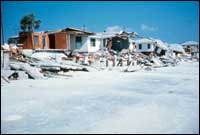 |
| Figure 4b. Powerful storms such as Hurricane Eloise, erode beaches and destroy homes like these near Panama City, Florida that were built too close to the shore. From Morton (1976). [larger version] |
Tropical cyclones, which include tropical storms, Atlantic and Gulf hurricanes, and Pacific typhoons, are relatively small, intense storms that originate near the equator and usually travel from east to west. They form during the summer or early fall when warm seawater and atmospheric circulation favor storm generation (Simpson and Riehl, 1981). Hurricanes are characterized by their four most destructive forces; strong winds including tornadoes, high storm surge and washover (Fig. 5), large waves, and associated rain. The most deadly and destructive storms combine all four forces, but typically one of the forces is dominant. The Saffir-Simpson scale is used to rank hurricanes from 1 to 5 according to their strength and ability to inflict property damage. Category 4 and 5 hurricanes, such as Hurricanes Andrew and Camille, can permanently alter the coastal landscape leaving geological evidence such as erosional escarpments and washover channels that remain long after our memory of the storm has faded.
About 5 to 10 Atlantic and Gulf Coast hurricanes form each year (Riehl, 1979), but most of them do not strike land and their energy is dissipated over the open ocean rather than at the shore. Many of the Atlantic hurricanes travel parallel to or away from the coast. Also, peninsular Florida shields the eastern Gulf of Mexico from westerly moving hurricanes; nevertheless, beach erosion is a chronic problem on the west coast of Florida (Fig. 6).
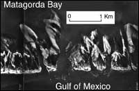 |
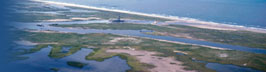
| Figure 5. Hurricane Carla left its permanent mark on Matagorda Peninsula, which is a low-profile barrier island in Texas. The high storm surge, strong waves, and fast currents carved numerous washover channels through the barrier while powerful winds shaped the washover fans causing them to curve in a counterclockwise direction. Photograph provided by the National Ocean Service. [larger version] |
The infrequent occurrence of hurricanes in some coastal areas causes periods of rapid beach erosion and widespread damage followed by calm periods when the beach is relatively stable. This sporadic land loss promotes a false sense of beach stability and safety that has led to high density development and building designs assuring that future storms will set new records in property damage and disaster relief.
In the Gulf of Mexico, a major hurricane causes dramatic land losses and substantial property damage (Fig. 4b) about every 10 years (Hayes, 1967; Nummedal et al., 1980; Morton and Paine, 1985). The greatest natural disaster in U.S. history was the 1900 hurricane that swept across Galveston Island killing nearly 8,000 people and destroying the first two blocks of homes near the ocean. Other memorable Gulf Coast storms were Hurricanes Carla (Fig. 5) and Camille. Hurricane Carla was an intense, slow moving storm that struck Texas in 1961 demolishing a row of dunes 30-50 m wide and cutting numerous washover channels across Padre Island (Hayes, 1967). In 1969 Hurricane Camille went ashore near Bay St. Louis, Mississippi causing an estimated $1.4 billion in property damage. Strong winds and an 8 m storm surge collapsed a 90-unit, two-story brick apartment complex and killed more than 25 people who had sought shelter from the storm. Although this expensive, well-built building was more than 200 m landward of the beach, across a U.S. highway, and "protected" by a seawall, the structure could not withstand the wall of water and high winds that accompanied the storm.
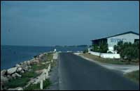 |
| Figure 6. This beachfront motel on the low-energy west Florida coast at Cedar Key has no beach because riprap was placed on the shore to reduce long-term erosion. [larger version] |
As population densities and coastal construction increase, each successive large storm sets records for property damage and destruction. The 1938 New England hurricane was the costliest natural disaster at its time. New York, Connecticut, Rhode Island, and Maine sustained extensive land losses (Nichols and Marston, 1939) and more than $250 million in property damage when the September storm struck during a spring high tide. Hurricane Hugo, a recent category 4 storm, was another costly natural disaster. Although it was a fast moving storm with limited exposure time, Hugo caused economic losses of more than $7 billion in the U.S. alone and more than 15,000 homes were destroyed (Finkl and Pilkey, 1991). Hugo's land loss and destruction were centered on the barrier islands near Charleston, South Carolina. Observations after Hugo and other storms indicate that buildings and access roads contributed to land loss by focusing currents, creating paths for washover, enhancing scour around pilings foundations, and toppling seawalls.
Hurricane Andrew in 1992 was the most destructive storm of record causing more than $15 billion in property damage, mostly as a result of devastating winds. This storm was also unique because it crossed the coast in three places. It first came ashore near Homestead, Florida south of Miami, crossed the west coast of Florida near Naples, and then after traveling northwest it came ashore in southcentral Louisiana. Andrew caused no significant beach erosion in Florida because it was a fast moving storm that crossed the coast at a high angle and had limited fetch to generate large waves. However, Andrew's track in the Gulf of Mexico was nearly parallel to the Louisiana coast for a brief period and it caused more than 30 m of beach erosion and obliterated the dunes on some Louisiana barrier islands.
continue to El Niño Events
|