
|
|
|
|
|
|
|
Physical Agents of Land Loss: Sediment Budget
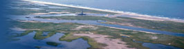
Rivers & DeltasThe amount of river sediment reaching the shore and contributing to the sediment budget varies from one coastal region to another. If the river supplies more sediment than can be redistributed by marine processes, then a delta forms such as the Mississippi Delta. Conversely if the waves and currents can remove more sediment than is being delivered to the shore, then the delta retreats or the sand load is incorporated directly into the beach and a delta is not formed. This is a common occurrence along the Pacific coast where sediment supply is relatively low but wave energy is high. In the U.S., the greatest amount of river-transported sediment is delivered to the Gulf of Mexico (Milliman and Meade, 1983). However, along the Atlantic coast south of Long Island and along most of the Gulf Coast, the sediment transported by rivers is trapped in estuaries and does not reach the ocean shore. Land losses and land gains associated with large deltas, such as the Mississippi, are natural progressive phases in the continuous cycle of delta construction (land gain) and destruction (Wells and Coleman, 1987; Penland et al., 1988). A reduction or termination in sediment supply to one lobe of the delta caused by channel shifting results in widespread land loss as the abandoned delta lobe sinks and is inundated by marine water. The land-gain/land-loss cycle of a Mississippi-type delta begins with breaching of the natural levee along the riverbank. This breach, known as a crevasse, forms a new channel that diverts some of the water and sediment away from the main channel and into an adjacent water body such as a lake or marine embayment. There the sediment is deposited as a new delta lobe that fills the former water body. As the crevasse deepens and widens, more sediment is delivered to the new lobe, which rapidly grows in shallow water. The channel delivery system becomes inefficient the farther the delta builds away from the main channel and eventually the crevasse begins to shoal. Finally the crevasse shoals completely at its entrance, shutting off further sediment supply to the delta. At this time, the new delta lobe enters the latter phase of the sediment budget cycle and begins to deteriorate. Deterioration is manifested as land loss caused mainly by compactional subsidence of the delta lobe, but also partly by wave erosion. |