Link to USGS home page

USGS OFR 03-346
Online only
Version 1.0

Figure 3

figure3

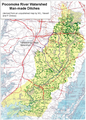
Map showing the distribution and extent of ditching in the Pocomoke basin.

Higher resolution verion of  Figure 3 (470 KB)

U.S. Department of the Interior, U.S. Geological Survey
URL: http://pubs.usgs.gov/of/2003/of03-346/f3.htm
Maintained by Publishing Services
Last modified: 14:38:43 Thu 02 Oct 2003
Privacy statement | General disclaimer | Accessibility