Skip past header information
USGS Banner with link to USGS web page
Coastal and Marine Geology  /  Woods Hole Science Center

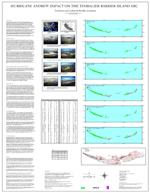
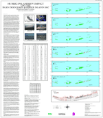
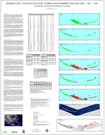
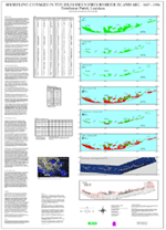
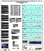
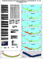
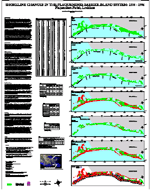
U.S. Geological Survey Open-File Report 03-398

Shoreline Change Posters of the Louisiana Barrier Islands: 1885-1996

Shea Penland1, Chris Zganjar2, Karen A. Westphal2, Paul Connor1, Andrew Beall1, Jeff List3 and S. Jeffress Williams3

The following are shoreline change posters in PDF format* for the Louisiana barrier islands. These posters are the result of a continuing U.S. Geological Survey study being done in collaboration with the University of New Orleans to map shoreline and wetland change and the measure the effects of major storms, like hurricane Andrew in 1992, along the Louisiana coast. The posters are of low-resolution and each section (text, tables and maps) is linked to the full resolution version of that section. For example, clicking on the text section on the left hand side will open the full-resolution of the text. Note: North in all of the posters is to the top.


Adobe Acrobat Reader To view files in PDF format, download free copy of Adobe Acrobat Reader.


Hurricane Andrew Impact on the Timbalier Barrier Island Arc. Hurricane Andrew Impact on the Isles Dernieres Barrier Island Arc. Shoreline Changes in the Timbalier Barrier Island Arc. Shoreline Changes in the Isles Dernieres Barrier Island Arc.
Hurricane Andrew Impact on the Timbalier Barrier Island Arc
Hurricane Andrew Impact on the Isles Dernieres Barrier Island Arc
Shoreline Changes in the Timbalier Barrier Island Arc: 1887-1996
Shoreline Changes in the Isles Dernieres Barrier Island Arc: 1887-1996


Shoreline Changes in the North Chandeleur Island Barrier Arc

Shoreline Changes in the South Chandeleur Island Barrier Arc.

Shoreline Changes in the Caminada-Moreau Headland and Grand Isle.

Shoreline Changes in the Plaquemines Barrier Island System.
Shoreline Changes in the North Chandeleur Island Barrier Arc: 1855-1996
Shoreline Changes in the South Chandeleur Island Barrier Arc: 1869-1996
Shoreline Changes in the Caminada-Moreau Headland and Grand Isle: 1887-1996
Shoreline Changes in the Plaquemines Barrier Island System: 1884-1996


For ease in printing, continuous PDF files are provided below. They contain the text for each poster immediately followed by its corresponding Figures, Maps and Tables.

Hurricane Andrew Impact on the Timbalier Barrier Island Arc (1.6 MB)
Hurricane Andrew Impact on the Isles Dernieres Barrier Island Arc (1.3 MB)
Shoreline Changes in the Timbalier Barrier Island Arc: 1887-1996 (1.2 MB)
Shoreline Changes in the Isles Dernieres Barrier Island Arc: 1887-1996 (1.4 MB)
Shoreline Changes in the North Chandeleur Island Barrier Arc: 1855-1996 (1.8 MB)
Shoreline Changes in the South Chandeleur Island Barrier Arc: 1869-1996 (2.8 MB)
Shoreline Changes in the Caminada-Moreau Headland and Grand Isle: 1887-1996 (1.0 MB)
Shoreline Changes in the Plaquemines Barrier Island System: 1884-1996 (1.2 MB)

*These posters are in PDF format and are not Section 508 compliant.

 
Collaborator Affiliations
University of New Orleans Logo
Louisiana State University Logo
U.S. Geological Survey Logo
1 - Department of Geology and Geophysics
University of New Orleans
2000 Lakeshore Drive
New Orleans, LA 70148
2 - Center for Coastal, Energy and
Environmental Resources

Louisiana State University
Baton Rouge, LA 70803
3 - U.S. Geological Survey
Coastal and Marine Geology
384 Woods Hole Road
Woods Hole, MA 02543-1598
(508) 548-8700

This report is preliminary and has not been reviewed for conformity with U.S. Geological Survey editorial standards (or with the North American Stratigraphic Code). Any use of trade, product, or firm names is for descriptive purposes only and does not imply endorsement by the U.S. government.


Disclaimers and Accessibility
skip footer

[an error occurred while processing this directive]