Digital Mapping Techniques '03
— Workshop Proceedings
U.S. Geological Survey Open-File
Report 03–471
Selection of an Appropriate Base Map for a Statewide Geologic Mapping Program
Illinois State Geological Survey, 615 East Peabody, Champaign, IL 61820
Telephone (217) 244-2513; fax (217) 244-2785; e-mail
domier@isgs.uiuc.edu
Introduction
In 1996, the Illinois State Geological Survey (ISGS) launched an ambitious digital mapping program to characterize geology statewide at the scale of 1:24,000 using the U.S. Geological Survey (USGS) 7.5-minute topographic quadrangle map as the fundamental mapping area. Each of the 1,071 quadrangles that comprise the state eventually will be mapped for bedrock surface, surficial geology, drift thickness and other relevant geologic factors, depending on the area. Historically, the ISGS has utilized film separates from the published versions of USGS 1:24,000-scale topographic quadrangle maps as the primary base for geologic mapping. During the past six years, the ISGS has committed to the use of digital mapping techniques, which requires that digital base map materials be available. We review the current and future large-scale digital map products available from the USGS and identify advantages and disadvantages for their application in the ISGS Geologic Mapping Program.
USGS Digital Raster Graphics (DRG)
Between 1995 and 1998, USGS produced digital raster graphics (DRGs) for some 60,000 USGS quadrangle maps of the U.S. by scanning published paper maps at 250 dots per inch (dpi) resolution. The raster image of each map was georeferenced and fit to the Universal Transverse Mercator (UTM) projection using the datum of the original, published quadrangle map. DRGs are easily imported into GIS software with no additional processing necessary. Map features are symbolized exactly as in the paper map, using standardized symbols and colors to duplicate the line and fill colors of the published map. Most DRGs have higher levels of “color noise” than was originally intended, making it impossible to separate certain features by color in order to remove them (fig. 1). DRGs are available from USGS for $1.00 each, or Illinois DRGs are free for downloading from the ISGS Clearinghouse at http://www.isgs.uiuc.edu/nsdihome/webdocs/drgs/. However, the low resolution and difficulty in removing colors such as green (forested areas) and pink (urban areas) have made DRGs unacceptable as the base for geologic mapping.
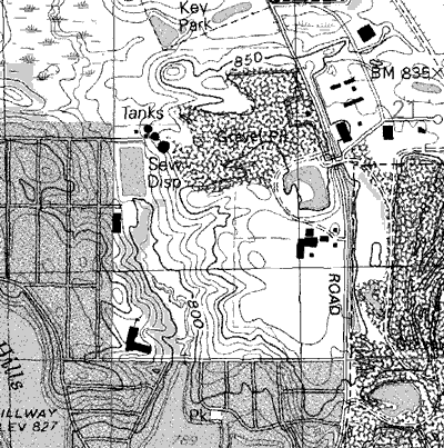 |
Figure 1. USGS original version Digital Raster Graphic (DRG). PRINT this image at actual size. |
Since early 1999, updated DRGs are only created when a USGS topographic quadrangle map is revised and a new edition of the map is published. Topographic maps are revised using all-digital methods by scanning copies of the map”s feature separates at a high resolution, then revising these scans using a digital ortho-photograph and raster editing software. The digital feature separates are used to publish a new revised edition of the paper map. When these digital separates are combined to make a new 500 dpi DRG, they are extremely clean, without the color “noise” that is characteristic of the older DRG files scanned from paper maps.
In October 2001, a revised standard was implemented by the USGS for a new-version DRG product, with a resolution of 500 dpi and a color palette of up to 256 colors. Only about 1,000 DRGs per year are produced at this resolution. These revised standard DRGs are created when revisions are made to a quadrangle map, but there is no program or funding for systematic updating of the current DRGs to the new standard.
USGS DIGITAL LINE GRAPHS (DLG)
Over the past 20+ years, the USGS has produced digital line graph (DLG) files. DLGs are digital vector representations of topographic and planimetric map features derived from either aerial photographs or from cartographic source materials, using manual and automated digitizing methods. Large-scale (1:24,000) DLG data primarily are derived from USGS 7.5-minute topographic quadrangle maps. These data files contain selected base categories of cartographic data including:
Separate feature layers allow for selection or omission of map features, and the vector data provides high quality line work for publication of geological maps (fig. 2). A good knowledge of GIS software is required for processing DLG files. The raw files must be converted to a format compatible with GIS software, and then each feature type must be symbolized to recreate the appearance of the original topographic quadrangle map.
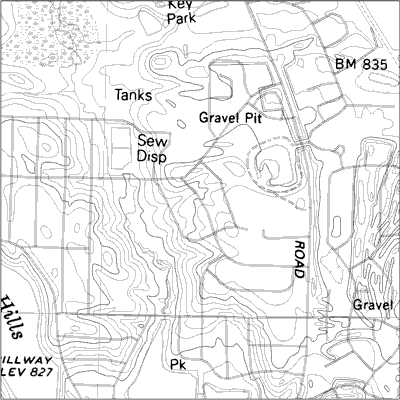 |
Figure 2. Digital Line Graph(DLG) with raster text scanned from mylar separate. PRINT this image at actual size. |
In the state of Illinois, the availability of DLG data files is limited (fig. 3). In fact, the majority of Illinois 7.5-minute quadrangle maps have no DLGs at all, while a minority has some or all of the DLG feature layers available. Existing DLGs are free for downloading from USGS or can be ordered for $1.00 per quadrangle. New DLGs can be created by USGS for a much greater cost. In the past ISGS has ordered updates of four basic feature layers (hypsography, hydrography, transportation and PLSS) for approximately $7,415.00 per quadrangle. Because the DLGs do not include cartographic text, the mylar source materials for the cartographic text were also purchased, at $60.00 per mylar, (mylar map separates are no longer available from USGS, as of August 1st, 2003.) Given limited budget resources for base maps, ISGS has only been able to obtain the basic DLG feature files for 3 or 4 quadrangles per year.
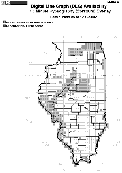 |
 |
| Figure 3. Availability of two USGS DLG feature layers for Illinois | |
RASTER FEATURE SEPARATES (RFS) AND RASTER COLOR COMPOSITES (RCC)
At the time of original compilation of the 7.5-minute quadrangle maps (approximately 1945 to 1990), mylar materials were used for the production of the printed maps. All the features on one mylar separate were of the same color, but all features of the same color were not always on one separate. One quadrangle may have 5 to 20 mylar feature separates, depending on the time period it was made and the production guidelines during that time.
In the late 1980s, digital drafting tools began to replace scribing in the map revision process. Mylar separates are now scanned at 1000 dpi or greater, and the resulting raster feature separates are updated using raster revision methods. These digital raster feature separates (RFS) can be combined to make negatives for printing a new map, or to create raster color composites (RCC) which contain all of the RFS layers in one color file. These RCC files are used for the creation of “new standard” DRG files.
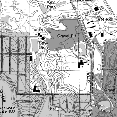 |
Figure 4. Raster Color Composite(RCC). PRINT this image at actual size. |
Nearly all USGS feature separates are available only on mylar. Raster feature separates can be made directly from the mylar separates, without any revision. In this case the RFS and RCC files will be identical to the most current published edition of the paper map. This process is still undergoing formal standards review at the USGS, and RFS products are currently produced as a full-repay joint funding agreement with the USGS.
RFS products include both 1000 dpi and 500 dpi RFS and RCC files. Cost for one quadrangle may range between $700 and $1,200, depending on the number of map separates. These files are geo-referenced and easily used in GIS systems with no additional processing.
SUMMARY OF BASE MAP ADVANTAGES AND DISADVANTAGES
Digital Raster Graphics (DRG):
Digital Line Graphs (DLG)
USGS Raster Feature Separates (RFS) and Raster Color Composites (RCC)
BASE MAPS FOR THE ILLINOIS STATE GEOLOGICAL SURVEY
In 1996, at the inception of a new geologic mapping project, the geologists and GIS specialists at ISGS began developing standardized methods for producing digital geologic maps. During this time, the original-format 250 dpi USGS DRG files became available for the state of Illinois and were quickly adopted by the geologists for compiling geologic features in a GIS.
Eventually, when a map was ready for printing, the DRG was used as the base map. With only 250 dpi resolution, DRG files did not provide a sufficiently clean and clear image. Additionally, the color tints for urbanized and wooded areas could not be removed because of the combination of colors used to make each feature type. These color tint areas conflicted with the colored areas of geologic surfaces, making the map difficult to interpret.
During the same period of time, geologists at the ISGS used DLG files for the base for printing geologic maps. The original DLG files must first be converted to a format compatible with the GIS software. GIS specialists at ISGS converted the files, and created symbolization codes for dozens of feature types in the DLG layers. Symbols to match the USGS 7.5-minute topographic quadrangle maps were developed using Arc/Info.
Additionally, very few of the features in DLG files have label attributes, so that labels for roads and other features must be placed by hand. In order to avoid that time-consuming process, mylar separates of the map text were ordered from USGS, then scanned to produce a raster text layer for the map. This text usually did not include red, blue or brown text, which still needed to be hand-placed on the map.
Often, DLGs were not available for quadrangles or were in need of revision, especially in rapidly urbanizing areas where geologic mapping was prioritized. Hence, the acquisition of DLG base files was expensive and required a significant time commitment from GIS specialists and graphics personnel before the base map was ready for printing.
Early in 2002, several RFS and RCC products were created for a project in northern Illinois. After careful consideration of these raster files, ISGS decided to use these products for publication of geologic maps in 2003. The cost is much lower (approximately $1,000 per quadrangle), so it was possible to order 20 RFS base maps with annual basemap funding. The hope is that ISGS will be able to publish geologic maps more quickly with less processing time required for the RFS files, while benefiting from the high quality of the RFS basemaps.
RELATED INFORMATION
Domier, J. E., 2003, Retiring of the USGS map separates and the emergence of the USGS raster feature separates: presentation at Illinois Mapping Advisory Council meeting, November 28, 2003, Springfield, Illinois. (http://ngmdb.usgs.gov/Info/dmt/docs/domier03.html).
REFERENCES
USGS web site, Digital Raster Graphics (http://topomaps.usgs.gov/drg/), and Digital LineGraphs, (http://edc.usgs.gov/products/map/dlg.html).
USGS Standards for Raster Feature Separates, (http://rockyweb.cr.usgs.gov/nmpstds/rfsstds.html).