ENVIRONMENTS
(major environments only)
Digital Mapping Techniques '03
— Workshop Proceedings
U.S. Geological Survey Open-File
Report 03–471
Science Language for Geologic-Map Databases in North America: A Progress Report
ABSTRACT
A standardized language to classify and describe earth materials and their genesis is needed because producers and consumers of geoscience information use names, terms, and icons to communicate information about geologic objects and concepts. To the extent possible in a world of words, standardized terminology is useful to facilitate information exchange.
The Science Language Technical Team of the North American Data Model Steering Committee is a multi-constituency group of geologic-map producers and geologic-map users that, during the period April 2000 to November, 2003, has developed a prototype science-language for the naming and describing of earth materials in geologic-map databases produced by public-sector entities in North America. The classification adopts the following high-level architecture:
Earth material
Igneous material
Hypabyssal rock
Plutonic rock
Plutonic
Hypabyssal
Volcanic rock
Intrusive
Effusive
Volcaniclastic
Composite-genesis material
Metamorphic rock (traditional sense)
Cataclastic rock
Impact-metamorphic material
Sedimentary material
Unconsolidated sedimentary material
Consolidated sedimentary material
These high-level categories fundamentally are genetic: they reflect how the earth material was formed (genetic process, crustal depth). This raises the irony that, although deeper levels of the classification hierarchies are based mainly on what the mapping geologist can see in the outcrop, traditional high-level classification approaches are compound, and link genesis with empirical composition and texture. Lower-level material names descending from each high-level category generally are based on singular textural or compositional criteria, depending on the parental category.
The use of standardized science language in digital geologic-map databases is a new frontier that is likely to evolve with time and experience. With this in mind, we are developing classifications of earth materials that we believe reflect not only how mapping geologists view them but also how such materials might be queried and analyzed in geologic-map databases. No single classification of earth materials will please all workers. However, the schemes we propose hopefully will be clearly understandable, internally consistent, and usable by both data-producer and data-user.
1 INTRODUCTION
1.1 Background
With the increasingly widespread production and use of digital geologic-map databases it has become clear that, to more effectively serve their constituencies, geoscience agencies need to develop several vital pieces of digital infrastructure:
To attain these objectives, public-sector geologic-mapping entities in the United States and Canada formed a partnership called the North American Data Model Steering Committee (NADMSC, http://geology.usgs.gov/dm/steering). This informal group is sponsored by cooperative agreements between the U.S. Geological Survey (USGS) and the Association of American State Geologists (AASG), and between USGS and the Geological Survey of Canada (GSC). Through the former, NADMSC is linked to the database and standards-development activities of the National Geologic Map Database; through the latter, NADMSC is linked to database-development activities ongoing in Canada under the auspices of the Canadian Geoscience Knowledge Network.
The NADMSC first met early in 1999 to chart a strategy for developing various aspects of a standard geologic-map data model. Identified as a critical activity was the need for standardized science language for use in North America. To meet this task, NADMSC chartered a Science Language Technical Team (SLTT, http://geology.usgs.gov/dm/steering/science.html) that first convened in early 2000. SLTT members were identified in the following ways:
The assembled group (Table 1.1.1) represents a cross section of public-sector geologic-map producers and map users in the United States and Canada.
| Table 1.1.1 NADMSC Science Language Technical Team committee members (Jonathan C. Matti, Committee chair) | ||
| Participant
|
Affiliation
|
SLTT Role
|
|---|---|---|
| Lee Allison | Kansas Geological Survey | General scientific overview |
| Brian Berdusco | Ontario Geological Survey | General scientific overview |
| Thomas M. Berg | Ohio Geological Survey | General scientific overview |
| Sam Boggs, Jr. | University of Oregon | Sedimentary Subgroup |
| Eric Boisvert | Geological Survey of Canada | Sedimentary Subgroup |
| Andrée M. Bolduc | Geological Survey of Canada | Sedimentary Subgroup (co-chair) |
| Mark W. Bultman | U.S. Geological Survey | Sedimentary Subgroup |
| William F. Cannon | U.S. Geological Survey | Metamorphic Subgroup |
| Robert L. Christiansen | U.S. Geological Survey | Volcanic Subgroup (co-chair) |
| Jane Ciener | U.S. Geological Survey | Geologic-map editorial standards |
| Stephen P. Colman-Sadd | Geological Survey of Newfoundland and Labrador | Metamorphic Subgroup |
| Peter Davenport | Geological Survey of Canada | General scientific overview |
| Ron DiLabio | Geological Survey of Canada | Sedimentary Subgroup (co-chair) |
| Lucy E. Edwards | U.S. Geological Survey | Sedimentary Subgroup |
| Robert Fakundiny | New York State Geological Survey | General scientific overview |
| Kathleen M. Farrell | North Carolina Geological Survey | Sedimentary Subgroup |
| Claudia C. Faunt | U.S. Geological Survey | Volcanic and Sedimentary Subgroup |
| Mimi R. Garstang | Missouri Department of Natural Resources | General scientific overview |
| Joe Gregson | National Park Service | General scientific overview |
| Thomas D. Hoisch | Northern Arizona University | Metamorphic Subgroup |
| J. Wright Horton, Jr. | U.S. Geological Survey | Metamorphic Subgroup (co-chair) |
| David W. Houseknecht | U.S. Geological Survey | Sedimentary Subgroup |
| Bruce R. Johnson | U.S. Geological Survey | Volcanic and Metamorphic Subgroup |
| Robert Jordan | Delaware Geological Survey | General scientific overview |
| Ronald Kistlers | U.S. Geological Survey | Plutonic Subgroup (co-chair) |
| Alison Klingbyle | Geological Survey of Canada | Geologic-map editorial standards |
| Dennis R. Kolata | Illinois Geological Survey | Sedimentary Subgroup |
| Elizabeth D. Koozmin | U.S. Geological Survey | Geologic-map editorial standards |
| Hannan LaGarry | Natural Resources Conservation Service | Sedimentary Subgroup |
| Diane E. Lanep | U.S. Geological Survey | Geologic-map editorial standards |
| Victoria E. Langenheim | U.S. Geological Survey | Plutonic and Sedimentary Subgroups |
| Reed Lewis | Idaho Geological Survey | Plutonic and Volcanic Subgroups |
| Stephen D. Ludington | U.S. Geological Survey | Volcanic Subgroup (co-chair) |
| Jonathan C. Matti | U.S. Geological Survey | Sedimentary Subgroup (co-chair) |
| James McDonald | Ohio Geological Survey | Sedimentary Subgroup |
| David M. Mille | U.S. Geological Survey | Sedimentary Subgroup (co-chair) |
| Andrew Moore | Geological Survey of Canada | Sedimentary Subgroup |
| Douglas M. Morton | U.S. Geological Survey | Plutonic Subgroup (co-chair) |
| Patrick Mulvany | Missouri Department of Natural Resources | General scientific overview |
| Carolyn G. Olson | Natural Resources Conservation Service | Sedimentary Subgroup (co-chair) |
| Anne R. Poole | National Park Service | Plutonic and Sedimentary Subgroups |
| Stephen M. Richard | Arizona Geological Survey | Metamorphic Subgroup (co-chair) |
| Andrew H. Rorick | U.S. Forest Service | Sedimentary Subgroup |
| William Shilts | Illinois State Geological Survey | General scientific overview |
| David R. Soller | U.S. Geological Survey | Sedimentary Subgroup (co-chair) |
| Roy Sonenshein | U.S. Geological Survey | Sedimentary Subgroup |
| William C. Steinkampf | U.S. Geological Survey | Volcanic and Sedimentary Subgroups |
| Douglas B. Stoeser | U.S. Geological Survey | Plutonic Subgroup |
| Lambertus C. Struik | Geological Survey of Canada | General scientific overview |
| John Sutter | U.S. Geological Survey | General scientific overview |
| Harvey Thorleifson | Minnesota State Geological Survey | Sedimentary Subgroup |
| Robert J. Tracy | Virginia Polytechnic Institute and State University | Metamorphic Subgroup |
| David Wagner | California Geological Survey | Volcanic Subgroup |
| Richard B. Waitt | U.S. Geological Survey | Sedimentary Subgroup |
| Peter D. Warwick | U.S. Geological Survey | Sedimentary Subgroup |
| Richard Watson | U.S. Bureau of Land Management | General scientific overview |
| Gerald A Weisenfluh | Kentucky Geological Survey | Sedimentary Subgroup (co-chair) |
| Carl M. Wentworth | U.S. Geological Survey | Sedimentary Subgroup |
| Michael L. Williams | University of Massachusetts | Metamorphic Subgroup |
| Ric H. Wilson | U.S. Geological Survey | Volcanic and Plutonic Subgroup |
| Robert P. Wintsch | University of Indiana | Metamorphic Subgroup |
| Michael L. Zientek | U.S. Geological Survey | Plutonic and Metamorphic Subgroups |
1.2 Related science-language efforts
SLTT activities benefited from a series of International Union of Geological Sciences (IUGS) sub-commissions chartered to develop uniform classifications of earth materials:
The International Union for Quaternary Research [INQUA] in the 1970’s sponsored a Commission on Genesis and Lithology of Glacial Quaternary Deposits (Commission C-2). The results of Commission C-2 were published in Goldthwait and Matsch (1988; see Commission summaries in Goldthwaite and others, 1988, p. vii–ix, and Dreimanis, 1988, p. 19–25). The SLTT used this document to develop science language for sedimentary materials of glacial origin.
In a precedent-setting effort, in 1999 the British Geological Survey (BGS) issued four reports (Hallsworth and Knox, 1999; McMillan and Powell, 1999; Gillespie and Styles, 1999; Robertson, 1999) that presented science language for earth materials from a geologic-mapping point of view. The SLTT used these four reports as a starting point for our deliberations. The SLTT adopted major elements of the BGS approach, but found that in order to accommodate North American geologic-mapping traditions and approaches we had to develop slightly modified terminology and taxonomic hierarchies.
Within the United States, an important science-language activity is occurring under auspices of the Federal Geographic Data Committee (FGDC) Geologic Data Subcommittee (http://ncgmp.usgs.gov/fgdc_gds/). The FGDC has developed a draft cartographic standard for polygon, line, and point symbols that depict geologic features on geologic maps and digital displays. Although primarily concerned with cartographic technical specifications, the FGDC cartographic standard contains science-language concepts that ultimately must be integrated with and enlarged upon by the NADMSC SLTT group.
1.3 SLTT Housekeeping
SLTT has conducted its activities without dedicated salary and without a dedicated travel budget. As a result, face-to-face meetings generally were not possible, and SLTT members have boot-legged time from their agency science projects at the expense of project deliverables. The majority of SLTT interactions have been in the form of email discussions and conference calls. Both internal and external evaluation of science-language concepts was facilitated by a web-conference site that stimulated discussion of philosophical and operational issues (see http://geology.usgs.gov/dm/terms/).
Appendix 1 reprints the SLTT charter developed by NADMSC in 1999. Appendix 2 archives memoranda issued by the SLTT chair (J.C. Matti) discussing background issues and outlining guidelines for SLTT activities. These guidelines established the tone for Subgroup deliberations during the period April, 2000 through November, 2003.
Early on, SLTT decided to split into subgroups organized around major classes of earth material:
Ultimately, SLTT recommended to NADMSC that the surficial and sedimentary subgroups merge into a single group, based on three factors: (1) unconsolidated surficial materials are sedimentary in origin; (2) the lithology, physical properties, genesis, and geomorphology of sedimentary and surficial materials are identical; and (3) scientific perspectives\and geologic-mapping experience in the two subgroups complemented each other and provided insights beneficial to both groups. NADMSC sanctioned this recommendation, and the combined sedimentary and surficial subgroups have worked together to develop a single body of science language for unconsolidated and consolidated sedimentary materials.
The SLTT chair selected subgroup co-chairs based on the following criteria: geologic-mapping experience, expertise in their science field, and knowledge of their agency’s role in producing or using geologic-map databases. Subgroup co-chairs reflect a range of American and Canadian constituencies and Federal and State perspectives.
1.4 SLTT activities
20-queries exercise—SLTT’s first order of business tasked each committee member to submit twenty queries to a hypothetical geologic-map database. This exercise had two purposes;
Results of the 20-queries exercise revealed that database-users were interested in a broad range of geologic concepts and database targets—ranging from (1) academic queries related to the lithology, genesis, geometry, and age of geologic materials and structures to (2) pragmatic queries targeting what information geologic-map units and geologic structures contain about natural resources, fluid transmissivity (ground water and hydrocarbons), geologic hazards (swelling ground, landslides, earthquake-induced ground-shaking), and land-use planning (landfill siting, ground-water recharge, commercial and residential development, infrastructure siting). The SLTT’s task was to develop science language to facilitate this broad range of potential database queries. Visit http://geology.usgs.gov/dm/steering/teams/design/background.shtml to examine the kinds of subjects reflected by the 20-queries experiment.
Results of the 20-queries exercise were passed along to the NADMSC Data Model Design Team (DMDT) for analysis and (especially) to ensure that science concepts emerging from the SLTT process were considered by DMDT as it developed architecture for a standard geologic-map data model.
Iterative science-language development—Using the 20-queries exercise and building upon the four BGS classification documents, the SLTT subgroups iteratively developed science-language schemes that were exchanged by email among subgroup members. This process continued from about September, 2000 through March, 2003.
Internal SLTT review—After each subgroup completed a consensus classification of earth materials, subgroup documents were submitted for SLTT-wide peer review. This review was intended to ensure uniformity of philosophical and operational approach throughout the SLTT science-language process.
NADMSC review—Following internal SLTT-wide peer review, SLTT science language documents were forwarded to the NADMSC for evaluation and review for consistency, for geopolitical sensitivity, and for compatibility with the data-model architecture being developed by the DMDT.
Community-wide peer review—Following NADMSC approval, the SLTT documents are under final revision and will be released on a website for broad peer review from the North American geologic-mapping community.
1.5 Who prepared this report?
The SLTT chair (Matti) prepared this report in coordination with SLTT subgroup leaders (Table 1.5.1), each of whom contributed to the narratives in Section 3.
| Table 1.5.1 SLTT Subgroup leaders who contributed to this report | ||
|
Andrée M. Bolduc
|
Geological Survey of Canada
|
Sedimentary Subgroup
|
|
Robert L. Christiansen
|
U.S. Geological Survey
|
Volcanic Subgroup
|
|
Ron DiLabio
|
Geological Survey of Canada
|
Sedimentary Subgroup
|
|
J. Wright Horton, Jr.
|
U.S. Geological Survey
|
Metamorphic Subgroup
|
|
Ronald W. Kistler
|
U.S. Geological Survey
|
Plutonic Subgroup
|
|
Stephen D. Ludington
|
U.S. Geological Survey
|
Volcanic Subgroup
|
|
Jonathan C. Matti
|
U.S. Geological Survey
|
Sedimentary Subgroup
|
|
David M. Miller
|
U.S. Geological Survey
|
Sedimentary Subgroup
|
|
Douglas M. Morton
|
U.S. Geological Survey
|
Plutonic Subgroup
|
|
Carolyn G. Olson
|
Natural Resources Conservation Service
|
Sedimentary Subgroup
|
|
Stephen M. Richard
|
Arizona Geological Survey
|
Metamorphic Subgroup
|
|
David R. Soller
|
U.S. Geological Survey
|
Sedimentary Subgroup
|
|
Gerald A Weisenfluh
|
Kentucky Geological Survey
|
Sedimentary Subgroup
|
2 PHILOSOPHICAL AND OPERATIONAL APPROACH
2.1 Purpose
The SLTT purpose is to develop a science-language standard2 for the description, classification, and interpretation of earth materials in geologic-map databases. The language should provide a logical, consistent, hierarchical framework for naming and classifying earth materials, and for describing their physical characteristics and genesis—based on the way geologic maps are made by the field geologist or assembled by a science compiler (Section 2.6.2).
2.2 Intended Use
Science language under development by the SLTT is intended for use by persons and agencies that submit digital geologic-map data into public-domain databases managed by various State/Provincial and Federal agencies. We are not setting standards for use by academia or by the private sector, unless these entities contribute geologic-map products to public databases.
Intended users include:
2.3 Legacy data versus future data
The body of North American geologic-map information has two components: (1) “legacy data” archived in paper maps and digital files as the result of historic geologic mapping, and (2) new data that will be developed through future geologic-mapping. Incorporation of these two kinds of data sets into geologic-map databases involves different kinds of strategies, each posing its own challenge to science language.
North American legacy geologic maps are rich in geologic terminology. Typically, such data are contained either in map-marginal descriptions of map units or in pamphlets and reports that accompany the geologic map. Unfortunately, legacy maps rarely cite the classification systems used by the map maker to name and describe earth materials. Consequently, it is left to the map user to interpret the meaning and usage of terminology. For high-level terms (e.g., sedimentary rock, terrigenous-clastic sediment, plutonic rock, metamorphic rock, volcanic rock) the meaning may be universally understood. However, for deeper-level terms (e.g., shale, mud, basalt, quartz latite, quartz monzonite, granodiorite, volcaniclastic, slate, lahar, greenstone, gneiss, layered gneiss) the meaning may not be clear because many terms have inconsistent usage depending on when and where the map maker learned his or her craft. As a result, the map user commonly must interpret the meaning of earth-material terms according to his or her own experience.
This problem is compounded by two factors:
As a group, the SLTT committee had to wrestle with these issues, and decide on whether our science-language approach (1) should attempt to accommodate historical usage that is diverse, inconsistent, and in some cases generic, or (2) should reflect the needs and requirements of future geologic-map makers for science language that is stable and consistent. Ideally, any such decision will reflect the policy of the database developer, which usually means the management policy of the geologic-mapping agency or entity. With respect to legacy information, two contrasting data-management choices apply:
The SLTT group is not mandated to make such a policy decision on behalf of its constituent agencies. However, we recognize that legacy geologic maps include a wide variety of earth-material terms, many of which have similar, if not identical, meanings. Our purpose was to review how such terms have been used historically, and to judge how useful they are for storage, manipulation, retrieval, and analysis in geologic-map databases. In most instances, we found that traditional earth-material nomenclature lends itself well to database applications. However, we found that some traditional names and classification schemes did not adapt themselves easily to database requirements. In such instances, we had to modify existing names slightly, abandon some terms, or propose new names. The result is a hierarchical classification of earth materials that accommodates two objectives:
2.4 Operational Approach
The question of “What’s in a name?” has plagued taxonomic classifications in all scientific arenas.
Historically, people have coined names for objects or concepts in order to convey information about them. The names are shorthand expressions (representations or proxies) for information packets that can be quite complex. Traditionally, the human brain has done the job of identifying all the attributes and components represented by a name. Now, we are asking computer databases to do this job.
The challenge to geologic classification and description in the database environment is:
The prototype SLTT classifications lean toward the second approach. Each hierarchical level in the proposed classifications is designed to contain names or terms that represent geologic concepts that are as narrowly defined as possible. In general, we tried to avoid names or terms that represent complex combinations of geologic information. Instead, we strived to break these combinations down into individual attributes (descriptors) that are not used as part of the lithologic name but instead are relegated to other database fields.
This approach does not deny that most high-level terms, by their very nature, already are compound and complex. However, for deeper-level geologic names we tried to minimize their compound nature.
2.5 Definition of Concepts
The SLTT documents use certain concepts and terms (e.g., classify, name, define, describe) that have common generic meanings. For our purposes, these terms need to be delineated without ambiguity. The following definitions guided our deliberations:
Characterize—“v.t. 1. to mark or distinguish as a characteristic; be a characteristic of....2. to describe the character or individual quality of....3. to attribute character to....” (Webster’s Encyclopedic Unabridged Dictionary of the English Language, 2001, p. 347).
Controlled term—A term or name whose meaning and scope is restrained or restricted so that the term can be used or applied only according to the definition contained in a standard.
Classify—“v.t. 1. to arrange or organize by classes; order according to class. 2. to assign a classification to (information, a document, etc)” (Webster’s Encyclopedic Unabridged Dictionary of the English Language, 2001, p. 381). To classify is to assign an instance to a specific group defined on the basis of a set of properties shared by members of the group. To classify answers the question “what kind of X is instance Y?”, where X represents the domain of the classification.
Define—“ v.t. 1. to state or set forth the meaning of....2. to explain or identify the nature or essential qualities of....3. to fix or lay down definitely; specify distinctly....4. to determine or fix the boundaries or extent of....5. to make clear the outline or form of....” (Webster’s Encyclopedic Unabridged Dictionary of the English Language, 2001, p. 523).
Description—A set of statements that characterize the nature of a thing (a class or instance) such that the thing may be identified and named.
Earth material—A naturally occurring substance formed in or on the Earth by physical, chemical, or biogenic processes that produce solid particles or crystals of mineral and (or) rock.
Instance—“n. 1. a case or occurrence of anything....” (Webster’s Encyclopedic Unabridged Dictionary of the English Language, 2001, p. 988).
Geologic-map unit—An intellectual construct that a geologist delineates on a map as a way to communicate a geologic concept to the map user. Each geologic-map unit corresponds to a three-dimensional volume of earth material that consists of one or more discrete lithotopes whose character and (or) frequency of occurrence makes each map unit distinct and unique from other such units. The map maker defines the scope, scale, boundaries, names, and reference sections for geologic-map units according to rules developed and adjudicated by the North American Commission on Stratigraphic Nomenclature (NACSN, 1983).
Lithotope—A body of sediment or rock that can be “a stratigraphic unit, a part of a stratigraphic section, a particular kind of sediment or rock, [or] a body of uniform sediments formed by the persistence of the depositional environment” (Glossary of Geology, Jackson, 1997, p. 373).
Modifier—A term or word that limits, constrains, or qualifies a controlled term.
Name—“n. 1. a word or a combination of words by which a person, place, or thing, a body or class, or any object of thought is designated, called, or known....” (Webster’s Encyclopedic Unabridged Dictionary of the English Language, 2001, p. 1276). By this definition, a name is a proxy for the complete description that defines the nature of something (e.g., an “instance” of a geologic map unit). Ideally, every instance would have a unique name, but of course in the realm of earth materials, this is not always the case. That is why SLTT attempts to provide a standardized classification of names for earth materials, their physical attributes, and their genesis.
2.6 Guidelines followed by SLTT
In developing science language for earth materials, SLTT adopted the following rules:
2.6.1 Descriptive classification basis
To produce a classification system for earth materials that allows different observers to classify a given sample in the same way, the system must be based on physical properties of the rock recognizable by all observers. The properties used for field classification of earth materials include modal mineralogy, grain size, grain shape, rock fabric (the arrangement of grains in an aggregate to form the rock), and structures in the rock (bedding, layering, etc.). Although distinct bodies of rock may be recognized based on other physical properties (e.g., magnetic susceptibility, or density), these generally are not used as field criteria.
The approach to a lithologic classification developed here is fundamentally descriptive—that is, classification of an earth material is based on its observable features, and its assignment to a lithologic class implies that certain descriptive criteria are met. These descriptive criteria provide default attributes for each earth material, and no other attributes are required to satisfy the material definition. For example, the name for a sedimentary material (e.g., sandstone, calcareous dolostone, slightly gravelly sand) is a proxy for a default description embedded in the database simply through application of name to the material.
2.6.2 Science language compatible with geologic-mapping strategies
The goals and methods of geologic mapping require science-language structures that are different from those of other endeavors. This is because the types of observation that go into developing a geologic-map database do not have the same information content and scientific credibility at all locations within the map footprint. This conclusion is based on the nature of the geologic-mapping process.
For each geologic map, the scope, scale, and consistency of geologic observation varies throughout the map footprint. This is because the nature and quality of each observation varies from place to place, depending on its purpose, the time available to make it, and the quality of the geologic outcrop. Many observations upon which the map is based are detailed and comprehensive; others are generalized and cursory. The latter typically are not the fault of the geologic-map maker, but rather are intrinsic to the geologic-mapping process itself: every potential observation point within the map footprint cannot be examined with the same level of definitive care and quality, and the information content within a geologic-map unit must be extrapolated between observation points—some of which may be quite far apart.
The preceding examples suggest that a hierarchical observational approach characterizes the geologic-mapping process—ranging from generalized observations that are reconnaissance in scope to detailed observations that are definitive in scope. Each observational style has its own confidence level. Moreover, science-language terms for each observational level have slightly different meanings depending on the scale of observation. In each of the preceding examples, (1) does the term “sandstone” have the same meaning? (2) Are different types of information communicated through the use of “sandstone” in each circumstance? We answer “no” to the first question and “yes” to the second. This is a different process than takes place in the controlled environment of a petrology laboratory, where specific kinds of questions are pursued systematically and answered using language that is definitive and precise. Accordingly, we conclude that the science language of earth materials in geologic-map databases must be structured to reflect the hierarchical nature of observations made during the geologic-mapping process.
This is not to say that the observational quality of geologic-map information is poor—in specified places it is quite good. However, developers and users of science language for geologic maps need to be aware that (1) not all observations have the same level of refinement and (2) information projected (extrapolated) outward away from observation points without benefit of intervening data—the essence of geologic-map making—is vulnerable. These limitations require the science language of geologic-map data sets to be constructed so that the language reflects how geologic mapping actually is executed.
2.6.3 Progressive Hierarchical Structure
The classification language should be progressive: that is, it should be based on what the geologist can observe and describe sequentially during the course of making a geologic map—first with the un-aided eye, then with hand lens, and then with thin section. Each of these observation classes yields a package of information that differs in scope, content, and rigor from that in other classes. Lithologic names should be developed that are consistent with each observational class.
The progressive nature of the observation process yields a hierarchical language structure—that is, language that begins at a generalized level and progressively has more specific categories that communicate more refined information about each earth material. This hierarchical structure must rigidly follow the rules of parent-child lineages—that is, each child should occur only once in the hierarchy, and should have only one parent. This is important because compound parentage (where a geologic object can have more than one parent—i.e., can be interpreted as the result of more than one process) makes the classification process difficult and can lead to misleading hits during database queries and analysis.
Developing a logical hierarchical structure proved to be vexing. As with Linnean zoological taxonomy, the purpose of organizing earth-material names into parent-child lineages is to identify logical relationships among individual lithologic types and groups of lithologic types; taxonomic names presumably should reflect these relationships. In the case of geologic-map databases, the premise is that lumping and splitting real-world objects into inter-related categories will help in analyzing the objects, and will facilitate searching the geologic-map data set for items as narrowly or broadly defined as our interests require. We assume this premise is a valuable one, and that a hierarchical classification approach is not just a clerical device but has functional utility.
2.6.4 Clarity and Ease of Use
The data-producer and the data-user must understand clearly the basis for the earth-material classification schemes, and must be able to use them easily and comfortably. In some cases, proposed SLTT language structures require the map maker and map user to re-think or re-learn how to use some terms. However, in general, we predict that our language structures will be familiar to most users, and will provide a systematic and uniform way to describe and interpret earth materials.
2.6.5 Robust yet Flexible
As the SLTT group discussed the philosophy and rules of science language for geologic-map databases, we came to understand that such language needs to accommodate tensions that exist between two competing requirements: (1) the need to be rigorous and robust, and (2) the need to allow the geologic-map maker to uniquely describe and interpret earth materials that occur within the map area. This tension boils down to the battle between robustness and flexibility:
| Table 2.6.5.1 Rules and procedures for building “local favorites list” | ||||
|
Local term
|
Local meaning
|
SLTT concept
|
SLTT concept
|
SLTT concept
|
|---|---|---|---|---|
| black shale | Fissile claystone containing abundant organic matter | grain size (specify clay:silt:sand ratio) |
depositional fabric (specify fissile fabric) |
composition (specify amount and type of organic content) |
| greenstone | Lower-greenschist facies mafic to intermediate rock | Metamorphic facies | fabric (specify fabric) |
composition (specify composition) |
| mangerite | A charnockitic plutonic rock equivalent to an orthopyroxene-bearing monzonite | modal mineralogy (specify pyroxene modal percent) |
family (specify monzonite) |
genesis (specify plutonic igneous) |
The only catch to this flexibility is that lithology terms in a “local favorites list” must be formally defined using science concepts and language laid out in the SLTT standard, and using data fields equivalent to those defined in the NADM data-model standard.
2.6.6 Compliance with North American Traditions
Earth-material names and parent-child relations among them must make sense according to common North American practice.
2.6.7 Rock Names versus Modifiers
Classification schema must distinguish clearly between defined earth-material names versus modifiers that add information to each name. Distinctions between names and modifiers should be incorporated into the architecture of the data fields and relational tables that support geologic-map databases, rather than into the rock names themselves.
2.7 Does genesis play a role in Earth-material classification?
In general, SLTT does not use genesis as a basis for classifying earth materials. Obviously, at the highest classification levels, earth-material names reflect their genesis (e.g., the distinction between igneous, metamorphic, and sedimentary materials fundamentally reflects genesis). Even deeper-level categories reflect a genetic factor (e.g., the distinction between terrigenous-clastic and carbonate sedimentary materials, or the distinction between volcanic and plutonic igneous materials). Obviously, the origin and geologic history of earth materials are important to many geologic-map users, and should be recorded in the geologic-map database in appropriate tables and data fields. However, genesis is so interpretive that its use in taxonomic classification at deeper levels should be avoided. Moreover, many map users are interested in the physical characteristics of earth materials, not their genesis. Hence, SLTT avoids the use of genetic factors in its classification schema.
3 SLTT RESULTS
Here we summarize the higher-level architecture of the SLTT science-language construct. These results and their detailed underpinnings will be released for peer review by the broad North American geologic-mapping community following final authorization by NADMSC.
3.1 Science language for earth materials
In parallel with the NADMSC Data Model Design Team (DMDT), SLTT defines the highest level in the classification hierarchy as “earth material”:
Earth material—A naturally occurring substance formed in or on the Earth by physical, chemical, or biogenic processes that produce solid particles or crystals of mineral and (or) rock3.
SLTT organizes earth materials into the following hierarchy:
Earth Material
Igneous earth material
Hypabyssal rock
Plutonic rock
Volcanic rock
Composite-genesis earth material
Metamorphic rock (traditional usage)
Cataclastic rock
Impact-metamorphic material
Sedimentary earth material
Unconsolidated sediment
Consolidated sedimentary rock
3.2 Igneous materials
The science language of igneous materials was addressed by two SLTT subgroups, one dealing with volcanic igneous materials and the other dealing with plutonic igneous materials. In one sense this subdivision is arbitrary, as the processes, compositions, and textures of the two igneous families overlap. However, the accumulation of volcanic materials at the Earth’s surface yields geologic products having unique geomorphic, compositional, and textural attributes; accordingly, SLTT developed science language for volcanic materials separately from plutonic materials.
3.2.1 Volcanic igneous materials
SLTT science language for volcanic earth materials is structured around four concepts:
Material name based on genesis
Intrusive
Effusive
Volcaniclastic
Material name based on texture
Unconsolidated
Consolidated
Fragmental volcanic rock
Non-fragmental volcanic rock
Material name based on modal composition
Felsic volcanic material
Mafic volcanic material
Ultramafic volcanic material
High-alkali volcanic material
Volcanic carbonatite material
Lamprophyre material
Fragmental volcanic rock
Non-fragmental volcanic rock
Form
Intrusive
Constructional
Deeper-level classification categories apportion material names recommended by the IUGS (IUGS, 1973; Streckeisen, 1974, 1976, 1978, 1979; Le Bas and others, 1986; Le Maitre and others, 1989; Le Bas and Streckeisen, 1991).
3.2.2 Plutonic igneous materials
SLTT science language for plutonic earth materials generally adopts the British Geological Survey (BGS) classification scheme for plutonic rocks (Gillespie and Styles, 1999) in accordance with material names recommended by the IUGS (IUGS, 1973; Streckeisen, 1974, 1976, 1978, 1979; Le Bas and others, 1986; Le Maitre and others, 1989; Le Bas and Streckeisen, 1991). However, the SLTT scheme differs slightly in order to accommodate North American traditions.
3.3 Composite-genesis rocks and rock particles
As defined in the SLTT classification, composite-genesis earth material is any earth material having observable features that document mineralogical, chemical, or structural change of a preexisting earth material essentially in the solid state. The category includes metamorphic rocks (sensu strictu), hydrothermally altered rocks, cataclastic rocks, and impact-metamorphic rocks. Weathered rock and pedogenic soil also could be considered composite-genesis materials, but SLTT has not included these materials in the development of the classification. Where possible, the British Geological Survey classification of metamorphic rocks (Robertson, 1999) and preliminary recommendations of the IUGS Subcommission on the Systematics of Metamorphic Rocks (SCMR) (Schmid and others, 2002) were adapted to meet SLTT database requirements.
Composite-genesis rocks are classified along two orthogonal dimensions, fabric and composition. Because both of these dimensions are hierarchical (Figures 1 and 2), the class hierarchy for composite-genesis rocks is a directed acyclic graph rather than a tree. Classes that have both composition and fabric criteria are ‘children’ of both a ‘composition’ parent and a ‘fabric’ lithology parent. Actual class names for rocks have a fabric component (such as schist) and a compositional component (such as marble or quartzofeldspathic).
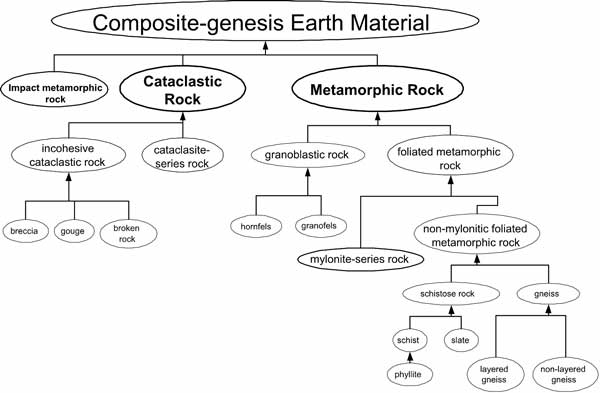 |
Figure 1. Simplified hierarchy of fabric-based composite-origin rock names.
|
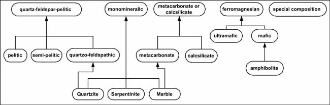 |
Figure 2. Simplified hierarchy of composition-based composite-origin rock name terms. |
Metamorphic rock (traditional sense)—A metamorphic rock has observable features that document change after the original formation of the rock, under physical or chemical conditions that differ from those normally occurring at the surface of the Earth and in zones of cementation and diagenesis below the surface (Smulikowski and others, 1997). The basic level of classification is the definition of fabric-based types described as hornfels, granofels, schist, layered gneiss, non-layered gneiss, slate, and mylonite-series rock (Table 3.3.1). In this classification, hydrothermally altered rocks are treated as metamorphic rocks; the full metamorphic classification is applied to these rocks without treating them as a distinct, separate category.
| Table 3.3.1 Fabric-based metamorphic-rock classes | |
|
Fabric-based
Metamorphic-rock Class |
Definition and scope notes
|
|---|---|
|
Hornfels
|
A non-foliated aphanitic metamorphic rock having granoblastic fabric. The term
does not necessarily denote a contact metamorphic origin, although that
is most commonly the case
|
|
Granofels
|
A phaneritic metamorphic rock that has little or no foliation or lineation, implying
that that less than 10% of the particles in the rock are fabric elements
that have an inequant shape and an aspect ratio ≥ 1.5:1
|
|
Schist
|
a phaneritic metamorphic rock that has well developed continuous schistosity. “Well developed” schistosity is defined here to mean that >50% of the rock consists of mineral grains having a tabular, lamellar, or prismatic
crystallographic habit that are oriented in a continuous planar or linear
fabric (Jackson, 1997). Continuous is defined to mean that domains lacking
the fabric are <1 cm thick if they are layers, and <5 cm in diameter if they are irregular patches, and constitute <25% of the rock. Phyllite is a fine-grained subclass of schist having an average
grain size between 0.25 mm and 0.1 mm and a silvery sheen.
|
|
Layered gneiss
|
a foliated, phaneritic rock that lacks well developed, continuous schistosity
and has laterally continuous compositional layering > 5 mm thick
|
|
Non-layered gneiss
|
a foliated, phaneritic rock that lacks both well developed, continuous schistosity
and laterally continuous compositional layering > 5 mm thick. “Laterally continuous” here means that layers defining the foliation can be traced > 10 cm (length of lateral continuity)
|
|
Slate
|
an aphanitic rock that has well developed schistosity (Brodie and others, 2002).
The definition of schistosity used in this classification requires that >50% of the rock consists of mineral grains having a tabular, lamellar, or prismatic
crystallographic habit that are oriented in a continuous planar or linear
fabric. In an aphanitic rock this determination is generally based on
indirect evidence, which is typically the presence of slaty cleavage,
and the sheen observed on parting surfaces due to alignment of tiny phyllosilicate
grains. An average grain size that is aphanitic (<0.1 mm), except for porphyroblasts, is specified for precision.
|
|
Mylonite-series rock
|
displays a foliation defined by the shapes of deformed mineral grains or grain
aggregates having aspect ratios > 1.5:1, >10% of the rock is composed of “matrix” showing evidence of tectonic reduction in grain size, and the foliation and
matrix have observable features that document continuous, crystal-plastic
deformation. Mylonite-series rock is subdivided according to matrix percentages
into protomylonite, mylonite, and ultramylonite (Sibson, 1977)
|
Composition-based rock classes include amphibolite, marble, and common monomineralic rocks such as quartzite and serpentinite, which are defined individually by modal mineral composition. Other monomineralic metamorphic rocks consisting predominantly (>75%) of a single mineral are classified as monomineralic-granofels, monomineralic-hornfels, monomineralic-schist, etc., depending on the fabric. Composition qualifiers defined on the basis of modal mineralogy (ferromagnesian, calcsilicate, carbonate, pelitic, semipelitic, quartzofeldspathic; see Table 3.3.2) are combined with a fabric term as in “pelitic schist.” Traditional non-systematic rock terms such as amphibolite that are based on modal mineralogy are also treated as composition qualifier terms. This classification leans towards a minimum of special rock names for unusual composition rocks, and such rocks would be assigned a “special composition’ qualifier. The uncontrolled rock-name field in the database is available to assign any special rock name the geologist may prefer.
| Table 3.3.2 Selected composition-based classes (qualifiers) | |
|
Composition qualifiers
|
Definition
|
|---|---|
|
amphibolite
|
Rock consists of >75% green, brown, or black amphibole plus plagioclase (including albite) and
amphibole >30% (modal) of whole rock, and amphibole >50% of total mafic constituents
|
|
argillic
|
Rock is apparently clay-rich. Use for aphanitic rocks
|
|
calcareous
|
Rock reacts to form bubbles when hydrochloric acid is applied. Use for aphanitic
rocks (e.g. hornfels)
|
|
calcsilicate
|
Rock consists of ≥ 50% calcsilicate or carbonate minerals and carbonate minerals
≤ calcsilicate minerals in mineral mode
|
|
ferromagnesian
|
Rock consists of >40% dark ferromagnesian minerals. Standard term defined by Bates and Jackson
(1987) to mean “containing iron and magnesium”
|
|
impure marble
|
Rock consists of >50% calcsilicate or carbonate minerals and relative proportion of calcsilicate
and carbonate minerals is unknown or not specified
|
|
mafic
|
Rock consists of ≥ 40% and <90% ferromagnesian minerals
|
|
marble
|
Rock consists of > 75% carbonate minerals
|
|
metacarbonate
|
Rock consists of >50% calcsilicate or carbonate minerals and carbonate minerals > calcsilicate minerals in mineral mode
|
|
monomineralic
|
Rock consists of >75% of a single mineral species and does not meet any of the other composition
terms (e.g. quartzite, calcite marble, dolomite marble, serpentinite…)
|
|
pelitic
|
Rock for which the sum of modal quartz+feldspar+ mica + aluminous mineral is
≥ 70%, and aluminous mineral + mica content is ≥ 40%
|
|
quartzite
|
Rock consists of ≥ 75% quartz
|
|
quartzofeldspathic
|
Rock for which the sum of modal quartz+feldspar+ mica + aluminous mineral is
≥70%, and quartz + feldspar (sensu Robertson, 1999) >60%
|
|
semipelitic
|
Rock for which the sum of modal quartz+feldspar+ mica + aluminous mineral is
≥70%, and quartz+ feldspar < 60%
|
|
silicic
|
Rock is apparently silica-rich. Use for aphanitic rocks. Bates & Jackson (1987) include denotation of igneous origin. For this classification,
should be considered to mean “appears to consist largely of quartz and feldspar”, generally is aphanitic with hardness >= 6.
|
|
special composition
|
Rock has a mineral composition that doesn’t fit in any defined composition class.
A modal mineral description is essential. The rock consists of <40% ferromagnesian minerals and <50% carbonate + calcsilicate minerals and <70% Q+Fs + mica + aluminous minerals
|
|
ultramafic
|
Rock consists of >90% ferromagnesian minerals
|
The SLTT classification of metamorphic rocks does not apply the ‘meta’ prefix to a protolith name (as in metasiltstone), because it cannot be simply integrated into a classification based on fabric and composition, and because interpretations of protolith can be highly subjective. Rock name terms in the form “meta-(some rock name)’ can be placed by the user in an uncontrolled rock name field and can also appear in a user interface by having underlying software that maps the name assignment to the implied dual classification. Where the protolith can be determined, the classification includes two distinct parts—a protolith classification using the criteria applicable to the protolith lithology, and a composite-genesis classification based on the fabric and composition criteria outlined here. The data model design should include a mechanism that allows the “dominant’ aspect of a rock that has multiple classifications to be specified.
Cataclastic rock—SLTT classifies a rock as cataclastic if >10% of the volume consists of fragments bounded by fractures. Cataclastic rocks are further classified based on the presence or absence of primary cohesion, the percentage of broken fragments large enough to be visible, and the amount of fragmental cataclastic matrix (Sibson, 1977; Snoke and Tullis, 1998) Cataclastic rock having evidence of primary cohesion is subdivided according to matrix percentages into protocataclasite, cataclasite, and ultracataclasite (Sibson, 1977). Cataclastic rock that lacks primary cohesion is subdivided into fault breccia (visible fragments>30% of rock) and gouge (visible fragments <30%).
Impact-metamorphic rock—Impact-metamorphic rocks have observable features, such as microscopic planar deformation features, that are unequivocally the result of shock metamorphism (Stöffler and Grieve, 2001), high-pressure minerals, or field evidence such as shatter cones and crater structure. Adapting Stöffler and Grieve’s (2001) IUGS recommendations with slight modifications, impact-metamorphic rock is classified as shocked rock, impact melt rock, or impact breccia.
3.4 Sedimentary materials
The SLTT Sedimentary Subgroup developed science language for the lithologic classification (material name), physical characteristics, and origin and depositional history of sedimentary materials.
3.4.1 Classification
At the top hierarchical level, sedimentary earth materials are classified into eight categories based on sediment composition (Table 3.4.1.1). At a high level, unconsolidated sediment is distinguished from consolidated rock, and separate (but parallel) naming schemes are developed for each consolidation state.
| Table 3.4.1.1 Higher taxonomic levels of sedimentary-material classification | |
|
Sedimentary Material
(unconsolidated, consolidated) |
Definition
|
|---|---|
|
Sedimentary material, unclassified
|
Not enough information is known about a sedimentary material to classify it as
anything other than sedimentary rock or sediment
|
|
Terrigenous-clastic sedimentary material
|
A rock or sediment composed principally of broken fragments that are derived
from the land or continent. To be considered as terrigenous-clastic,
a rock (sediment) must have ≥ 50% of its constituents derived from the
land or continent
|
|
Carbonate sedimentary material
|
Sediment or sedimentary rock ≥50% of whose primary and (or) re-crystallized constituents
are composed of carbonate minerals (calcite, aragonite, dolomite). By
definition, such materials are intra-basinal in origin—that is, they formed by processes operating within the depositional regime, and
were not transported into that regime from other sediment sources
|
|
Organic-rich sedimentary
material
|
Sedimentary materials having sufficiently high organic content that they can
not be identified as another kind of sedimentary rock (e.g., terrigenous-clastic
or carbonate). Pragmatically, SLTTS_1.0 places this threshold at ≥50%
organic content by weight to be consistent with the established definition
for coal without conflicting with definitions of other compositionally-based
categories
|
|
Non-clastic siliceous sedimentary material
|
Sedimentary materials dominated by non-clastic silica are those composed of ≥50%
silica of biogenic or chemical origin (Hallsworth and Knox, 1999, p.
21)
|
|
Noncarbonate-salt sedimentary material
|
Sedimentary materials dominated by non-carbonate salts are those whose primary
constituents consist of chloride, sulphate, or borate minerals. Such
materials also are known as evaporite materials because they form through
evaporative precipitation of mineral salts from brines—either directly from the water column or from pore fluids during diagenesis
|
|
Phosphate-rich sedimentary material
|
Phosphatic sedimentary materials are those in which phosphate minerals or phosphatic
component comprise >50% of the sedimentary framework as determined by hand-lens or petrographic analysis
(Hallsworth and Knox, 1999). This corresponds with a rock (sediment)
typically containing ≥15% P2O5 (by weight)
|
|
Iron-rich sedimentary material
|
Iron-rich sedimentary materials are those in which iron-bearing minerals comprise
≥50% of the sedimetary framework as determined by hand-lens or petrographic
analysis (Hallsworth and Knox, 1999). This corresponds with a rock (sediment)
typically containing ≥15% iron (by weight)
|
Within each compositional category, lower-level (more detailed) material names are based on textural or compositional criteria (or both), depending on the parent category.
3.4.2 Unconsolidated versus consolidated sedimentary materials
The distinction between “unconsolidated” and “consolidated” (sediment versus rock) occupied considerable SLTT discussion and attention. We concluded that SLTT can suggest guidelines for distinguishing unconsolidated from consolidated materials. However, ultimately it will be the subjective decision of the data producer as to whether a specific sedimentary material is “consolidated” or “unconsolidated” according to his or her judgment. Table 3.4.2.1 provides guidelines that can facilitate this determination.
| Table 3.4.2.1 Degrees of consolidation (modified from Bowles, 1984, Table 5-2) | |||
|
Lithification State
|
Field Criterion
|
Relative
Density (Dr)4 |
|
|---|---|---|---|
| Unconsolidated | Very slightly consolidated | Easily indented with fingers | 0.00–0.20 |
| Slightly consolidated | Somewhat less easily indented with fingers. Easily shoveled |
0.20–0.40 | |
| Moderately consolidated | Shoveled with difficulty | 0.40–0.70 | |
| Consolidated | Well consolidated | Requires pick to loosen for shoveling | 0.70–0.90 |
| Lithified | Requires blasting or heavy equipment to loosen | 0.90–1.00 | |
| Indurated | Rings to the blow of a hammer | 1.00 | |
| 4As translated by Bowles (1984, p. 151–152), relative density is an engineering parameter that relates void space determined in the laboratory to a ratio involving index values of minimum and maximum void space for specified materials under specified conditions. Void space in turn is related to in situ dry unit weight. Also see the Glossary of Geology definition of relative density (Jackson, 1997, p. 540). | |||
3.4.3 Outcrop characteristics of sedimentary materials
SLTT developed science language for a variety of attributes that characterize the outcrop appearance of sedimentary materials (Table 3.4.3.1):
| Table 3.4.3.1 Outcrop characteristics of sedimentary materials | |
|
Science Concept
|
Data-Field Content
|
|---|---|
|
Lithotope abundance
|
Indicates the relative abundance of each lithotope in an outcrop
|
|
Map-unit geomorphology
|
Describes how a map unit crops out (prominent, subdued)
|
|
Outcrop profile
|
Describes how individual lithotopes crop out (ledge-forming, slope-forming, etc.)
|
|
Outcrop weathering
|
Describes how sedimentary materials weather (cavernous, friable, etc.)
|
|
Upper-surface geomorphology
|
Describes various features associated with the upper surface of unconsolidated
materials (dissection, pavement, pedogenic soils, clast weathering, etc.)
|
|
Material color (fresh)
|
Describes the color of fresh geologic materials
|
|
Material color (weathered)
|
Describes the color of weathered geologic materials
|
|
Material color (dry)
|
Describes the color of dry geologic materials
|
|
Material color (wet)
|
Describes the color of wet geologic materials
|
|
Consolidation state
|
Describes how firm and knitted together a sedimentary material is, and how hard
it is once it has been lithified
|
3.4.4 Sedimentary structures
The SLTT classifies sedimentary structures into primary and secondary structures:
Primary sedimentary structure—A sedimentary structure, either inorganic or organic, formed during the accumulation and (or) penecontemporaneous modification of sediment, intrinsically reflecting conditions of the sedimentary environment.
A primary structure reflects one of the following processes:
Secondary sedimentary structure—A sedimentary structure “...that originated subsequently to the deposition...of the rock in which it is found...; esp. an epigenetic sedimentary structure, such as a concretion or nodule produced by chemical action, or a sedimentary dike formed by infilling” Glossary of Geology (Jackson, 1997, p. 576).
Not included as secondary sedimentary structures are:
The essential ingredient of secondary sedimentary structures is that they have no intrinsic relation with conditions of the sedimentary environment. This distinguishes secondary structures from primary structures.
Table 3.4.4.1 summarizes major categories of sedimentary structures.
| Table 3.4.4.1 Classification of sedimentary structures |
|
Primary Structures Inorganic structures Syngenetic structures Depositional structures Erosional structures Penecontemporaneous structures Bed-surface structures Within-bed structures Multi-bed structures Biogenic Structures Secondary Structures Secondary deformation structures Sedimentary hardground Dissolution structures Epigenetic growth structures Unclassified Structures Bed-surface structures Within-bed structures Multi-bed structures |
3.4.5 Fabric and texture of sedimentary materials
SLTT developed science language for a variety of attributes that characterize the fabric and texture of sedimentary materials (Table 3.4.5.1).
| Table 3.4.5.1 Fabric and texture elements for sedimentary materials | |
|
Science Concept
|
Data-Field Content
|
|---|---|
|
Preservation of depositional fabric
|
Yes or no
|
|
Grain-support versus matrix support
|
Indicates whether fabric is clast-supported or matrix-supported
|
|
Particle size, matrix grain size (range)
|
Indicates range of matrix grain size
|
|
Particle size, matrix grain size (average)
|
Indicates mean of matrix grain size
|
|
Particle size, particle grain size (range)
|
Indicates range of particle grain size
|
|
Particle size, particle grain size (average)
|
Indicates mean of particle grain size
|
|
Particle sorting
|
Indicates sorting in terms of Inclusive Graphic Standard Deviation (Folk, 1968)
|
|
Particle shape and rounding
|
Indicates the shape of grains and clasts (rounded, subangular, tabular, spherical,
etc.)
|
|
Coated particles
|
Indicates the fabric type created by particle coating (ooidal, pisoidal, oncoidal)
|
|
Particle orientation
|
Indicates the geometric orientation of elongate or disk-shaped particles
|
|
Particle packing
|
Indicates the spacing or density patterns of particles as expressed by nature
of grain contacts
|
3.4.6 Sedimentary genesis
SLTT classifies sedimentary genesis according to a scheme that integrates three attributes:
Ultimately, it is the interaction between depositional process and depositional environment that yields a depositional product. This interaction can be viewed as a two-dimensional matrix in which process is arrayed against place (Table 3.4.6.1).
| Table 3.4.6.1 Two-dimensional matrix that arrays depositional process (left) against depositional environment (right) to yield cells in which a depositional product may or may not occur (for examples, see Table 3.1.4). NOTE: Table 3.4.6.1 depicts only the highest-level categories for process and environment; the matrix can be expanded to expose deeper and deeper categories. Also Note: Not all combinations of process and environment are possible (hence, no depositional product exists). | |||||||
|
ENVIRONMENTS
(major environments only) |
|||||||
|
Terrestrial
|
Marginal
marine |
Marine
|
|||||
|---|---|---|---|---|---|---|---|
|
PROCESSES
(major processes only) |
Inorganic Processes
|
Chemogenic Processes
|
Evaporative precipitation |
||||
| Seafloor precipitation | |||||||
| Fluid-Flow | Aqueous-flow | current flow | |||||
| fluvial flow | |||||||
| overland-flow | |||||||
| wave action | |||||||
| Eolian-flow | dune- and sand-sheet processes | ||||||
|
Gravitational
Potential Energy |
Mass-wasting | subaerial | |||||
| subaqueous | |||||||
| Particle Settling | object plummeting | ||||||
| suspension deposition | |||||||
| Impact-ejecta accumulation | |||||||
| Solid-flow | Ice-flow | ||||||
|
Biogenic Processes
|
Sediment-production | biogenic oozes | |||||
| Framework-building | framework-built reefs | ||||||
| Sediment-binding | organic mats | ||||||
| Sediment-trapping | organic-baffles and reef mounds | ||||||
In Table 3.4.6.1, the intersection of a genetic process with a sedimentary environment yields a grid cell that represents a potential depositional product. Table 3.4.6.2 lists representative examples (but not all examples) of such products.
| Table 3.4.6.2 Representative examples of deposit types that represent the intersection of depositional process and depositional environment (see Table 3.4.6.1) | |||||||
|
algal-mat deposit
|
bog deposit
|
bar deposit
|
beach deposit
|
braided-channel deposit
|
channel deposit
|
chute-channel deposit
|
crevasse-channel deposit
|
|
crevasse-splay deposit
|
debris-flow deposit
|
distributary-mouth bar deposit
|
dune deposit
|
fan deposit (subaerial)
|
fan deposit (subaqueous)
|
fan-delta deposit
|
flood-plain deposit
|
|
glacial-till deposit
|
inlet channel fan deposit
|
lagoon deposit
|
levee deposit (subaerial)
|
levee deposit (subaqueous)
|
marsh deposit
|
meandering-channel deposit
|
mud-flat deposit
|
|
overbank-fines deposit
|
pelagic-ooze deposit
|
pond deposit
|
reef, framework-built
|
reef, sediment-trapping
|
sabkha deposit
|
sand-flat deposit
|
sand-flat deposit
|
|
sheet-flow deposit
|
sheet-sand deposit
|
shelf deposit
|
slide deposit
|
slope deposit
|
slump deposit
|
supratidal-flat deposit
|
swamp deposit
|
|
tidal-channel deposit
|
tidal-flat deposit
|
tidal-inlet deposit
|
tidal-ridge deposit
|
turbidite deposit
|
washover-fan deposit
|
||
All three genetic attributes (depositional process, depositional environment, depositional product) can be classified hierarchically to yield a complete description of how a sedimentary material was formed.
4 PEDOGENIC MATERIAL
SLTT has not yet found a satisfactory basis for classifying pedogenic-soil materials. A pedogenic soil is a parent material that has developed soil structure, texture, and mineralogy (horizonation) through a variety of physical, chemical, and biologic agents. Horizon development in the parent materials thus is a secondary process, not a primary process that leads to a first-generation earth material. Even though pedogenic processes take place at temperatures, pressures, and physical-chemical environments at the Earth’s surface, soil-forming processes are akin to “metamorphism” in the sense that an original earth material (parent material) is transformed into another earth material (pedogenic soil). Thus, pedogenic material could be included within the composite-genesis category. However, some SLTT members argue that pedogenic soil properly belongs within the sedimentary category, while others maintain that pedogenic soil is a high-level taxonomic category comparable to igneous, sedimentary, and composite-genesis materials. SLTT hopes to resolve these conflicting interpretations by the time the science-language documents are released for widespread North American peer review.
5 CONCLUSIONS
The use of standardized science language in digital geologic-map databases is a new frontier that is likely to evolve with time and experience. With this in mind, we are developing a classification of earth materials that we believe reflects not only how mapping geologists view them but also how such materials might be queried and analyzed in digital geologic-map databases. No single classification of earth materials is going to please all workers. However, the schemes we propose hopefully will be clearly understandable, internally consistent, and usable by both data-producer and data-user.
6 REFERENCES CITED
Bowles, J.E., 1984, Physical and geotechnical properties of soils: New York, McGraw-Hill Book Company, 2nd Edition, 578 p.
Brodie, K., Fettes, D., Harte, B., and Schmid, R., 2002, Towards a unified nomenclature of metamorphic petrology: 5. Structural terms including fault rock terms, A proposal on behalf of the IUGS Subcommission on the Systematics of Metamorphic Rocks, Web version of 31.10.2002: 8 p., available online at http://www.bgs.ac.uk/SCMR
Dreimanis, A., 1988, Tills: their genetic terminology and classification, in Goldthwait, R.P., and Matsch, C.L., eds., Genetic classification of glacigenic deposits (Final report of the Commission on Genesis and Lithology of Glacial Quaternary Deposits of the International Union for Quaternary Research [INQUA]): Rotterdam, A.A. Balkema, p. 17-83.
Foley, S.F., Venturelli, G., Green, D.H., and Toscanni, L., 1987, The ultra potassic rocks: characteristics, classification and constraints for petrographic models: Earth Science Reviews, v. 24, p. 81–134.
Folk, R.L., 1968, Petrology of sedimentary rocks: Austin, Texas, Hemphill’s Bookstore, 170 p.
Gillespie, M.R., and Styles, M.T., 1999, Classification of igneous rocks: Volume 1 of the BGS rock classification scheme: British Geological Survey Research Report Number RR 99-06, 52 p.
Goldthwait, R.P., and Matsch, C.L., eds., 1988, Genetic classification of glacigenic deposits (Final report of the Commission on Genesis and Lithology of Glacial Quaternary Deposits of the International Union for Quaternary Research [INQUA]): Rotterdam, A.A. Balkema, 294 p.
Goldthwait, R.P., Matsch, and Dreimanis, A., 1988, Preface, in Goldthwait, R.P., and Matsch, C.L., eds., Genetic classification of glacigenic deposits (Final report of the Commission on Genesis and Lithology of Glacial Quaternary Deposits of the International Union for Quaternary Research [INQUA]): Rotterdam, A.A. Balkema, p. vii-ix.
Hallsworth, C.R., and Knox, R.W.O’B., 1999, Classification of sediments and sedimentary rocks: Volume 3 of the BGS rock classification scheme: British Geological Survey Research Report Number RR 99-03, 44 p.
Heiken, G., and Wohletz, K.H., 1985, Volcanic ash: Berkeley, University of California Press. International Union of Geological Sciences Subcommission on the Systematics of Igneous Rocks, 1973, Plutonic rocks: Geotimes, v. 18, no. 10, p. 26-30.
Jackson, J.A., 1997, Glossary of geology, 4th ed.: Alexandria, Virginia, American Geological Institute, 769 p. Le Bas, M.J., and Streckeisen, A., 1991, The IUGS systematics of igneous rocks: Journal of the Geological Society of London, v. 148, p. 825–833.
Le Bas, M.J., Le Maitre, R.W., Streckeisen, A., and Zanettin, B., 1986, A chemical classification of volcanic rocks based on the total alkali-silica diagram: Journal of Petrology, v. 27, p. 745–750.
Le Maitre, R.W., and 11 others (editors), 1989, A classification of igneous rocks and glossary of terms: Recommendations of the International Union of Geological Sciences Subcommission on the Systematics of Igneous Rocks: Oxford, Blackwell Scientific Publications.
Le Maitre, R.W. (editor), 2002, Igneous rocks, A classification and glossary of terms, second edition: Cambridge, Cambridge University Press, 2nd edition 236 p.
MacDonald, R., 1974, Nomenclature and petrochemistry of the peralkaline oversaturated extrusive rocks: Bulletin Volcanologique, v. 38, p. 498–516.
McMillan, A.A., and Powell, J.H., 1999, Classification of artificial (man-made) ground and natural superficial deposits: applications to geological maps and datasets in the UK: v. 4 of the BGS rock classification scheme: British Geological Survey Research Report Number RR 99-04, 65 p.
North American Commission on Stratigraphic Nomenclature, 1983, North American stratigraphic code: American Association of Petroleum Geologists Bulletin, v. 67, no. 5, p. 841-875.
North American Data Model Steering Committee, 2003, Proposed North American standard conceptual model for geologic map information, version 1.0: U.S. Geological Survey Open-File Report 04-XXX (http://)
Robertson, S., 1999, Classification of metamorphic rocks: Volume 2 of the BGS rock classification scheme: British Geological Survey Research Report Number RR 99-02, 24 p.
Schmid, R., 1981, Descriptive nomenclature and classification of pyroclastic deposits and fragments: Recommendations of the IUGS Subcommission on the Systematics of Igneous Rocks: Geology, v. 9, p. 41–43.
Schmid, R., Fettes, D., Harte, B., Davis, E., Desmons, J., and Siivola, J., 2002, Towards a unified nomenclature in metamorphic petrology: 1. How to name a metamorphic rock, A proposal on behalf of the IUGS Subcommission on the Systematics of Metamorphic Rocks, Web version of 31.07.2002: 13 p., available online at http://www.bgs.ac.uk/SCMR
Sibson, R.H., 1977, Fault rocks and fault mechanisms: Journal of the Geological Society of London, v. 133, p. 191-213.
Smulikowski, W., Desmons, J., Harte, B., Sassi, F.P., and Schmid, R., 1997, Towards a unified nomenclature of metamorphism: 3. Types, grade and facies [A proposal on behalf of the IUGS Subcommission on the Systematics of Metamorphic Rocks], compiled 1 September 1997 and corrected 19 November 1997: 13 p., available online at http://www.bgs.ac.uk/SCMR.
Snoke, A.W., and Tullis, J., 1998, An overview of fault rocks, in Snoke, A.W., Tullis, J., and Todd, V.R., Fault-related Rocks, A Photographic Atlas: Princeton, N.J., Princeton University Press, p. 3-18.
Stöffler, D., and Grieve, R.A.F., 2001, IUGS classification and nomenclature of impact metamorphic rocks: Towards a final proposal [indexed as: Towards a unified nomenclature of metamorphism: IUGS classification and nomenclature of impact metamorphic rocks. A proposal on behalf of the IUGS Subcommission on the Systematics of Metamorphic Rocks, Web version of 14.01.2001]: 3 p., available online at http://www.bgs.ac.uk/SCMR.
Streckeisen, A. 1974, Classification and nomenclature of plutonic rocks: Recommendations of the IUGS Subcommission on the Systematics of Igneous Rocks: Geologische Rundschau Internationale Zeitschrift für Geologie: Stuttgart, v. 63, p. 773–785.
Streckeisen, A. 1976, To each plutonic rock its proper name: Earth Science Reviews, v. 12, p. 1–33.
Streckeisen, A. 1978, IUGS Subcommission on the Systematics of Igneous Rocks: Classification and nomenclature of volcanic rocks, lamprophyres, carbonatites and melilitic rocks. Recommendations and suggestions: Neues Jahrbuch für Mineralogie, v. 134, p. 1–14.
Streckeisen, A. 1979, Classification and nomenclature of volcanic rocks, lamprophyres, carbonatites and melilitic rocks: recommendations and suggestions of the IUGS Subcommission on the Systematics of Igneous Rocks: Geology, v. 7, p. 331–335.
Webster’s Encyclopedic Unabridged Dictionary of the English Language, 2001: San Diego, Thunder Bay Press, 2230 p.
APPENDIX 1
PROPOSED NORTH AMERICAN GEOLOGIC-MAP
DATA MODEL
SCIENCE-LANGUAGE TECHNICAL TEAM CHARTER
11/1/99
Executive Statement.—See the Data Model Steering Committee (DMSC) charter for an executive statement on technical teams.
MANDATE AND CHARGE
Mandate.—The Science Language Technical Team (SLTT) is mandated to develop standardized nomenclature for digital geologic-map databases—including (but not limited to) the following areas:
The standardized terminology will support a proposed standard geologic-map data model for North America.
Charge.—To achieve its mandate, the Science Language Technical Team is charged with the following tasks:
Authority.—The SLTT derives its authority and legitimacy from the DMSC, which provides guidance and requirements on behalf of the constituencies it represents.
Accountability.—The SLTT is accountable to the DMSC. Through a representative mutually acceptable to the SLTT and DMSC, the SLTT periodically apprises the Steering Committee of progress toward science language terminology and about issues and problems that need consideration by the DMSC.
TECHNICAL-TEAM OPERATIONS
Execution of work.—The SLTT will convene an initial meeting to evaluate goals and to discuss issues, problems, and terminology strategies. The Technical Team should have as many face-to-face meetings as required to allocate responsibilities and to resolve issues and problems not easily resolvable via e-mail.
Lateral Coordination.—The SLTT will regularly communicate strategies and proposed terminologies laterally to other Technical Teams—especially the Data-Model Design Technical Team—in order to ensure that data-model architecture and software tools consistently reflect the evolving science language and concepts.
Technical Review.—Science-language documents prepared by the SLTT will be presented to the DMSC for initial review and evaluation for compliance with the overall goals of the North American geologic-map data model. Following DMSC review and SLTT response, the science-language documents will be widely distributed for technical peer review by the geosciences community (probably through a web-based venue).
TECHNICAL-TEAM MEMBERSHIP
Work Group Size.—The size of the SLT should be commensurate with its mandate: If geologic and political realities require that the scope and content of data-model science language be generalized and narrow, then the size of the Technical Team should be small; however, if the scope and content of data model science language is to be comprehensive and detailed, then the size of the Technical Team should be large enough to ensure scientific comprehensiveness and consensus of the larger geologic community.
Scientific Breadth.—SLTT membership should span the range of surficial and bedrock geologic disciplines, including expertise in sedimentary, igneous, metamorphic, structural, stratigraphic, and geomorphic/pedogenic arenas. Experts on specific scientific disciplines can be added for short durations to address specific geologic issues that arise during SLTT deliberations.
Geographic Breadth.—SLTT membership should include a broad range of geographic representation so as to reflect provincial geologic usages.
Constituency Breadth.—SLTT membership should represent the constituencies that will contribute to geologic map databases—initially including the U.S. Geological Survey (USGS), the Association of American State Geologists (AASG), the Geological Survey of Canada (GSC), and the Canadian Provincial Surveys. Inclusion of industry and academic participants will depend on the narrowness or breadth of the science-language standards.
Appointment procedure.—SLTT members shall be appointed by the DMSC based on the recommendations of each constituency and considering the criteria defined in Scientific, Geographic, and Constituency Breadth:
Lifespan of Technical Team.—Continued existence of the SLTT as a standing committee responding to data-model science–language needs shall be at the discretion of the DMSC. The SLTT will remain intact during the review period, and shall respond to Steering Committee review and to peer review until such time as version 1.0 of the science-language classification is adopted for use in the draft standard data model.
MILESTONES
Within a year of convening its first session, the SLTT shall carry out its charge to produce one or more science-language strawman classifications. The SLTT receives guidance on milestones from the DMSC, evaluates their feasibility, and reaches targets in conjunction with DMSC.
APPENDIX 2
Memoranda from SLTT Chair (J.C. Matti) to SLTT committee members
Memorandum from SLTT Chair to SLTT committee members (4/03/2000)
| Participants on the Science Language Technical Team For a Proposed North American Geologic-Map Data Model |
04/03/2000
|
Science Language Technical Team colleagues:
By now, each of you hopefully is aware that you have been selected as a participant on a technical team (Science Language Technical Team, SLTT) tasked with coming to groups with how (or whether) a common set of geoscience terms can be developed for digital geologic-map data bases produced in North America. The SLTT is one of several parallel teams commissioned on behalf of a proposed North American Geologic-Map Data Model.
Background
A standardized data-base model for the input, storage, manipulation, retrieval, and analysis of digital geologic-map information is being developed by a consortium of interests, including the Association of American State Geologists (AASG), the U.S. Geological Survey (USGS), the Geological Survey of Canada (GSC), and the Canadian Provincial Surveys. The data model currently being evaluated was developed as a cooperative venture by the USGS, the GSC, and the AASG.
This model attained visibility through a series of workshops and through presentations at national GSA meetings. It developed as a likely candidate for a North American data-model standard, and over a period of time was revised and refined under the aegis of the AASG, the USGS, and the GSC. The data model can be found on the World Wide Web at http://geology.usgs.gov/dm/model/Model43a.pdf (version 4.3, Johnson and others, 1999). Continued development of a data-model standard is proceeding under the auspices of a multi-constituency North American Data Model Steering Committee (NADMSC, http://geology.usgs.gov/dm/steering/), which has commissioned the technical teams that are developing various aspects of the data model.
How did you come to be a participant in this process?
Scientists from the American state geological surveys were identified by the Association of American State Geologists. Participants from the USGS were nominated through a process that was coordinated through the three Regional Geologists and through the Geologic Division Program Coordinators. The two Canadian participants represent the Provincial surveys and the Geological Survey of Canada; hopefully, additional Canadian participants will be identified in the near future. I am in the process of recruiting a few representatives from the geologic-map using community within the U.S. Departments of Interior and Agriculture, one of whom has been identified. All of you are viewed as ideal for responding to the task before us.
Where is the SLTT process now, and what is next?
It has taken a while to establish the SLTT membership because it has not been easy to coordinate among multiple constituencies. But, we are about there, so I thought I would bring you up to speed, and address some mechanical issues.
I will be on the road for most of this week, and not able to check my email for much of that time. Please use this period before 17 April to get yourself into the swing of things regarding geologic-map standards. I will be back in contact next week with more mechanical issues.
In the meantime, here is our first task:
In order to set the tone for our task and see how each of us views the information content of a geologic map, please come up with 20 data-base queries that you personally would want to launch at a digital geologic-map data base. We can exchange these query-lists by email, and post them at the web-conference site. Use the following syntax:
I will come through with my 20, but this quick sample represents just a smattering of topics and issues that I would need to retrieve from a typical geologic-map data base in southern California. Good luck, and have fun.
Personally, I am looking forward to working with all of you. Collectively, we represent a considerable body of common sense, scientific breadth, and geologic-map experience (either on the data-production side or the data-use side). With such a mix, I am confident that we will do justice to the notion of common standards for geologic-map terminology—or, if such standards can not be developed and adopted, then at least a good set of minds will have reached that conclusion.
Adios from Tucson, Jonathan
MEMORANDUM FROM SLTT CHAIR TO SLTT COMMITTEE MEMBERS (4/03/2000)
SCIENCE-LANGUAGE TECHNICAL TEAM
Guidance from the North American data-model
Steering Committee
04/03/2000
MANDATE
The Science Language Technical Team (SLTT) is mandated to develop standardized nomenclature for digital geologic-map data bases, including (but not limited to) the following areas:
GUIDING PRINCIPLES
MEMORANDUM FROM SLTT CHAIR (MATTI) TO
SLTT COMMITTEE MEMBERS
(12/01/2000)
SCIENCE-LANGUAGE TECHNICAL TEAM
Action Plan
1 December, 2000
SLTT colleagues:
About 15 of us got together the morning of 13 November [at Geological Society of America Annul Meeting, Reno, Nevada, 2000] to discuss general issues and to develop an action plan for our science-language activities. This document summarizes the discussions, and provides the guidance for our activities over the next few months.
Participants
Lucy Edwards (USGS)
Bruce Johnson
(USGS)
Ron Kistler (USGS)
Alison Klingbyle (GSC)
Diane
Lane (USGS)
Steve Ludington (USGS)
Jim MacDonald (Ohio
Geological Survey)
Jon Matti (USGS)
David Miller (USGS)
Steve Richard (Arizona Geological Survey)
Peter Schweitzer
(USGS)
Loudon Stanford (Idaho Geological Survey)
Andy
Rorick (U.S. Forest Service)
Richard Watson (U.S.
Bureau of Land Management)
Jerry Weisenfluh (Kentucky
Geological Survey)
(1) What we need to do
- definitions of control-terms
- diagrams of parent-child relations
- Minimal boiler-plate that describes our results and places them in the context of the proposed North American geologic-map data model
(2) Specific components of 1.0 strawman
- rock name (e.g., limestone, monzogranite, blueschist, colluvium)
- lithologic attribute (e.g., coarse-grained, fissil-weathering, thin-bedded, unconsolidated, texturally massive, porphyritic, porphyroclastic, mullion)
- rock genesis (e.g., marine, nonmarine, alluvial, plutonic, volcanic, fluvial, colluvial, dynamothermal, high-strain)
- genetic structures (e.g., flow foliation, eutaxitic fabric, cumulate layering, graded bedding, sole structures, slaty cleavage, earth flow,)
- Harland and others (1989)
- IUGS timescale (Remane, 2000)
- time scales compiled in Berggren and others (1995)
(3) Target Audience
Science language should be technical—that is, it should be developed by and speak to the trained geologist. Although we all are concerned about how the professional and non-professional non-geoscience audience will access and understand our database content, this concern should be addressed by a technical team tasked with designing the data-model user interface.
(4) Basis and scale of terminology
Map-unit categories (i.e., formation, member, tongue, lentil, bed) are conceived and extended through a process that integrates hierarchical observations beginning at the hand-sample and outcrop level but extending to the hillside and regional level and augmented by the thin-section and chemical-analysis level. Thus, hierarchical terminology schemes leading to map-unit description should reflect:
(5) Existing strawman-classifications for consideration include (but are not limited to):
(6) In addition to nomenclature for sedimentary, igneous, metamorphic, and surficial materials, we need to develop language for the following materials:
(7) The following rules MUST be adhered to:
(8) To assist data-model design team, we need to distinguish between the following terms:
(9) To assist data-model design team in developing a map-unit characterization field
References Cited
Berggren, W.A., Kent, D.V., Aubry, M-P., and Hardenbol, J., eds., 1995, Geochronology, time scales and global stratigraphic correlation: Tulsa, Oklahoma, Society of Economic Paleontologists and Mineralogists, Special Publication 54, 386 p.
Harland, B.W., Armstrong, R.L., Cox, A.V., Craig, L.E., Smith. A.G., and Smith, D.G., 1989, A geologic time scale, 1989: New York, Cambridge University Press, 246 p.
Remane, Jurgen, compiler, 2000, International Stratigraphic Chart: Division of Earth Sciences, UNESCO, 16 p., 1 plate. Published in cooperation with the International Union of Geological Sciences and the International Commission on Stratigraphy.
MEMORANDUM
FROM SLTT CHAIR (MATTI) TO SLTT SEDIMENTARY
AND SURFICIAL
SUBGROUP MEMBERS (2/15/2001)
| Sedimentary and Surficial Subgroup Colleagues: |
02/15/2001
|
Now that the surficial and sedimentary SLTT teams both have launched their deliberations, we need to address an issue of concern to both teams.
Several members of the sedimentary group have indicated concern about possible overlap between “unconsolidated” sediment and unconsolidated surficial materials. This concern originates from the British Geological Survey’s (BGS) classification of sedimentary materials into “lithified” and “unlithified” materials:
“The primary classification of sediments and sedimentary rocks is based on their compositional attributes present at the time of deposition. This allows sediments to be classified by the same compositional boundaries as sedimentary rocks.”
The following points address this issue, and seek to clarify the unique assignments of the surficial-materials team and the sedimentary team. As you see fit, please comment on any of the points:
- the surficial team is classifying deposit types that can be used as map units, and that also may occur within map units, but are not specific lithologies or petrographic sediment names
- the sedimentary team is classifying rock types that occur as specific lithologies in outcrops and in map units
- the sedimentary team will develop much of the classification and description nomenclature for specific rock types, but they must do so in partnership with the surficial team so that cross-pollination occurs
Please ruminate over the ideas in this note. If we are not on the same page on this one, we could get into trouble. I am just thinking out loud, so give it your own treatment.
Adios, Jonathan
MEMORANDUM FROM SLTT CHAIR (MATTI)
TO SLTT COMMITTEE MEMBERS
(3/14/2001)
| Sedimentary and Surficial Subgroup Colleagues: |
03/14/2001
|
Recent discussion within some of the subgroups indicates the need to restate and clarify the purpose of our SLTT goals and the nature of our classification activities. Please read this memo carefully and at your earliest convenience. If any of you has major reservations, concerns, or disagreements about these objectives, please raise them to all of us now. By separate mailing, I am sending a copy of this memo to the North American Data Model Steering Committee, whose members also are asked to comment and evaluate the statements.
(1) Databases versus geologic-maps: Our purpose is to develop classification structures for digital geologic-map databases, not for digital versions of geologic maps. The production of a geologic-map plot is incidental to the database, and is not the primary focus of the language that the SLTT is developing.
The difference in tone here is important: the hierarchical structure, number of rock classes, and other aspects of our language schema should be tailored to storing and searching science concepts in a digital database, not tailored to the requirements of database fields in a particular data model or tailored to the text in a geologic-map legend.
(2) Language for new data versus language for compilation: While the compilation of pre-existing geologic mapping obviously is part of a geologist’s activities, the SLTT’s primary driver is to develop schema that facilitate the classification and communication of new field information. We must look into the future toward novel ways of organizing new data, not into the past to find ways of facilitating the compilation of old data. The former will benefit the latter in obvious ways.
Map compilation (the collation, evaluation, interpretation, and translation of geologic-map information contained in products produced by other workers) is a necessary and legitimate goal. However, the creation of science language that supports geologic-map compilation is not the SLTT purpose.
(3) Do we need to accommodate pre-existing science language?: Compilation of pre-existing geologic-map information requires the geologist to deal with a wide array of lithologic names and descriptors that have come down through the generations. Should the SLTT classification schema create a place for these terms, or define equivalencies for them?
No. Our task is to create a single uniform, coherent classification that logically, objectively, and thoughtfully establishes rock names and descriptors that classify geologic materials accurately and comprehensively according to modern usage. We are not obliged to create a list of synonyms or equivalencies. We are not necessarily required to make a place for previous usage, no matter how entrenched that usage might be.
For the compilation of pre-existing map information, it is (and always should be) the responsibility of the map compiler to interpret what a published geologic map contains, and to place this information in the context of modern rock classifications. This is why geologists (who have the training and expertise to make geologic judgments) should be map compilers. The SLTT classification schema will be the modern standard for geologic-map database attributes. It will be the responsibility of future map compilers to interpret the nomenclature of pre-existing geologic-map information for its position in the SLTT schema, not the responsibility of the SLTT to accommodate all previous language. Pre-existing language should be treated either in feature-level metadata or dataset metadata: this will create a paper trail for original usage, but will not burden the SLTT schema with the diverse nomenclature of the past.
(4) Language for data producer versus end user: The lithologic classification schema we are developing are NOT for the end user, but for the geologist who is collecting attribute data and populating a database with the attributes. The production of derivative databases and map plots that serve end users is not the SLTT concern.
Does this mean that the SLTT is not mindful of end-users? Nope. Each of the four subgroups is working hard to develop science language that will form a foundation for users of all kinds—from technical to non-technical. But the SLTT focus needs to be geologist-directed in order for the multiple-user base to be served.
We all are interested in and concerned about how end users access and use geologic-map information. However, I strongly believe that the proper focus of end-user facilitation should be the design of an appropriate user-interface. It will be the job of (a) the SLTT, (b) the data-model design team, and (c) a user-interface team (currently not designated) to design an appropriate tool-set to take the concepts and language designed by the SLTT and make them user-friendly.
(5) Hand-sample language versus map-unit language: The SLTT mandate is to provide classification schema for individual rock types that occur in geologic-map units, together with language that describes the physical appearance, composition, and genesis of these rock types. The science language must focus on hand-sample and outcrop-scale attributes, but should include rock names and fabric relations that derive from thin-section observations as well as language for sequencing and stratigraphic relations at the map-unit scale.
(6) How comprehensive or finite should our classification schema be? Our science language should reflect the realities of geology, not the requirements of end users. However, the geologic universe is complex, so should the classification schema be complex and opaque? Nope. And that is the challenge: to represent rock names and rock structures within families that bring order to the complexity.
In a note to the metamorphic subgroup, Bruce Johnson correctly pointed out that “ if the classification is hierarchical, and the first and second levels of the hierarchy are limited to a small number of classes, then it becomes possible to render the map by ignoring lower levels”. Bruce’s concern here is that the plethora of detail that we could create in our classification schema should not bar the database user from perceiving the major high-level relationships among geologic elements. I agree completely. However, if logically structured, then the number of classes or branches or levels of the hierarchy will not matter.
In my opinion, the user interface will be THE critical device for sorting through the database from higher (general) levels to lower (detailed) levels to accommodate user needs.
(7) Do we need flow charts and glossaries?: To the extent that we must define control terms and root names, etc., then to that extent we are defining a glossary of terms. One strength of the British Geological Survey Rock Classification schemes is the decision-making pathways (flowcharts) that the schemes establish for the use of data producer and data-compiler (and ultimately, from an interface point of view, the data user). A decision-support mechanism is a natural fallout of control terms: the terms must have definitions, and a decision process must be executed in order for a control term to be used or not used by the geologist and end-user. A flow chart is a logical device for displaying the decision-support process.
Let me end by sharing what I am discovering while working with the sedimentary subgroup. In my opinion, we need hierarchical classification schema that allow the geologist to go as deep into the data-attribution process as possible—without getting painted into a corner. The BGS sedimentary classification scheme doesn’t have a lot of wiggle room in it. For example, feldspar-rich sedimentary rocks are termed “feldspathic arenites” as defined by Pettijohn. End of statement. End of choices. I personally would be more comfortable if an intermediate level existed that gave the geologist (and the end user) more generic terms like “feldspar-rich” or “lithic-rich”, before requiring the geologist (and the end user) to commit to the name “feldspathic arenite”. This would allow me to classify a rock in the field as a “feldspar-rich sandstone” based on hand-lens observation, and I could stick with this name if I never obtained modal data that would allow me to document the rock as a feldspathic arenite (sensu Pettijohn). My audience can get a lot out of the term “feldspar-rich sandstone”, even though I haven’t tagged the rock as a “feldspathic arenite” sensu strictu.
In other words, common sense needs to drive our process—and I ask that you work with each other to find this common sense. A purely academic approach to rock classification and description is not going to do us any good. Even though I minimized the role of the end-user as a target for our deliberations, none-the-less both the field geologist and the land-use manager need a classification that allows each to (a) classify a rock in as much detail as desirable and (b) search the forest before searching out individual trees.
In other words, we do not have an easy job.
Adios, Jonathan