Digital Mapping Techniques '03
— Workshop Proceedings
U.S. Geological Survey Open-File
Report 03–471
From CARIS GEMM 4 to Carta for Geology Software: Our Responses to Geology Educational Challenges in the Age of Digital Mapping
CARIS, 264 Rookwood Ave., Fredericton N.B. Canada E3B 2M2
Telephone (506) 458-8533; fax (506) 459-3849 (CARIS);
e-mail vdp@caris.com,
chris.parsons@caris.com
ABSTRACT
Geologists have been slow to adopt digital technology in their geological mapping. Too few geology departments offer digital geological mapping as part of their regular undergraduate/ graduate program. Many of the departments that do make computers available to their students for geological map-making have neither the software nor properly trained geology faculty members to teach the subject.
Reasons given by geologists for this lack of interest are many and varied. They range from costs, inappropriate software, and software that is too difficult to learn, to lack of time to learn a new technology. This situation does not bode well for any Web-enabled geological data distribution initiatives, which must rely on data-support and use by the geological community.
About 1989, some members of the faculty of the Department of Geology, University of New Brunswick, Fredericton, New Brunswick, Canada, decided that their present and future geology graduates should be given a chance to prepare themselves for the adoption of computer based geological mapping. To achieve this, they first developed a software prototype plus courseware, designed specifically for digital geological mapping, that can be taught at the community college/ university as well as the professional level; and second, they arranged to have this software commercially supported, for marketing and sales, maintenance, and further development according to industrial standards.
The resulting software was the GEological Mapping Module (GEMM version 1, currently GEMM 4). The commercial support is by CARIS, a geographic information system (GIS) and hydrographic mapping software company specializing in the development of software applications for specific market niches, including geology.
This paper highlights what we see as essential factors in overcoming the reticence of geologists to adopt digital mapping technology in their geological studies. We will trace some of the history, developmental philosophy, and objectives of the GEMM 4, emphasizing its range of geological map-making capabilities. The current state of development of our new “Geological Map Processing System” software (provisional development code-name “Carta For Geology”) will also be discussed.
INTRODUCTION
Success of initiatives such as the Geoscience Network (GEON) for regional or national distribution systems of earth science data depends on geologists’ supplying quality, up-to-date, digital geological data. However, the required geological infrastructure for such support is not in place and there is considerable doubt about the ability of practicing geologists to supply digital map data in quantity.
In the world of GIS-based digital geological mapping the database tends to take precedence over the geological map in the acquisition, interpretation, and distribution of geological data. Historically, however, the hard-copy geological map, not the geological data set, has been (and in the mind of most geologists, still is) the preferred means for the interpretation, display, and exchange of geological data. In the face of this map-versus-data-set debate and for a variety of other reasons, geologists have remained largely apathetic with respect to digital geological mapping. As a result, much of the development of digital geological mapping software is still in an experimental stage.
Some commonly cited reasons for the slow adoption of digital mapping include:
Commercial participation in the development of geological mapping software is slow. Universally adopted standards for the display and exchange of geological maps do not exist. As long as the market remains poorly defined and underdeveloped there is little incentive for software companies to become involved. Without commercial participation, innovation, and competition the development of mapping software specifically for geology is not likely to advance much beyond its current level.
Often, the digital technology used by geology students is centered on the use of graphics software rather than geo-referencing mapping software. Far too few geology departments teach digital geological mapping as part of their geology undergraduate/graduate program. Universities that do offer exposure to GIS do so mainly via their geography departments at the insistence of the geographers, not via geology curriculums. As a result, few geology faculty members, including newly hired junior faculty, have acquired the necessary skills and interests to initiate a suitable digital geological mapping program in their departments.
The geological application of whatever software is in use is usually left to the student and user to figure out. Is it any wonder that so many new geology graduates enter the profession with a stated dislike for digital geological mapping?
Clearly lost in the debate is that a computer equipped with appropriate software offers improved efficiency in the production and maintenance of geological maps and enhances the integrity of geology as a science by:
Most importantly, going digital in field data capture, map preparation, and database creation:
The lack of expansion of digital mapping in applied geology is not likely to change until the geological community makes a serious commitment to the adoption of computer technology. This requires that geological funding agencies, professional geologists’ associations, educational institutions, and practicing geologists combine their efforts in:
Only then may the geological community be able to attract a cross-section of industrial partners willing to invest in the development of mapping software that geologists will use.
“Determining and interpreting three-dimensional relations between geological objects is one of the skills the geological profession has highlighted and pursued with vigor and success throughout its history. The subtlety and utility of this skill may elude those who do not understand its profound power in interpreting earth’s dynamic processes and the chronological order in which they occurred. It is, however, one of the fundamental discriminators of our profession and as such defines the purpose of the geological map. It is very important that this facet of geological work not be excluded from the database-intensive geological world we are about to create” (adapted after Bob Ilchik, 2003, personal communication). We think it essential that in the next generation of geological mapping software this issue of how to generate a geological map and associated database be resolved to the satisfaction of both the geologist’s and data manager’s interests.
This map-versus-database issue must also be addressed at the educational level. If the geological database, not the geological map, becomes the main focus in the acquisition and dissemination of geological data then how are university geology departments to respond to this challenge? What are the consequences? Can we really learn to make and understand geological observations outside the spatial context of the geological map? If the data are not to be collected and displayed in their spatial context, how will the quality of the data be assessed and by whom? If geological mapping is no longer the central focus in the way we display the results of studying the earth, will geology departments continue to be able to attract quality students? Will geology departments continue to exist? What will their purpose and mandate be? Most geology faculty members would probably say “no” to these questions. Their likely response would be to ignore digital mapping altogether and continue to teach geology with a focus on the hard-copy geological map.
Our philosophy and approach to overcoming this problem is to recognize the challenge and develop geological mapping software, such as Carta For Geology, that addresses both the map and the database side of the issue equally, by automatically generating an attribute list for each feature displayed on the map. Furthermore, the new software will be able to display a properly symbolized geological map on the web in a range of native formats for viewing and querying (CARIS Spatial Fusion). These two main features should help maintain the geological map in its rightful place next to the database in professional geology and education.
ORIGIN AND FUTURE OF THE CARIS GEMM
CARIS is a company known worldwide for its hydrographic charting and GIS software. It specializes in the development of software applications for specific market niches. The CARIS GEMM, Carta for Geology, and CARIS Law Of The Sea (CARIS LOTS) software are three software applications centered on the earth sciences.
The GEMM was initially developed in 1989 by members of the faculty and staff at the University of New Brunswick Department of Geology, who have over 80 years combined experience in bedrock geological mapping, mineral exploration, and teaching.
The GEMM was meant to be taught as a regular undergraduate/graduate geology course and comes equipped with associated courseware. Its purpose was to provide geology students with a means of bringing their geological mapping output into the geo-referenced digital age without affecting well established and accepted conventional mapping procedures. The course has been taught as part of our field school program for the past decade.
CARIS’ roots in mapmaking, its production-oriented design, and commitment to backward compatibility encouraged us to adopt CARIS as a base for the GEMM. In 1993, the prototype of our GEMM was transferred to CARIS for continued development and support. As a result, the GEMM 4 is one of the few commercially available software applications specifically designed for geological work. It allows the geologist to efficiently complete, during the course of fieldwork, a preliminary digital geological map, GIS-ready and in full color. GEMM-based geological mapping will typically reduce the time period between the last day of fieldwork and the release date of the preliminary geological map from as much as 14 months to a few hours.
The GEMM has been continuously upgraded since its inception. By placing the emphasis on spatial thinking in the acquisition of geological data, efficient map production and overlay analysis (three aspects most familiar to practicing field geologists) the GEMM is meant to respond to most of the reservations held by field geologists about digital mapping.
The next generation GEMM Carta for Geology, under development now, is being redesigned to better address the needs of modern earth science data storage, web distribution, and database analysis without sacrificing well established geological mapping techniques.
GEMM 4 Installation
Included with the GEMM 4 installation procedures are:
SELECTED COMPONENTS OF THE GEMM
The GEMM 4 Program Bar contains the following programs:
CARIS Tools. This facility consists of some 105 programs in 16 modules, covering a complete range of map-making, import and export, topology, and map editing executables.
Help Utility. Help files offer assistance in CARIS procedures, including geological assistance.
User Guides and Tutorials. Tutorials included with the software are centered on self-teaching CARIS, including self-help courseware in support of geology.
Plot Composer. This program is designed to accept and combine (OLE)-compliant objects, photos, logos, graphs, spreadsheets, etc., with GEMM-map metafiles for creating paper map or poster products.
CARIS GEMM 4 Editor (Data Entry). This interactive program allows the creation and editing of digital maps. It is a version of the CARIS Editor customized for geological work. The CARIS courseware is centered on the efficient application of the GEMM 4 Editor.
Geological data entry is by three principal means:
1) The Geological Menu Bar includes a Geology menu tree supporting the “drag-and-drop” procedure for placing symbols including Oriented Annotated Symbols (strike-and-dip symbols, strike-and-plunge symbols) for efficient “free-hand” or “registered” map editing (fig. 1). CARIS layers can be selected on the basis of:
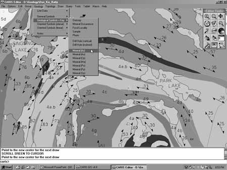 |
Figure 1. Example of a GEMM geological map displaying the GEMM 4 menu bar and Geology menu tree. |
Geological Menu items include Wizard panels for:
2) A Digitizer Geological Template Menu for easy and efficient digitization of geological line and point symbols. The digitizer Geological Template Menu allows the user to digitize geological symbols and line types from registered paper maps, field slips, aerial photographs, etc. onto the screen-map. Layer Tags are pre-set when digitizing from the template menu (fig. 2).
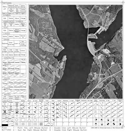 |
Figure 2. The Digitizer Geological Template menu. |
3) A GPS Field Data Collection Utility for locational accuracy and database entry. The CARIS GPS field data collection utility provides a direct link to the Global Positioning System (GPS) collection unit; allowing the user to download waypoints while simultaneously populating any Open Database Connectivity Compliant (ODBC)-attribute database. The waypoints are inserted into the map/database file using pre-selected geological symbology. The user interface is designed to automatically respond to the type of data to be collected. The utility displays a geotiff image of the map on which the data collected in the field are shown. The database interface within the map file consists of customizable forms according to the application of the user. They are accessible by clicking on the waypoint.
The GEMM courseware covers the following five steps commonly involved in completing a CARIS-based geological-mapping project:
1) Building a project basemap either by:
 |
Figure 3. Using CARIS SAMI, a scanned geological map can be converted into a digital map file retaining all its geology symbology. |
 |
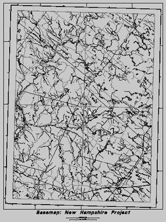 |
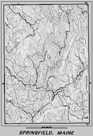
| Figure 4. Topographic basemaps created for Springfield, Maine (E00 Format) and part of New Hampshire (SDTS Format) imported into CARIS GEMM 4. | |
2) Adding the geology consisting of digitized line and point symbols using the GEMM Template in combination with registered field slips and/or aerial photographs.
3) Building network and polygon topology includes semi-automated map editing and supports the execution of a common range of GIS analytical procedures.
4) Building the legend so that the geological map can be distributed as a preliminary finished product in hard copy and/or digital format.
5) Adding polygon colors to the map file for improved viewing and map interpretation.
The way these five steps are approached may differ from project to project. They can be accommodated, however, at any level of complexity.
CARIS Manager with Zones. The CARIS Information Manager allows the management and querying of geographic and attribute data residing in a Geographic Information Database.
Digital Terrain Model (DTM) Viewer. The GEMM 4 provides DTM functionality for both triangulated irregular network (TIN) and regular gridded data sets. The DTM functionality includes a 3-dimensional (3-D) viewer, with adjustable viewing angle, sun elevation, adjustable projection, vertical exaggeration and other display settings. The user can also create contours and profiles, calculate volumes, and classify the DTM by elevation, slope or aspect. Tools are provided for draping map and vegetation features over a DTM, allowing the user to evaluate the effects of industrial development (such as open-pit mines) in the context of esthetic objectives and concerns.
Raster Imagery. The DTM function also provides for shaded black and white as well as color raster images from any X, Y, Z data using a gridded DTM executable. When generating shaded-relief raster images, the resolution, sun direction and elevation angles can be defined by the user to assist in geological lineament analysis. The GEMM 4 allows pixels within raster images to display both color, raw, and calculated data values, providing a basis for accurate data-recall and overlay analysis.
File Management and Multi-media. This program supports hot linking to various multi-media sources, allowing for the display of photos, drill logs, scanned sketch maps and other media, simply by clicking on a feature on the digital map.
Database Manager. Database connections with any ODBC database, allowing the importation of geo-spatial data directly onto the user’s digital map, are covered in the Database Manager. This program allows the user to perform table joins and multiple database queries, using the industry standard one-to-many protocol. It is being redesigned to more specifically respond to current geology database issues and objectives.
GEMM 4 EVALUATION
GEMM 4 provides for a range of geological data-entry, map creation, display and overlay analytical procedures that should satisfy most of the immediate needs of practicing field geologists (fig. 5).
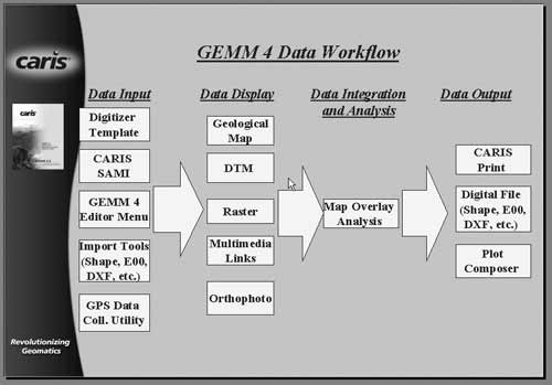 |
Figure 5. Flow diagram for the GEMM 4. |
Nevertheless, we recognize that improvements can be made to the geological database aspect of GEMM so that generating a database becomes an integral part of the mapping process. We also see a need to improve the way GEMM supports statistical functionalities and allows querying of attribute data. Furthermore, GEMM’s appearance is becoming old fashioned and legend building is more time-consuming than is desirable.
The evolution of GEMM is an ongoing process. Improvements to GEMM 4 will be addressed in our next generation of geological mapping software, Carta for Geology (provisional name).
BRIEF OVERVIEW OF CARTA FOR GEOLOGY
With respect to GEMM 4, Carta for Geology (fig. 6) is designed to better handle user-defined objects and other aspects related to modern geology independent of where and how they are stored. Attributes for these objects can be stored in a number of standard formats including Oracle, Access, CARIS GEMM files and shapefiles. Like GEMM 4, Carta for Geology will support geological symbology.
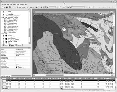 |
Figure 6. Screen-view of Carta for Geology (Overview Map not shown) In the top left corner is the Control window displaying the Layer list of each item on the map. Here one organizes and modifies a project, selects the features to be drawn etc. Below it is the Properties window where one can edit the color, relative size, and scale ranges etc. of map features. The Attribute data window, displaying the attributes of selected map features, is positioned across the bottom. The geological map, or a zoomed in version of it, is shown in the Graphics window. |
Some of Carta for Geology’s current main features are:
Major Carta for Geology features to be completed in the near future include:
Carta for Geology is being specifically designed to respond to what we think are the current and future demands of modern Geology.
With respect to the future of digital geological mapping, it seems clear to us that GIS has overwhelmingly failed to capture geologists’ interest to the extent that we no longer see emphasizing GIS as a viable way to market our geological mapping software. Accepting the premise that the main purpose of GIS is to support analysis, we suggest that the main purpose of geological mapping software should be efficiency in data acquisition, map display, map data analysis and the supply of data files in support of GIS in a range of common formats.
Except for the statistical display of structural data (fig. 7), geologists tend to be ambivalent about database issues; they see the database as detracting from the spatial aspects of geological mapping and filling out and maintaining database tables as not their responsibility.
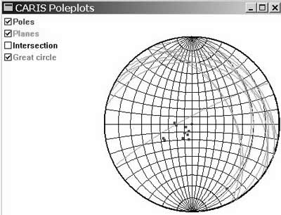 |
Figure 7. Stereonet plot of a selection of first generation inclined cleavage orientations extracted from the Carta for Geology attribute list. |
However, being able to automatically populate and edit the Attribute Data List (database) by editing geological point and line data in their spatial context on the map, the way Carta for Geology does, should overcome this ambivalence. This map-database connectivity is specifically intended to bridge the gap between historical working methods and objectives of the mapping geologists and their priorities concerning the geological map, and the current objectives of the geology data managers and their priorities concerning database analyses.
Additional features that most applied geologists would likely be looking for in geological mapping software include:
CONCLUSIONS
Geologists are entering the world of digital mapping slowly and with a great deal of trepidation. This is understandable considering the geologists’ widespread fear that GIS mapping objectives will force them to give up the geological map as the principal means for the display, interpretation, and dissemination of geological data in exchange for the geological database.
Current software widely used in geology makes it relatively easy to disseminate, query and analyze geological data in database format but does not meet the demands for easy map creation. The continued emphasis on this type of software in geological mapping can have long-term educational and professional implications that may seriously affect the quality and supply of digital geological maps.
Recognizing this potential problem, the intention of this paper is to draw attention to the need for geological mapping software that, while being capable of supporting GIS analysis, retains a strong geological focus as defined from the perspective of practicing geologists. The CARIS GEMM 4 and Carta for Geology are used here as examples of the type of software that may gain the confidence of the geological community. Carta for Geology in particular is designed to straddle the divide between proponents of the geological map and proponents of the geological database. In addition, it allows web-client access to both components for viewing and querying in a range of native formats using CARIS Spatial Fusion.